Peak Master Survex File - Call for help

Rob

Well-known member
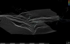
A Peak survex master file is starting to be put together, building on the proven-useful Castleton Caves Project. This will eventually span many catchments, especially those which may have a hydraulic, geologic or historic connection. Currently Castleton, Stoney and Bradwell have been included, and maybe soon it will grow into Wormhill and Wye catchments also.

The work in progress survex file can be downloaded from here:
https://www.dropbox.com/s/k5bglb8hu8089ks/Peak_Master.3d?dl=0
In the fullness of time we will put this in a more permanent and easily accessible location.

We would be very grateful for any assistance with populating more data. Please can everyone look through your own (or club's) survey data records and get in touch if you have anything missing from the file. For non survex users, this is basically all of Bradwell (bar Bagshawe) and much of Stoney. Paper surveys are better than nothing, but original survey notes or electronic data is really what we?re after.

In many situations the only solution will be getting caves resurveyed with modern techniques, and so we?re of course looking for helpers ? we?ve a long list to be getting through! We will keep the file that this links to updated as new stuff comes in, but maybe do check with us before you go off and resurvey something in case it has been done recently.
 

Cookie

New member
Hi Rob,

You are probably well aware of BCA's Cave Registry Data Archive but I'm going to plug it anyway.

The Archive is a safe repository for survey data so that it is not lost to future generations. Had it been available in the past your current project would be far, far easier with no need to survey any caves for a second time.

Please consider uploading the Peak data. It'll be in good company - checkout the existing data sets.

Currently the archive consists of some 20GB of data and is constantly growing.

Other than being a simple backup it also has tools to help coordinate the work of multi-person projects that you may find helpful.


Mark

Well-known member
Rob
I have scans of quite a few of John Becks survey books, will send copies if you haven't already got them.
 

pwhole

Well-known member
I'm wondering what the solution is for paper-only surveys. For example, I have a paper survey of Windy Mine on Moss Rake from 1938, which is very accurate. However, all surface detail has been removed now, so apart from an accurate GPS fix and altitude, there's not much to add to Survex. Can some of this be 'faked'? As in, can the paper details still be added as basic stations - shaft depth, horizontal extent of workings, etc.? Once an adjoining site that is accessible provides actual data, it would then allow the 'paper sites' to be tweaked a little if necessary. I know it's not 100%, but at least it fills in the gaps to some degree. There may be further surveys in the Chapel library, but I'm sure other copies would also exist elsewhere.

Windy Mine (not surprisingly) was on the top of the hill up from Bradda, beyond Outland Head, but before the road bend at Hartle Dale top/Sidebottom's quarry entrance.
 

MarkC

Member
Hi Rob, I digitalised all of John Becks paper surveys of Stoney Middleton Dale into GIS for the conservation audit. The data is availible as one 2D georeferenced shape file,  which hopefully you could convert or do something with?

I caused John a bit of a headache when I digitalised the data, as I found an error in his carlswark .dwg file (also availible) when overlayed on the hand drawn paper survey. It took him about a week to find the cause was a clinometer error in NW Passage, which he didn't thank me for!

Mark
 

Rob

Well-known member
Cookie, yes we're well aware of the BCA Registry. We may well use it as a backup in the future, once the project becomes more developed. However the multi-user-interface of DropBox is going to take some beating for active WiP projects.

Mark, I would definitely like to receive scans of JSBs survey books! We have lots of his work, but probably only a few percent of what he did! Cheers.

Pwhole, yes paper surveys can be "faked" back to original data if necessary. This can work as a very useful resource until "proper" data comes in, and we just add notes in the background to ensure we remember it's fake. Obviously it's very difficult to get good fake data if there is not both an elevation and plan view.

MarkC, the 2D data would be good to add to the project Archives, although it will only be of limited use as without the clino readings we cannot "upgrade" it into 3D.
 

Mark

Well-known member
Can someone split this topic please, as the original post is quite important
 

Rob

Well-known member
aardgoose said:
Oxlow appears to have gained a parallel entrance series (it stands out with the LRUD walls displayed)
Well spotted. As part of the project the whole Giants_Oxlow_Maskhill system is in the process of being resurveyed(!). Oxlow entrance has proven tricky so far with two separate trips both giving erroneous results. Basically it probably needs doing a third time, but until sorted both modern versions have been kept in....

Your attention to detail probably suggests your interested in helping?!?
 

A_Northerner

Active member
Hey Rob,

I'm not quite sure if you've already checked this with us - or exactly what you're looking for regarding any data we have. But the SUSS library is now re-installed in my house and you are free to peruse it at your leisure.

I can take a look at our data at some point if you can think of any previous SUSS projects that would add to the master file.
 

AR

Well-known member
It would be good if it's still in the SUSS library, I asked Steve Thompson last night about whether any of the original  team might have the surveydata from the Bradwell Moor campaign and he was doubtful. They certainly did New Venture and Bird Mines, not sure which other sites got done back then?
 

cavermark

New member
The first few SUSS journals had write ups of lots of Bradwell moor stuff including a Longrake and New Venture survey IIRC. A look through those might give a list of sites to look for original surveys/data for, within the SUSS library.
 

pwhole

Well-known member
I've emailed Rob scans of SUSS surveys of shafts along Long Rake, Brunt, New Venture, Bird etc. from 66-69 era. It seems that Brunt has been filled in now, but Marchington shaft to the west of it (or an adjacent opencut) may still be open, but it's well dodgy on that vein (New Rake), and would need a carefully planned descent with plenty of backup.


Attachments

  • _IGP9259_ex_sm.jpg
    _IGP9259_ex_sm.jpg
    82 KB · Views: 155
  • _IGP9260_ex_sm.jpg
    _IGP9260_ex_sm.jpg
    80.2 KB · Views: 160

Rob

Well-known member
A_Northerner said:
Hey Rob,

I'm not quite sure if you've already checked this with us - or exactly what you're looking for regarding any data we have. But the SUSS library is now re-installed in my house and you are free to peruse it at your leisure.

I can take a look at our data at some point if you can think of any previous SUSS projects that would add to the master file.
A_Northerner - Thanks for the offer/invitation. As suggested above, i have indeed been sent some information recently already regarding SUSS activities which has is great. Much of this includes surveys which i have started taking fake data off and populating the Master file. Also Phil has sent an excellent list of entrance grid references for the Bradwell area which i need to work through.

However, because i'm primarily compiling survey information into a 3D format, the most useful information to receive is actual survey data, in whatever format. So far i have not got any of SUSS's original data for any cave they have surveyed (unless you can see it on the Peak_Master already). Therefore if you have any data that would be extremely gratefully received. This could be in notebooks, photocopies, electronic files, whatever!

Otherwise, best is to get surveying (i'll happily lend my DistoX).


On another note, i've now gotten my head around EA's surface data and have started populating the Master files accordingly. The data for Stoney looks particularly good! Due to file sizes i don't include all the data, but can easily add bits on request if someone has an interest in any specific area.
 

Attachments

  • Stoney3D.JPG
    Stoney3D.JPG
    165.9 KB · Views: 199

2xw

Active member
Awesome news Rob. Sorry I didn't ger on that. Dod you use cave converter or what?
 

Rob

Well-known member
Na i just processed it in Excel. The EA stuff was pretty tricky, but now it's done I can paste in any 2m data from the supplied grid files and export a .svx file.
The BlueSky stuff was a bit easier, although a much bigger excel file (+60mb). That I can actually choose whatever sized square to export from wherever. So each cave entrances could have their own small square...
 
Top