Cheddar Gorge Closed Due to Flooding.

The Old Ruminator

Well-known member
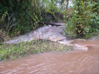
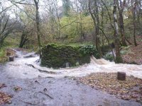
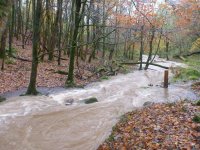
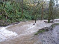
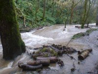
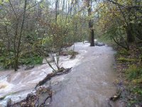
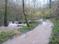
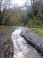
It seems like Longwood Valley Flood Sink has failed to cope with the deluge of rain yesterday and today with water pouring down the road again. We had 50mm in Taunton yesterday and similiar today. Maybe water coming out of Goughs again too. Our Tuesday digging cancelled tomorrow. Any updates welcome.
 

The Old Ruminator

Well-known member
" The B3135 through Cheddar Gorge has been closed on safety grounds. It was shut yesterday (Sunday 20 November) due to subsidence caused by heavy rain and flooding.

Water and rock are continuing to pour onto the road today, and the closure remains in place.

Somerset County Council?s highways team says it will reassess the situation later and sweep the debris from the route.  "
Last updated Mon 21 Nov 2016
 

The Old Ruminator

Well-known member
Vurley site hut sat in a stream and the shakehole is flooded. Water is cascading down the entrance pipe. A small ( nay stupid ) team will be investigating the damage tomorrow. :unsure:
 

rhychydwr1

Active member
I drove Cheddar Gorge on Sunday 20th in my 4WD go anywhere Subaru.  To my surprise there were no great hole in the road, just a torrent of water and a load of cobbles.
 

pab

New member
The photos posted show the huge torrent of water that is coming down Longwood Valley.
You can, just, see the rock at Longwood (Main) Sink.
Longwood Valley Sink is less easy to see!

074 - the stream flowing across the road (edge of road in foreground)
078 - the washing pool just upstream of Longwood Swallet
081 - Main Sink - with just the top of a boulder showing
102 - LVS
100- Also LVS - we appear to have a waterfall halfway along our spoil heap
098 - looking upstream towards the bottom end of the LVS spoil heap
095 - downstream of LVS
354 - the track below Black Rock quarry

All photos are taken by Ali Moody, except 354 which was taken by Pete Moody.
 

Attachments

  • P1080074.JPG
    P1080074.JPG
    118.3 KB · Views: 226
  • P1080078.JPG
    P1080078.JPG
    135.8 KB · Views: 227

pab

New member
pab said:
The photos posted show the huge torrent of water that is coming down Longwood Valley.
You can, just, see the rock at Longwood (Main) Sink.
Longwood Valley Sink is less easy to see!

074 - the stream flowing across the road (edge of road in foreground)
078 - the washing pool just upstream of Longwood Swallet
081 - Main Sink - with just the top of a boulder showing
102 - LVS
100- Also LVS - we appear to have a waterfall halfway along our spoil heap
098 - looking upstream towards the bottom end of the LVS spoil heap
095 - downstream of LVS
354 - the track below Black Rock quarry

All photos are taken by Ali Moody, except 354 which was taken by Pete Moody.
 

Attachments

  • P1080081.JPG
    P1080081.JPG
    127.4 KB · Views: 206
  • P1080102.JPG
    P1080102.JPG
    116.3 KB · Views: 202

pab

New member
pab said:
The photos posted show the huge torrent of water that is coming down Longwood Valley.
You can, just, see the rock at Longwood (Main) Sink.
Longwood Valley Sink is less easy to see!

074 - the stream flowing across the road (edge of road in foreground)
078 - the washing pool just upstream of Longwood Swallet
081 - Main Sink - with just the top of a boulder showing
102 - LVS
100- Also LVS - we appear to have a waterfall halfway along our spoil heap
098 - looking upstream towards the bottom end of the LVS spoil heap
095 - downstream of LVS
354 - the track below Black Rock quarry

All photos are taken by Ali Moody, except 354 which was taken by Pete Moody.
 

Attachments

  • P1080100.JPG
    P1080100.JPG
    102.9 KB · Views: 196
  • P1080098.JPG
    P1080098.JPG
    124 KB · Views: 190

pab

New member
pab said:
The photos posted show the huge torrent of water that is coming down Longwood Valley.
You can, just, see the rock at Longwood (Main) Sink.
Longwood Valley Sink is less easy to see!

074 - the stream flowing across the road (edge of road in foreground)
078 - the washing pool just upstream of Longwood Swallet
081 - Main Sink - with just the top of a boulder showing
102 - LVS
100- Also LVS - we appear to have a waterfall halfway along our spoil heap
098 - looking upstream towards the bottom end of the LVS spoil heap
095 - downstream of LVS
354 - the track below Black Rock quarry

All photos are taken by Ali Moody, except 354 which was taken by Pete Moody.
 

Attachments

  • P1080095.JPG
    P1080095.JPG
    129.6 KB · Views: 208
  • P1000354.JPG
    P1000354.JPG
    161.7 KB · Views: 222

The Old Ruminator

Well-known member
On Mendip today and Cheddar Gorge still closed. Went solo down Vurley and we have a whole new cave. From the entrance to the end has been scoured clean by yesterdays stream running down the pipes. Still inlet streams running to arrive at the bottom dig and sink in the choke. Wonderful.

Yesterday's lake has dropped by a metre.

upload images free

Stream entering clean washed final choke.

screen capture windows 7
 

Ali M

Active member
LVS reopened today by a combined caver / SWT team and now taking all the flood overflow from Main Sink. By the time we left  no water was flowing on to  Black Rock gate and Cheddar Gorge.
 

The Old Ruminator

Well-known member
July 68 was approx 6 inch's of rain in a very short time. MR O'Doc and I just escaped being drowned in Swildons. The recent event was about 4 inch's of rain spread over three days falling on saturated ground by the last day. July meant instant run off as the ground was fairly dry and the rainfall had no time to soak in. There was much more damage across Mendip in 68 including the road being swept away in Velvet Bottom and the road torn up in Cheddar Gorge. This time the main problem in the gorge was pebbles and small rocks strewn across the road rather than holes in the road.
 

pab

New member
Ali M said:
LVS reopened today by a combined caver / SWT team and now taking all the flood overflow from Main Sink. By the time we left  no water was flowing on to  Black Rock gate and Cheddar Gorge.

Staying on the theme of Cheddar Gorge .......

Photo is of one of the SWT team clearing LVS 

https://s22.postimg.org/4udc18na9/P1080166.jpg

And of the damage that the water has caused to the Gorge

https://s13.postimg.org/j35w18q8n/P1080159.jpg

Photos taken by Ali Moody

Photo of water /  debris at Black rock


This photo taken from Somerset County twitter feed

https://s16.postimg.org/gaadll3id/Image_1.jpg
 

pab

New member
My mistake .....

It came up on my Twitter feed and it's right next to a Descent piece.

Apologies
 
Top