Peak History

MikeyP

Member
Having posted an account on the discovery of Nettle recently, it got me thinking whether it might be an idea to have a thread where people can share any accounts/pictures/info of exploration in the Peak.

Accounts that may well have been published in club journals, but if people have them to hand on their computers and wouldn?t mind sharing?

As well as it being quite interesting, I wondered if it might be a nice resource to have everything in the same place and easily accessible.

What I have tends to be from the black and white era, but it would be interesting to have things from the 50?s onwards too!

Who knows, it might even uncover some long forgotten leads  (y)
 

MikeyP

Member
Oxlow:

The Rediscovery of Oxlow Caverns - W.M.Sissons

Very little was known of this place when the D. P. C. started to explore it, the men who went down in 1876 being all dead. In that year a horse, which belonged to a farmer living near the mine, disappeared whilst pasturing, and the owner had two miners up from Castleton to explore the shaft, which is very narrow in places. They found the horse dead at the bottom, and were told to re-timber the place throughout. The farmer?s idea was to get everything into a safe condition, and then open it as a show place, as the two miners brought out such beautiful specimens, and gave accounts of such magnificent natural caverns, that he thought it would be a profitable venture.  However, it was never opened for tourists, and after timbering the mine where necessary, it was lost sight of.

In November 1909, F. A. Winder, J.W. Puttrell, C. Baines, J. W. Percival, and W. M. Sissons went up to explore, previous to holding a Club ?meet? there. Taking only 70 feet of rope ladder and a rope or two, they did not get very far into the workings below.

In December 1909, the Club had a meet there, and some very fine sights were seen. The first shaft, which is only 60 feet deep, is very narrow, and wet at the bottom. This shaft leads to a 70-foot slope, which requires care in descending. Although not at a steep angle, it is slippery and loose in places.  Down this slope, ladders, ropes, pegs, beams, cameras, etc., etc., were taken. At the bottom a chamber was reached which is approximately circular, and has a sandy floor. In one corner a raised stone bench was found, and a riddle (very much decayed), which shows that lead ore had been crushed and dressed there, before being brought to the surface. There is a small sump in one corner, but this was not descended by the Club, as it had partially run in.

A sandy slope was descended, and a narrow passage about 3 feet high and 2 wide entered. This led to the top of a gulf 40 feet deep, with stemples all the way down. Water could be heard roaring. This place was descended on a rope ladder. At the bottom was found a beautiful cascade of limestone deposit. In wet weather (as on the occasion of the exploration) there is a torrent running down it. This wet slope was descended, and the side of a huge and beautiful chamber, 240 feet high and 40 feet wide, down into which the water pours, was reached.

A small crack gave access to a ledge about 4 feet wide and 6 feet long. In one corner of this ledge was a 30-foot sump about 2 feet wide. This was descended on a fixed rope, and brought the party about halfway down the great chamber. An easy slope about 80 feet ended in another drop. This was descended by the aid of stemples, which were found to be in perfect condition. Another slope led to the bottom of the large chamber.

The floor was all rock and flat. In one corner were a great number of cave pearls. From the roof on the left dropped a stream of water, which ran away down a crack on the right-hand side of the cavern.

Moving forward, a narrow passage was reached about 30 feet long, with a vein of lead in it 2 inches thick. This passage came to a blank, and on returning, a 28-foot sump was found, terminating in a small circular chamber. There was a hole about a foot wide and 3 feet deep in one corner, leading to a small chamber, but further progress downward was barred by blocks of stone fastened securely together by the limestone deposit. Magnesium showed the water dashing into spray, and all the walls glistening with moisture.

A return was made to the bottom of the sump with the waterfall coming down it. Passing under it, and continuing forward, another passage, fairly wide and high was found, leading to the top of another large cavern. On one of the walls was chiselled  ?J. J. /76,? the initials of one of the miners who timbered the place. The roof in places down the slope was rather treacherous.

A slide down a sump about 15 feet deep, in the shape of a corkscrew, brought the party on to a loose, sandy slope. The loose floor was soon passed over, and a good hard rock channel, which had stemples in all the way down, reached. In 30 or 40 feet this ended in a lip, which required a rope ladder.

About 30 feet above the top of the lip two chases were cut in the side of the rock near the floor, so as firmly to wedge a 5-inch by 4-inch timber across the rocky channel. A 100 feet rope ladder was slung over the lip. At the bottom of the cavern a small watercourse, down which a little stream trickled, was found. Two of the party pushed up this, through thick mud, which lined the sides. The first man noticed in the mud some prints of corduroy trousers, which looked as if they had been made a few minutes before. At least thirty-four years must have elapsed since anyone had been up, and yet the prints in the mud were quite fresh and clear. This watercourse was forced for nearly 100 yards, when it became too narrow, and so barred further progress.

On getting out of the watercourse another rather low passage was descended. This passage brought the party into a huge cavern, 220 feet long and 50 feet wide. The top of this place could not be seen, although six of the party held lighted magnesium, whilst two others were vainly trying to catch sight of the roof. Going forward, a floor was reached where the old miners used to crush and dress their ore, and so take it to the surface ready for the smelting furnace. Some old riddles all rusted through, which collapsed as soon as they were touched, were lying about. A big slope of large boulders, up the left side of which were some very rough steps, led to the entrance of a tunnel 20 feet long, cut out of the solid rock.

The far end of the tunnel terminated in another chamber with a waterfall coming from the roof. This was about 100 feet high, and the walls were covered with lovely formation. At what appeared to be the end of the place a sump was noticed in the floor. This was found to about 40 feet deep, with an avalanche of water dropping down. It was forced using rope ladders and at the bottom a small yet beautiful cavern found.

Down a passage the water rushed and disappeared into the darkness. The stream was followed for some distance, and it was found to tumble into a hole. The sides of this underground lake were examined, but no sign of any exit for the water could be seen. The party concluded they had reached a siphon, and also the lowest cavern.

The return proved a somewhat arduous undertaking.
 

MikeyP

Member
The author on the first descent in 1909. They were clearly very tough back then...
8351079307_1ed8984964_z.jpg


Pitlamp

Well-known member
This is great.

They had to be tough in those days; only 5 years later the toughnes of many of them was tested to the extreme in far less pleasant circumstances than caving endeavour.
 

jonnyrocketboots

New member
What a fantastic read Mikey, Thanks for that. Sorry I can't contribute but if you have anything similar then keep it coming!  Taking on board Pitlamps input as well I wonder if these lads ever went on and got involved with WW1 Tunneling projects as part of the Battle of Messines?!?  Cheers for stirring an interest MikeyP and Pitlamp. I'm off to look into it!  :coffee: (y)
 

MikeyP

Member
Peak/Speedwell:

Kyndwr Club Exploration of Speedwell Mine to the Bottomless Pit May 4th 1901 - Alderman Henry Arnold Bemrose

The entrance to the Speedwell Cave, generally called the Speedwell Mine, is at the bottom of the Winnats, Castleton. The Speedwell level was made in the 17th century in the hope of reaching some of the rake veins which run through the hill. At a distance of 750 feet the level reached the New Rakes which was a large swallow hole or a long narrow cavern. It was estimated that 40,000 tons of rubbish from the driving was thrown into this chasm without any visible effect. It was therefore called the Bottomless Pit and later the level was driven a further 600 feet. The level contains water and the voyage is made in a boat.

An exploration of the Bottomless Pit was made by the Kyndwr Club on May 4th, 1901. We were let down from the platform, which is built into the cave, by means of a boatswain?s chair and rope. The shape of the cave is something like a long and large oval barrel, the bottom tilted towards the east and at the top towards the west. Fourteen men went down to the pit through a small waterfall on to the wet sloping floor. A walk of 30 feet east with a fall of 10 feet brought us to the edge of a pool of water. The intervening slope down which we went was inclined at an angle of about 35? to the horizon.

A raft was improvised to find the depth of the water. Mr Puttrell was pushed out on the raft and took soundings with a plummet. The depth varied from 18 to 22 feet. The bottom of the pool was 85 feet below the platform and 689 feet above sea level. We were unable to find the height of the cave. We sent up a rocket with a string attached to it to a height of 108 feet but it hit against the side of the cave. The height of the ground above the cave is about 1,300 feet and if we deduct from this height the platform we conclude that even if the cave reached up to the surface of the ground the top could not be more than 187 yards above the platform.

The water from the level flows into the pit but whilst we were down below the gate was shut so that only a small quantity escaped. Dr Jamieson investigated the fauna of the cave, which included various insects and crustacean wanderers from the outside and three blind species, viz: Lipura ambolans, Tomocerus tridentiferus and Lipura inermis. The last named was not previously known in any English Cave but it occurs in the Mitchelstown Cave in Ireland.

8353828562_b534f08b30_z.jpg

The Kyndwr Club outside Speedwell 1901. They were to disband in 1906, and went on to form what is now the DPC. Puttrell is on the far right.

8353827652_542b5d168e_z.jpg

Puttrell about to be lowered from the bosun?s chair, at the Bottomless Pit. First tried out on Eldon Hole, earlier that year

8353828034_d18be9f48d_z.jpg

Puttrell exploring the Bottomless Pit. Clearly been touched up by a very early version of photoshop!
 

paul

Moderator
As you said, this is great stuff. However it may be better on the UK Caving Wiki as it is more "up front" there and easier to find.

The problem with Forum topics like this is that they soon get buried as time goes on and unless you search for them, you may not know they exist. Also they tend to get "diluted" with the inevitable off topic drivel whcih usually makes an appearance sooner or later.

I would suggest that for information which is always useful, the Wiki is better and for stuff which is transient, the Forum is better.
 

dunc

New member
Why not set up a Peak history page on the Wiki with some brief details and include a link to this and any other related threads?

Interesting stuff, by the way  (y)
 

MikeyP

Member
Fair point about wiki, I?ll add a bit more stuff here for the time being. Things could always be copied there at a later date. I kind of like the idea of having a place where info can be shared, discussed and added to in an evolving thread. Might not work, but worth a shot!
 

MikeyP

Member
Glebe:

The Reopening of the Glebe Mine. - H.G.Sissons.

(From the first ?published? journal of the DPC November 1935.)

The Town End or Glebe Mine is situated in. the village of Eyam, between the Church School and the Mompesson Tea Rooms. As the name indicates, the mineral rights are vested in the Ecclesiastical Commissioners, and at one time, the vicar of that day enjoyed an income of ?900 per annum from tithes and royalties. Thc last owners were the Eyam Mining Company who ceased operations in 1888,  the shareholders receiving a dividend of 7d per share. From that day till 1927, no descent had been made.

In 1927 three of us, Ken Seville, W.M.Sissons and myself, decided to investigate and, as a preliminary, the mine was ?nicked? under the old Derbyshire mining laws. A claim was registered with the Barmaster, the customary notice was posted at the mine head, and after the expiry of 21 days, the mine came into our hands, no previous claimant having come forward to ?keep off the nick.?

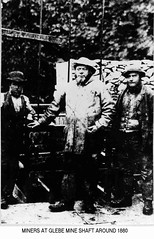
During this time we spent many interest-ing days searching the village for information. Needless to say, we soon heard how ?t?owd men? had just reached a fabulous vein of lead, when ?th?watter flooded ?em out?. This can be said of any mine, anywhere in Derbyshire. Special mention is due to Joe Twigg, subsequently the village post-man. All through our ownership of the mine, he was most useful, preparing the ground, organizing winding squads and looking after the place generally. Mrs Rowlands provided us with a changing and lamp room, and cheerfully fed us at all hours. Originally, in the early days, her cottage was the Mine Office, and now it was in use again - for, in her parlour, three happy maniacs hatched plots of prodigious development. Luckily, we came across Mr Maltby, whose father had been connected with the mine when last worked. He lent us an old plan which we transfered on to the large scale ordnance, adding further details gathered from long talks over many pints at the ?Miners Arms.?

By this time we were getting very keen, and anxious to explore the many workings promised by the old plans. Tackle was discussed and Ken looked out some shear legs, a hand winch and a kibble. W.M. & H.G.S., obtained 400 feet of plough steel wire rope. It was thought that signals and messages would be difficult to transmit from the lower levels, and so a portable and waterproof telephone was rigged up. The old plan indicated a climbing shaft about 350 yards north of the main engine shaft, but the only trace of this above ground was a grass grown hollow, which was obviously a ?run in.? Therefore we decided to concentrate on the main shaft and work our way forward from there. The Great Day arrived and many helpers from the village shifted the stones of the large beehive over the top. Underneath was a layer of rotten planks. These on being removed disclosed an excellent shaft about 8 by 6 feet, well built as far as we could see. W.E.Amies now joined us and took charge of the ground work, while Ken, W. & H.G. prepared for the descent. A powerful petrol gas lamp was lowered on a measured line and the walls carefully inspected with binoculars as the patch of light went down. Finally, bottom was reached at 320ft. As we listened, a faint roaring was heard, and the glasses disclosed a swift flow of frothing water moving south east. This was good news, as here our plans showed the Moorwood Sough running in that direction. We made preparations for a drenching while the lamp was drawn up. The shear legs and the winch being fixed, stones were placed in the kibble. Several trials showed that the legs were unsatisfactory, so we scrapped these and moved the winch directly over the shaft, supported on strong planks. This worked much better. Ken and H.G.S. packed into the kibble, earphones were adjusted, phones tested, lamps lit, and the bar was drawn.

Then, looking rather ridiculous and feel-ing rather lonely, suspended in our little barrel, we sank slowly from the gaze of the vulgar. Too slowly, for we heard a rheumy old native explain-ing to Billy Amies, how he remembered three of his mates being killed ?down th? shaft.? Billy wound us up again to make sure we had heard!

Thirty feet finished the built portion, chang-ing to solid limestone in first class condition. Fifty feet showed levels east and west, where we ?phoned for a halt and fended to the side with our broomsticks. The levels running into the vein were rather small, so we decided to investigate later, and signaled further descent. There was little of interest, only that we commenced to spin violently until we steadied ourselves by the sticks. All down the south side were stemple holes, but except in one or two places the stemples had long since disappeared. At 150 feet, water began to trickle from the sides and steadily increased till we were under a pouring shower. Meanwhile, the faint roaring we had heard at the top grew louder and louder. We now had to shout to each other to make ourselves heard. ?Phoning was difficult and we wondered whether hearing no signals from the bottom level, the winders would lower us into the water! 240 feet disclosed a large bell shaped chamber, and here we paused again to seek a landing place. Eventually, we thought it advisable to reach bottom first and return for exploration on the up journey.

The noise was now terrific, and water had entered the ?phone, but we managed to explain the situation to the top - that the ?phone might become too bad for speech and that we would signal movements by the buzzer. Off we went, and at 320 feet reached bottom, luckily coming to rest on a lime coated heap of debris, the water flowing each side. After great trouble we lifted our legs from the kibble.

We were now in the Moorwood Sough which drains several of the Eyam mines, runs under the village Square, under Cliff Stile Mine and emerges near the stables in the grounds of Stoney Middleton Hall. Owing to the accumulation of falls and old stemples, the south east exit was submerged under the water, and its only indication was an unpleasant swirling pool, which gave out a periodic sucking noise as air was drawn in with the current of water. The noise we had heard whilst descending the shaft appeared very much less here than it had further up. Probably this was due to the less confined space.

Turning north east, we moved up stream, the roof varying considerably due to old stoping work. There were signs of another shaft, but this had filled in. 150 feet brought us to a full stop, a large fall closing the level, except for the passage of water. A prolonged drought might possibly reveal the main passage leading to the workings under Eyam Edge.

Returning to the shaft, we looked up and signaled our return. There was a long pause and we crouched miserably in the barrel while the water soused upon us. Eventually we were off, and reached the bell shaped level at 240 feet. Here we swung ourselves to and fro, seeking the best landing place. The shaft widens and it is very difficult to catch hold of the edge. Later on, we were to become very skilled at this manoeuvre! One shove; a swing; a cannon off the left hump and we were safely hooked on dry land! Just now it was not easy. After several futile attempts, Ken in desperation, gripped a ledge and I held his boots as the kibble swung back - not unlike the comic pictures of the unskilled punter. Unloading the tackle, we fixed up the ?phones and signaled for the next man. The kibble disappeared, and we sat down for a breather and to wring out our wet clothes. Twenty minutes later a fusilade of language signaled the approached of W.M.Sissons. He brought news of the excitement above.

It looked as though the whole village had turned out to see the old mine reopened. They were gathered round the mine head. Gnarled ancients addressed the winders with gruesome anecdotes. Small pop eyed boys gazed at Billy, ?phoning us below. Every movement he made was watched tensely. He was God-like! Later on even, a village dance at the Institute was denuded of it?s younger men, so that altogether our investigations were not a secret. Joe Wells had turned up and was with Billy.

Safely landing W.M.S. we moved west. On the left was a small level in the floor vein, about 40 feet long. Returning, we found the main passage ran parallel for 60 to 80 feet, with stoping work above. Slightly further back brought us to a four way junction. Ahead of this junction was a long passage with small cross cuts ending in vein stuff. To the left, a further passage ended in a crystal clear pool of water. About 30 feet to the right, brought us up against a clay bank, but before reaching this we came across a shaft in the floor. There was great excitement. It was a possible access to the lower levels. This was important in that it might be an alternative route to the extensive workings towards Eyam Edge and Dusty Pits Mine, which appeared closed to us by the falls at the 320 feet level.

A stone thrown down 50 feet, splashed into water and a weird sound followed, like a series of chuckles;  ?Ha, Ha, Ha, Ha,?.!!, continuing for over a minute. We thought of the three old miners killed many years ago. Another stone, and the same result. This time we realised that the ripples were trapping air in some chamber at water level. We were very loth to leave this unexplored, but we had no ladder, we had been wet through for hours and it was getting on for 11 o?clock. We would call it a day, and leave this and the levels running east from the main shaft until tomorrow.

Back to the shaft, the first man was drawn up with the tackle and specimens, while we tidied up generally. The kibble returned and up we went.

Fifteen minutes steady winding for those at the top. Cave togs off, supper, plans for tomorrow and deep sleep at Mrs. Rowland?s cottage were a prelude to the next and many other days of very interesting work.

8355928614_63e563b2d4_z.jpg


Jopo

Active member
MikeyP said:
Fair point about wiki, I’ll add a bit more stuff here for the time being. Things could always be copied there at a later date. I kind of like the idea of having a place where info can be shared, discussed and added to in an evolving thread. Might not work, but worth a shot!

I for one would like to see more. The photographs really enhance the records.

Jopo
 

Pitlamp

Well-known member
I'd like to see this stuff here, then discussion can take place. If items are then added to a Wiki at a later date, with the benefit of discussions having taken place, the Wiki entries will then be more authoritative and balanced.

Keep 'em coming MikeyP.
 

John B

New member
That is a great account of Glebe from the Sisson brothers. I hadn't seen that one, or the photo. I didn't think they made their descent until the 1930s, but they must have known the place pretty well by the time it was reopened for fluorspar in the mid-1930s.

This one may be of interest. It is supposed to have been taken around 1880.
8359443472_959654b491_m.jpg
 

Big Jim

Member
John B said:
That is a great account of Glebe from the Sisson brothers. I hadn't seen that one, or the photo. I didn't think they made their descent until the 1930s, but they must have known the place pretty well by the time it was reopened for fluorspar in the mid-1930s.

This one may be of interest. It is supposed to have been taken around 1880.
8359443472_959654b491_m.jpg

Is that you on the right John? :LOL:
 

Rob

Well-known member
Awesome post MikeyP, thanks for uploading. I'm looking forward to hearing about their next trip down there  (y)

MikeyP said:
So would this possibly tie-in with the new Doom system?  :-\
Kind of, it's all part of the same system, just quite a long way away.
 

Nigelh

New member
Great stuff all round!  :clap:

I thoroughly enjoyed the Nettle Pot history thread, especially so after the photos were added. This latest thread is a cracking idea. Well done Mikey P for starting it and to all those who are contributing. This is giving me something worthwhile to read at lunchtime.

Oilskins and woollens ! Gadzooks!
 
Top