Peak District Conjecture.

bograt

Active member
Having spent time recently researching Pin Dale Quarry, my fermented mind started drifting;

It is widely accepted that Pin Dale Quarry intersected an abandoned cave passage, the original flow being out of Pindale Quarry Cave (PQC) and into Black Rabbit (BRC) IIRC.
It is also thought that PQC is likely to connect to somewhere in the E side of Peak Cavern after it has negotiated Dirtlow Rake.
After spending some time in BRC in the late '70's early '80's we came across a small stream which appeared to trend to the SE., heading towards Outlands Head, a now lost system strongly suspected to link with Bagshawe.
Question; Is Pindale a possible key to a hydrological link between Peak and Bagshawe?.
I realise that accessible passage in this area is unlikely due to mining and quarrying activities but nevertheless it is an intriguing idea and could be resolved to some degree by a study of surface related surveys of the whole area including East Peak Cavern, Bagshawe, Outlands Head, PQC, BRC, maybe Moorfurlong, Bird and any other mines known to have natural development in the vicinity. Do any such SR surveys exist?

Straying further into the realms of fantasy, I came across a suggestion recently that Milldam Mine straddles the watershed between Bagshawe and Eyam Dale, a link between Peak and Carleswark would be a target to aim for !! :eek:
 

nickwilliams

Well-known member
bograt said:
I came across a suggestion recently that Milldam Mine straddles the watershed between Bagshawe and Eyam Dale

Bearing in mind the locations of Milldam's entrance and Ladywash Shaft, I'm struggling to understand how that is any sort of a surprise?

Nick.
 

bograt

Active member
Rob said:
The "Stoney Castlewell" system you mean.  (y)

More such conjecture here: http://ukcaving.com/board/index.php?topic=8595.0

Aah, but they overlooked the Pindale factor in that thread :)
nickwilliams said:
bograt said:
I came across a suggestion recently that Milldam Mine straddles the watershed between Bagshawe and Eyam Dale

Bearing in mind the locations of Milldam's entrance and Ladywash Shaft, I'm struggling to understand how that is any sort of a surprise?

Nick.

'Never said it was a surprise :unsure:
 

Rob

Well-known member
Staying on the discussion regarding Pindale, the Castleton Caves survex file shows the altitude of BRC and PDC as 272m, which makes it 78m above Peak resurgence. Although almost certainly not directly relevant, this is about the same altitude as the Victoria Line passages near the top of Victoria Aven.

I cannot think of any known passages that are obviously associated with this. The closest (but still very far-fetched) suggestions i'd have would be whatever is at the top of The Ramp, whatever is past Doom's Retreat, or whatever is associated with Slack Hole....!
 

Pitlamp

Well-known member
. . . or Styx Inlet Sump . . . . .

The altitude difference isn't necessarily an unsurmountable issue; remember the Peak Cavern gorge is a former deep Vauclusian rising and phreatic passages associated with it can have great vertical amplitude as a result.
 

Goydenman

Well-known member
Is there not a case of again having a look at how to get into Pindale mine? It must have intersected cave passage. When they finally managed to open the sough I briefly popped by. From the small shaft I remember standing height passage that dog-legged right and then back left to run in with water coming through it. The dig was easy except for bad air. Having said that behind the blockage is likely a lot of water  :eek: They also tried to dig down to the sough further up the field but were unsuccessful.
 

graham

New member
Pitlamp said:
... remember the Peak Cavern gorge is a former deep Vauclusian rising ...

Is it? I imagine this is down to TDF's work, but I don't remember that bit. What was the barrier that it had to rise over? When was it breached?
 

T pot 2

Active member
Correct me if I'm wrong but isn't there a connection (dye tested) from Peak Caverns buxton water sump to Hollandtwine Mines swallow at an approximate depth of 415' feet from the shaft collar. I like Bograt have also conjectured that if you follow Dirtlow Rake east to Bennet Part and beyond a junction with Pindale Rake should exist. If so Black Rabbit could be part of the link towards Bagshawes.

On the Mill Dam mine suggestion, The reef limestone at grindlow controls the flow of water both west and east after lead mining took place, looking north from Douse holes water to the west now goes to Bradwell, looking east water flows towards Eyam and Stoney Middleton. Water from Mill Dam mine flows through mined passage that connects to Ladywash Mine, Glebe Mine and the tail of Moorwood Sough at Stoney Middleton,  so is the infered link between Bradwell and Stoney there by way of some natural and mined passage possible.

Put both of the above together and who knows could we have a megger system some day ?

Question

How deep is Titan from the shake hole top to Slop Moll / Russet Well rising.

Suggestion

If anyones interested would it be an idea to have a meet where maps surveys etc could be debated on the above ? this could be at a weekend or of an evening.


T pot
 

Pitlamp

Well-known member
graham said:
Pitlamp said:
... remember the Peak Cavern gorge is a former deep Vauclusian rising ...

Is it? I imagine this is down to TDF's work, but I don't remember that bit. What was the barrier that it had to rise over? When was it breached?

Yes I think so (re Trevor) but am short of time as I type to look for a ref for you / an ancient Hope Valley Floor / don't know as I'm currently not up to speed with stal dating in Peak.

If you go into Peak's Vestibule there is an aven on the right partway along. Climbing this leads to a steeply rising extension known as The Mendip Beer Monster's Secret Tap Room. It's a phreatic riser with a vertical range of (at least) 60 m; it "ends" where it is blocked by massive flowstone but is still steeply rising at this point. This is likely to have fed a (now buried) former Vauclusian rising on the hillside just west of Peak's entrance and gorge.

Answer your own question about what barrier this water had to rise over and you'll maybe also have answered the same question re Peak's main entrance?
 

Pitlamp

Well-known member
T pot 2 said:
Suggestion

If anyones interested would it be an idea to have a meet where maps surveys etc could be debated on the above ? this could be at a weekend or of an evening.

That's a very good suggestion T Pot. This is exactly the sort of function which the former DCA Congress used to be for (getting Peak District exploratory cavers together to discuss matters of mutual interest). They used to be very good and I was never really sure why they stopped happening.

We have of course had such get togethers in the past - remember that one day meeting on the Peak Cavern system in the 1990s? It got written up for BCRA and filled a whole issue of Cave Science, which is still extremely useful even today. That one (and others like it) have been organised independently by groups of interested cavers but as we are lucky to have a very good regional council (i.e. DCA) perhaps organising something formally, under DCA's umbrella, might be of value?
 

pwhole

Well-known member
Have any dye tests ever been done from the west end of Moss Rake? Rake Head, Hugh Hill Grove, Raddlepits area? I'm assuming that the former drainage (before mining) still mostly went down Moss Rake, in hitherto undiscovered phreatic passage and thence into Bagshaw. But is it possible that some Bradwell Moor water could drain over the lava, past Long Rake and Bird Mine, under the cement quarry and thence into Pindale?

I've seen some evidence which shows that there was once a lot of water pouring through these systems, not much of which is there now, but it doesn't seem to have been lowered by soughs or miner's swallows - as in, it was dry a long time ago.

And I'd definitely be up for a meeting.
 

Pitlamp

Well-known member
I have a vague memory that one of John Gunn's dye tests from the vicinity of Dirtlow Rake turned up both in the Peak system and also at Bagshawe Resurgence. If so, the two systems are hydrologically linked at least. (This is only based on memory though - and may have more to do with problems with detection rather than genuine flow - so don't take this comment as gospel.)
 

martinm

New member
Pitlamp said:
T pot 2 said:
Suggestion

If anyones interested would it be an idea to have a meet where maps surveys etc could be debated on the above ? this could be at a weekend or of an evening.

That's a very good suggestion T Pot. This is exactly the sort of function which the former DCA Congress used to be for (getting Peak District exploratory cavers together to discuss matters of mutual interest). They used to be very good and I was never really sure why they stopped happening.

We have of course had such get togethers in the past - remember that one day meeting on the Peak Cavern system in the 1990s? It got written up for BCRA and filled a whole issue of Cave Science, which is still extremely useful even today. That one (and others like it) have been organised independently by groups of interested cavers but as we are lucky to have a very good regional council (i.e. DCA) perhaps organising something formally, under DCA's umbrella, might be of value?

Good suggestion John. I will ask TPTB about it! Regards, Mel.
 

Moose

New member
Well we've spent close on 25 years trying (quite hard) to get beyond the boundary on the peak survey and so far failed miserably.

If anyone physically traverses a catchment area by means of natural cave systems in my life time then I will eat my head.

The answer to the Titan question is approx 238m to Russet Well surface.

Also the black rabbit input in the Survex model is not at all reliable, it would be a good idea to have a session fixing all the caves in Pindale quarry and getting some solid field data for all the caves therein.
 

bograt

Active member
On the subject of vaclusions, when I did my slide collection, it was noticed (spotted by Pitlamp, no less!) that the scallops in Lake Passage reversed flow direction, the phreatic part of the passage indicated an inwards direction, the vadose an outwards one, thus suggesting that the original section was developed before the cutting of the main stream canyon.
This might suggest that the big climb above Ink Sump could be vaclusion in origin, and the characteristics of the climb go some way to back this up. At the top of the climb is a broken area where many digs have been attempted, this is likely to be associated with Dooms Retreat beyond Ink Sump, a divers dig thought to have connections with Dirtlow Rake.
Anyone know anyone who might like to do a sediment particle comparison between the stuff from the Ink Sump climb and the stuff coming out of PQC?
Another area of interest on this subject would be Picnic Dig, another high level sediment filled phreatic tube trending generally in the right direction.
 

Rob

Well-known member
bograt said:
...This might suggest that the big climb above Ink Sump could be vaclusion in origin, and the characteristics of the climb go some way to back this up....
This is "The Ramp" I refered to in my original reply:
Rob said:
...The closest (but still very far-fetched) suggestions i'd have would be whatever is at the top of The Ramp...

This is because I am also a potential believer that Lake Pasage used to flow the other direction. For starters it currently flows NW, and all Peak/Speedwell's development is W to E, so it doesn't sit right. Then go look at the roof tube of the Mainstream Passage just upstream of the muddy slide up into Lake Passage, you'll see it continues straight into Lake Pasage, rather than turn left with the rest of the Mainstream Passage. Possibly it simply then turned left and back to the current Mainstream Passage along to where the water currently flows, but quite possibly carried on to the SE. That leaves two unknown options:
[list type=decimal]
[*]Up the Ramp
[*]To Doom's Retreat
[/list]
There's definitely something happening to the south of this system that we don't yet know about.....
 

Rob

Well-known member
T pot 2 said:
Suggestion
If anyones interested would it be an idea to have a meet where maps surveys etc could be debated on the above ? this could be at a weekend or of an evening.
I'm always up for an excuse for a meeting/piss up, but as for useful research this forum is proving to be a perfectly suitable medium for me... Gives you time to reflect and ponder, before asking about the next hairbrained ideas...!
 

pwhole

Well-known member
Other scraps that may be useful.

I haven't seen it myself, but there's a small rising in wet weather near Red Seats Vein that runs E-W across the bottom of Michill Bank, connecting Pindale and Peak Cavern Gorge - Red Seats is the vein that ends as the conspicuous opencut on the east wall, opposite Peakshole Sough, and was presumably also the leader they followed when the sough was first dug. This vein was mined from Pindale End and probably independently too. But the rising presumably comes from the hill, rather than the mine workings. If so, that's a source of water as-yet-untraced, and possibly from caves east of the current Peak system, but west of Pindale. There's info in that Chris Heathcote article on Pindale here:

http://www.pdmhs.com/PDFs/ScannedBulletinArticles/Bulletin%2014-6%20-%20Surface%20Remains%20of%20the%20Pindale%20Area,%20Castle.pdf

Also - Weather Rake is a very old vein that traverses the top of Michill Bank in a SW direction - it crosses Cavedale as a narrow opencut on the east side about halfway up the dale. Chris speculates in another article on Castleton Mines (not available online) that this vein may be the vein that Victoria Aven is developed on, and is also possibly the far eastern end of New Rake.

He quotes from Porteus, C. 1950, Caves and Caverns of Peakland, The 'Come to Derbyshire' Association, Derby:
The upper limit of the Victoria Hall is still not known...in one corner staves or stemples...used to be a ladder...climbed to about one hundred feet. There is a disused mineshaft two hundred or more feet above, and that may have been the original entrance to the cave.
I've been on the hillside above Victoria Aven , and there is a very large hollow, roughly in the right spot. If toadstone has been found in the chokes at the very top, that's presumably because the basalt outcrop is right beneath this hollow - in fact you climb over basalt blocks to get to this hollow.

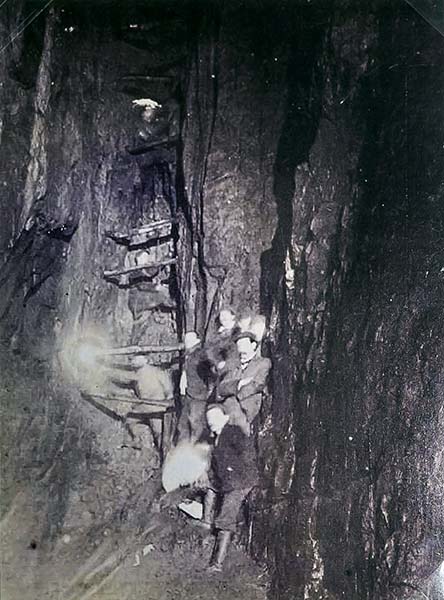
Here's a photo of Puttrell and pals at the base of Victoria Aven with the stemples still in place:

JWP_VA_sm.jpg
 
Top