Lidar Data

Mark

Well-known member
This might have been posted before quite a nice zoomable tool on NLS Maps

https://maps.nls.uk/geo/explore/side-by-side/#zoom=12.409999999999993&lat=54.06124&lon=-2.23628&layers=171&right=LIDAR_DSM_2m
 

Pitlamp

Well-known member
Thanks Mark; I've not seen that before. Just spent some time zooming in and out around my local area in the Dales. The major faults stand out well (Craven Fault system etc) and the north Ribblesdale drumlin field is spectacular. Hopefully the blank areas may get filled in as time progresses.
 

pwhole

Well-known member
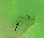
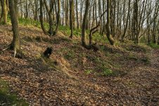
I've found tons of stuff in my local area using this tool - many unknown pits and rustic-industrial features, and now the only authenticated coal strike workings remaining untouched in Sheffield - their centenary year. This is the Whinmoor, or Mickley Thin seam, worked illegally by unemployed miners and their families in 1921. Sadly much of my area of interest in the Peak District isn't on the map! The 2m DTM has slightly better coverage, but not much.
 

Attachments

  • Whinmoor.jpg
    Whinmoor.jpg
    64.7 KB · Views: 133
  • _IGP2585_sm.jpg
    _IGP2585_sm.jpg
    390.7 KB · Views: 130

Lampwick

Member
pwhole said:
...Sadly much of my area of interest in the Peak District isn't on the map!
A detailed search of the DEFRA website shows where the gaps are, I think the Castleton catchment will have to wait until the end of the year. 1m DTM coverage map below:


Attachments

  • UKC Lidar 1m Coverage.png
    UKC Lidar 1m Coverage.png
    85.5 KB · Views: 130
Top