RobinGriffiths
Well-known member
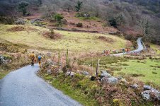
I had a little surface wonder around Rhyd, near Porthmadog yesterday, renewing acquaintance with some mines of old, as well as visiting a couple of new, obscure ones.
Ty'n y Ddol SH 6374 4259
This was a low collapsed adit at the base of a low cliff near a small river. Peeping inside showed it to be suprisingly long. I expected it to shut down after a few meters, but it appears to go at least 50m (it appears to curve to right so it may continue). Estimated 3' of water in the adit with 2' of airspace. There's no sign of spoil or mineralisation. It's in the Cwm Eigiau formation, so I wondered if it was a slate trial, however Coflein has it down as being a metal mine, and in fact, Wilkinson (Mines and Quarries of North Wales) has it down as being lead. No other details on the Coflein website.


Bryntirion SH 6366 4224
Two adits where the ground rises to the south of the Afon Rhyd. The upper adit was blind after 3'. The lower adit is blocked by a large slab, however a gap above the slab shows a flooded adit, although it's difficult to judge extent. Again, virtually no spoil, but the were some traces of iron staining. Copper according to Wilkinson.


Thence a walk via Hafod Boeth and Catherine and Jane to look at the Bwlch y Plwm opencast. There are accesible underground workings under the opencast, but it's 20 years since I explored these. These workings are (as far as I'm aware) not connected to the 'normal' Bwlch-y-plwm mine as used by outdoor groups.
My return trip took me down towards the farm, a route I've not done before, so there were a couple of interesting things I found. There's a blocked adit emitting water at the base of the large spoil heap in front of the opencast. I've got a feeling I may have got down to this level 20 years ago.
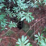
Further down, just behind the farmhouse is another blocked adit emitting enough water to form a pool. Presumably this must be linked to the opencast workings?


Finally there was a large bore square sectioned flooded 'shaft' a bit lower down the footpath, depth undertain.

Ty'n y Ddol SH 6374 4259
This was a low collapsed adit at the base of a low cliff near a small river. Peeping inside showed it to be suprisingly long. I expected it to shut down after a few meters, but it appears to go at least 50m (it appears to curve to right so it may continue). Estimated 3' of water in the adit with 2' of airspace. There's no sign of spoil or mineralisation. It's in the Cwm Eigiau formation, so I wondered if it was a slate trial, however Coflein has it down as being a metal mine, and in fact, Wilkinson (Mines and Quarries of North Wales) has it down as being lead. No other details on the Coflein website.
Bryntirion SH 6366 4224
Two adits where the ground rises to the south of the Afon Rhyd. The upper adit was blind after 3'. The lower adit is blocked by a large slab, however a gap above the slab shows a flooded adit, although it's difficult to judge extent. Again, virtually no spoil, but the were some traces of iron staining. Copper according to Wilkinson.
Thence a walk via Hafod Boeth and Catherine and Jane to look at the Bwlch y Plwm opencast. There are accesible underground workings under the opencast, but it's 20 years since I explored these. These workings are (as far as I'm aware) not connected to the 'normal' Bwlch-y-plwm mine as used by outdoor groups.
My return trip took me down towards the farm, a route I've not done before, so there were a couple of interesting things I found. There's a blocked adit emitting water at the base of the large spoil heap in front of the opencast. I've got a feeling I may have got down to this level 20 years ago.
Further down, just behind the farmhouse is another blocked adit emitting enough water to form a pool. Presumably this must be linked to the opencast workings?
Finally there was a large bore square sectioned flooded 'shaft' a bit lower down the footpath, depth undertain.
")