

You are using an out of date browser. It may not display this or other websites correctly.
You should upgrade or use an alternative browser.
You should upgrade or use an alternative browser.
Caves near Kendal (split topic)
- Thread starter Loki
- Start date
pwhole
Well-known member
A good friend of mine lives near Underbarrow and pretty much has limestone poking out of his garden turf, but I've walked around that edge to the east with him several times and not seen a great deal. Admittedly it was some time ago and I've got a lot better at spotting signs, but I'm not sure if there is that much to find - up there at least.
danthecavingman
Member
That would be the Natland Pipe cave, lost about 30 years ago when UU filled in the entrance as they laid a water pipe over the top of it. http://www.lakeland-enterprise.co.uk/Natland/Caves.html
TheBitterEnd
Well-known member
Helm gate mentioned in the article linked above probably has more potential and is not far from pipeline cave.
There are a lot of small resurgences around most of the limestone hills near Kendal, the tarmac sometimes gets popped off roads around Arnside after very heavy rain and if you walk around the base of Whitbarrow after heavy rain you will find loads. There are also small sinks particularly on Whitbarrow and Hampsfell.
I think the main issue for finding caves, apart from the obvious lack of a cap rock concentrating the flow is the thin beds which probably collapse fairly readily filling any reasonably sized void.
Does anyone know who was digging in Arnside cave?
Mrs Trellis
Well-known member
The Mint Cake mines should be extensive - there's a lot of it about.
Coat!
Coat!
Pitlamp
Well-known member
Fulk said:There's a resurgence at Holme, presumably fed by water sinking on Farleton Knott, that emits a large stream in wet weather; unfortunately it's located in somebody's garden.
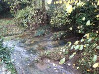
Is the resurgence in question the one which comes out of a culvert next to the road, which can turn the normally dry stream bed in Holme into a raging torrent (see picture, taken in only moderate flow)? If so, we've investigated this a while back. We found a very helpful couple who live in Holme who introduced us to various other key householders (as the situation is not as simple as it first appears).
The house owner where the "main" resurgence is was kind enough to listen and consider our request for access but she decided she does not want cavers involved. However, further back (near the cricket ground) there is another short section of normally dry streambed. Downstream leads into a culvert which is probably the source of the water rising from the "main" resurgence culvert. At the upstream end is another dry culvert leading beneath a bungalow. The owner of the bungalow was really good with us and allowed a visit. We took the opportunity to make a sketch survey of this, which we named "Culvert No.1".
This is 9 m long and ends at a downwards choke, through which pebbles could be dropped into deep water, in an echoing area which looked natural; almost certainly a static sump pool chamber from which a large volume of water rises in flood. However the roof is supported by a slab, which is resting precariously on a smaller rock, which is resting on loose material. All this is very close to surface and is under the bungalow owner's property. Our assessment was that any interference would be likely to lead to collapse of the ground above, unfortunately.
I post all the above detail to save others the effort of going for a look and / or unnecessarily pestering the bungalow owner. If anyone is especially interested, contact me off board and I can let you have the sketch survey and a couple of photographs.
However . . . . there is a good possibility that the impressive amounts of water emerging at Holme in flood are actually coming from escape of water from the canal just behind the village, rather than from the great bulk of limestone forming Farleton Knott. Which would then beg the question as to where the true resurgence is? Quite a lot of ground water appears a bit further away at Holme Mills, for example (but perhaps not enough to account for Farleton Knott).
Really, this is a work in progress. We do have other irons in the fire but we aren't rushing and it depends to some extent on waiting for contacts to be made. We don't want to upset anybody and it's outside our main caving area, so locals aren't used to cavers' requests.
But - Fulk - maybe you were referring to a completely different resurgence altogether? In which case, please educate me! If it's in a garden, we may know an influential local who could help arrange a visit.
Attachments
TheBitterEnd
Well-known member
Since we are talking resurgences there is a large resurgence ESE of Arnside Tower Farm, I keep meaning to sneak over the fence for a look. I know the farmer at Tower farm but the resurgence is not on his land https://maps.nls.uk/geo/explore/side-by-side/#zoom=16&lat=54.18644&lon=-2.82354&layers=10&right=BingHyb
There is a solution like feature in the nearby Middlebarrow quarry half way up the wall. Having all the climbing skill of a small elephant myself I did persuade a climber to go up for a look but he reported that it just closed down. Middlebarrow pretty much sections the whole hill and there is only the one feature so it seems that there are few caves in the area.
There is a solution like feature in the nearby Middlebarrow quarry half way up the wall. Having all the climbing skill of a small elephant myself I did persuade a climber to go up for a look but he reported that it just closed down. Middlebarrow pretty much sections the whole hill and there is only the one feature so it seems that there are few caves in the area.
Mr Dinwiddy
Member
Before Holme Park Fell (Farleton) was owned by the National Trust it belonged to a farmer (called Mr Bell IIRC) he told me about a cave there that his father covered over. It was on the bridleway that goes past the farm onto the fell. Just beyond the fell gate where the path steepens into a bit of a zig zag there is a spring and a small square concrete trough (or there used to be - not been there recently). This is on the right of the track- between the track and the land which is part of the quarry. The cave was there and was an open passage which the farmer and his brother explored as kids. The father was worried about safety and covered the entrance over/filled it in. I always meant to have a look there in flood resurgence conditions but never got round to it. So if the story is true there is open cave passage somewhere there. The proximity of a spring which is quite constant adds weight to the tale.
mrodoc
Well-known member
Just after we started caving we visited a short tube system that I recall as being on a river bank on the Kendal road (my grandparents lived in Arnside but I can't remember if it was before or after Milnthorpe. There is Arnside cave, a short phreatic segment on the Knott and the other cave we visited was on the other side of the estuary near Witherslack, under Whitbarrow called Pool Bank Cave. That had a sump that was dived unsuccessfully some years ago.
Pitlamp
Well-known member
Yes, from memory I think Fish Jeanmaire was involved in the original diving there.
But we seem to be drifting away from the direct Kendalian environs already. That cave which Jeff Clegg explored has always intrigued me - but not enough to get me digging there regularly with certain dedicated local cavers who have had that prize in focus for several years.
But we seem to be drifting away from the direct Kendalian environs already. That cave which Jeff Clegg explored has always intrigued me - but not enough to get me digging there regularly with certain dedicated local cavers who have had that prize in focus for several years.
danthecavingman
Member
Kendal Caving Club have previously dug at the resurgence for the water sinking at Helm Gate Cave which presumably flows through the now inaccessible pipeline cave. It's just a few hundred metres upstream of Hawes Bridge on the eastern bank of the River Kent. Permission got complicated due to Crayfish in the river apparently.