

You are using an out of date browser. It may not display this or other websites correctly.
You should upgrade or use an alternative browser.
You should upgrade or use an alternative browser.
Horton cut off
- Thread starter menacer
- Start date
Alex
Well-known member
Craven pot hole club hut apparently got flooded. Kitchen had two springs in it and the out houses were under about a 1ft of water.
Look at the web cam, it seems to cut off at 8pm. https://webcam.io/webcams/zKaEg9#
Look at the web cam, it seems to cut off at 8pm. https://webcam.io/webcams/zKaEg9#
It is a lovely morning here in Horton !
But we have a lot of mopping out to do, so no caving...
Things improved last night after we removed the sandbags from the door to allow the cottages to drain. We were initially out-flanked by the flood , not realising that it was coming in from the back of the property !
Damage is slight: most stuff was moved upstairs in time . It would have been a lot worse had nobody been in residence.
I arrived last night and had to park near the railway station. I got changed into caving clothes for the walk to the cottages. The water level before the bridge was chest deep: I'm 5'10" .
Pitlamp
Well-known member
Just to keep this latest flood in context, I remember a similar event a long time ago (late 70s I think, when I were a lad). From memory it was the same time that Hull Pot overflowed as a wide river (described in the "Adventures Underground" book).
One of the farmer's wives from up Birkwith way was driving to Horton. The last bit of the Birkwith road (near the CPC's cottage) always becomes submerged when the Ribble reaches a certain height. It was dusk and we saw these headlights coming towards us, with a corresponding pair of headlights reflected on the water. The two pairs of headlights got closer and closer together, then merged and suddenly went very dim. Then they stopped moving. We donned wetsuits and went to rescue the farmer's wife. I have this enduring memory of a cornflake packet floating forlornly from the back of her Land Rover over the seats towards the steering wheel.
One of the farmer's wives from up Birkwith way was driving to Horton. The last bit of the Birkwith road (near the CPC's cottage) always becomes submerged when the Ribble reaches a certain height. It was dusk and we saw these headlights coming towards us, with a corresponding pair of headlights reflected on the water. The two pairs of headlights got closer and closer together, then merged and suddenly went very dim. Then they stopped moving. We donned wetsuits and went to rescue the farmer's wife. I have this enduring memory of a cornflake packet floating forlornly from the back of her Land Rover over the seats towards the steering wheel.
HardenClimber3
Member
As TC says the water came and went very quickly. It seems to have been very localised and the gauges (from gaugemap) at Locks weir and Penny Bridge show levels exceeding previous 'bests' (including last weekend). Penny Bridge showed 25cm more than 2015. Locks Weir just exceeded the 1999 value.
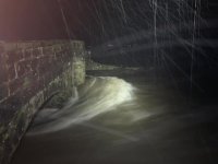
The Webcams went down because the RCD for Bridge End tripped, but I've attached a picture from later in the night (by John Helm) from just above the bridge.
The Webcams went down because the RCD for Bridge End tripped, but I've attached a picture from later in the night (by John Helm) from just above the bridge.
Attachments
gingerlycolors
New member
Is the Helwith Bridge Inn and YSS Old School House affected? I see the Ribble in Preston is high so I can imagine what it is like up in Ribblesdale.