mine entrance in the courtyard of Arkwright's Mill, Cromford.

davemowle

New member
Does anyone have any knowledge of a mine and /or Cave entrance in the courtyard at Arkwright Mill? The Arkwright's Society are trying to gather history before Arkwright including any mining. This seemed like an excuse to go exploring so myself and Owd Git are going in next week with some of the society members.
One of the locals cavers seems to think the mine breaks out on the face of Willersley Crag facing the river.
cheers
Dave
 

AR

Well-known member
I know the one you mean, I've looked at it several times when mooching round the mill and wondered how far it went. Although the crag is on the corner of one of the 25" Barmaster's maps, there's no vein marked so there may be nothing obvious in the Barmaster's records that was noted when the maps were being put together, though a close reading might turn up something.
 

Madness

New member
I've never noticed anything on the face of Willersley Crag when I've been climbing there. But there is a loose vegetated section in the middle of the crag where nobody climbs these days. There could be an opening behind the ivy I suppose.
 
I cover the history of those mine workings thoroughly in my forthcoming book on Matlock Bath because they are the east end of the Harp Edge Pipes, a major unexplored system of workings.They have a fascinating history and I have mentioned this to the Arkwright Society but they were not interested - they seem to share Arkwright's propensity for blocking off mine workings.


Arkwright blocked off all the workings in Scarthin Rocks (Willersley Crags or whatever they are called). There were about half a dozen shafts on top of the tor but he had them filled in. I looked quite thoroughly over the tops of the tors but could not see any trace of them, not even any minerals lying about. There are open entrances high up in the tor faces opposite Willersley Castle. These are mentioned in books about the climbs there but of course the Arkwright Society have prevented climbing on those tors. I would be very interested if anyone has ever managed to explore them. The pipe workings would be very small - mostly crawling.

The opening in the mill yard was a crawling way into the main pipe workings that was used to keep a good airflow through - essential when using firesetting. It could probably be dug open without too much trouble. I got thrown out by the Arkwright Society when looking at the entrances there.

The barmaster's maps for the Matlock Bath area are hopelessly inaccurate and incomplete but I have managed to sort out a reasonable plan of all the veins.
 

Madness

New member
There is a climb at Willersley called 'Pothole Wall'. I've done it a few times a long time ago. I don't know whether the hole is very deep or not. I can't even recall what the hole looks like. For it to connect to Harp Edge workings it would need to connect with a shaft to take you below the level of the A6. I don't know how far the water table is below the A6 here, but they could potentially be flooded.
 

AR

Well-known member
I suspect the formation of the Derwentwise partnership to promote the heritage aspects of the Derwent valley has made the Arkwrights a bit more appreciative of industrial archaeology outside of their specific field. There's already some great stuff come out of the partnership's lottery bids, such as the high-res lidar scans of the valley - see the 2017 edition of ACID (http://www.peakdistrict.gov.uk/__data/assets/pdf_file/0008/862496/ACID-Newsletter-2017-01.pdf).
 

davemowle

New member
Many thanks for your help, it looks like we may have an interesting trip tomorrow.
The Arkwright Mill manager has recently changed and is a keen climber /novice caver. This may explain the change of heart compared to those experiences a few years ago. Owd Git and I did a walk through video survey of the culverts a few months ago. The health and safety planning for that was pretty thorough but a necessary consequence of the size of the Arkwright Society and its insurance liability. They cannot have unplanned visits in a secure and locked down site.
Ric and I will report back if there is anything discovered tomorrow. I am sure we could arrange a further trip in for a better survey later in the year.
Dave     
 

pwhole

Well-known member
Good luck with that - all sounds very interesting.

History Trog - is there any progress with your book, just out of interest? There must be many people wishing to read it, including myself.
 

rob87

New member
Found a level near the mill carnt find anything on any maps but it heads away from the mill and is definitely a level some pictures
 

Attachments

  • WP_20171216_16_12_41_Pro.jpg
    WP_20171216_16_12_41_Pro.jpg
    360 KB · Views: 182
  • WP_20171216_16_12_07_Pro.jpg
    WP_20171216_16_12_07_Pro.jpg
    394.5 KB · Views: 188
A book that mentions the climb up to the holes about 15 feet below the top of the crags is Nunn, Paul, 1975. Rock Climbing in the Peak District. 304pp The climb is called the Gangue Grooves (gangue = vein mineral).

Originally, there was not a gap in the cliffs between Harp Edge and the Willersley Crags, it was a continuous ridge. The Harp Edge pipes weaken eastwardly, the most extensive workings being behind about the Scarthin Bookshop area. A reference I found only recently indicates that the main entrances were a series of cave-like openings in the hillside there, now hidden underneath the houses.

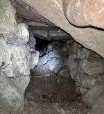
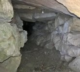
There was a legal case concerning the workings in Scarthin Rocks - a level behind the millyard was described as a "wind gate" and it was stated that Arkwright had had the shafts on top of the tor filled in with ashes, which at least would be easy to dig out. Perhaps they used ashes because they would be lighter to carry up there - no mine refuse would be available because the miners just dumped it down the cliff face. The miners used to have iron pegs up the cliff face to allow them to climb up to the entrances. I had assumed that the obvious entrance behind the mill yard was the wind gate but there may have been others - I do not recognise the photos shown by Rob87.

As regards the query about my book, although it sounds daft after so many years, I have had a major research blitz this last year that has brought in much new info' but when I have finished adding it all in and smoothing the text over, I shall have to think about publication again. I was talking this over with Jim Rieuwerts a couple of days ago because he has had works published privately, and they looked very good to me.

There have been postings about Harp Edge Pipes in the past. I have pointed out that the main shaft, c120 feet deep, was open in 1970 and may just be capped and covered over.
 

rob87

New member
It's easily overlooked area peoples eyes are focused on the mill opposite the entrance to the level and runs away from it it looks hard to find but it is really easy so see when you know were to look on mill road  (y)
 

Attachments

  • WP_20171216_16_10_09_Pro.jpg
    WP_20171216_16_10_09_Pro.jpg
    404 KB · Views: 166

Madness

New member
History Trog said:
A book that mentions the climb up to the holes about 15 feet below the top of the crags is Nunn, Paul, 1975. Rock Climbing in the Peak District. 304pp The climb is called the Gangue Grooves (gangue = vein mineral).

I've done 'Gangue Grooves' a few times but not for many years. It's next to 'Pothole Wall'.
 

ttxela2

Active member
pwhole said:
Good luck with that - all sounds very interesting.

History Trog - is there any progress with your book, just out of interest? There must be many people wishing to read it, including myself.

Indeed! I'm looking forward to it.....
 

AR

Well-known member
The PDMHS offer to publish the book still stands, and I'll do what I can to push this forward  -  Jim and Phil's Castleton book shows what we can aspire to.

Having a look on Harp Edge when the vegetation's down is on my to-do list, particularly having seen the lidar images which are great for focusing your search areas! I can't see a problem in PDMHS getting permission to use the images for the above book, since they really show just how heavily mined Masson Hill is!
 

davemowle

New member
We went in yesterday evening  with a few locals included the infamous Owd Git.
It is approximately horizontal for about 20 m before terminating at a shaft.
The narrow shaft looked like a hauling shaft that must have been capped at top of Willersley crags. The Arkwright Society have handrails and information boards up there with plenty of visitors about so may have been the ones to cap it although they have no record of doing it. We climbed the shaft as far as the cap at 13 m, there were slates and rubble wedged across the entrance and plenty of roots so couldn't have been far off.
The shaft also descended 7 m below the level to what we assumed was the level of the Derwent. It was heavily picked as it disappeared into the water and I watched a rock disappear at least 2-3 m below water level. It was crystal clear and i firmly believe kept going down. Without any mine experience (and happy to be corrected) i assume this meant it was a pumped mine?
The Mill manager is happy to get another limited visit organised if someone with more experienced eyes wants a look or survey.
Please let me know.
Dave
 
I am surprised and interested at the description of the workings found by Dave. Any drill holes? Any sign of flowing water in the shaft? Somewhere there should be a branch of the Bonsall Fault - the Harp Edge is a complex Horst feature, thrown up between branches of the fault. I will have to look again at Nick Butcher's interpretation of the geology round there. Any pumping would be just rag and chain pumps or simply buckets. They were very primitive small mines.

One aspect that fascinates me is that there was a cache of Roman coins found in 1795 when quarrying at Harp Edge. The mines there are recorded before 1600 and they had natural cave-like entrances above Water Lane in Harp Edge. It would be an obvious site for Roman mining.

The main run of pipe workings should be similar to those on Houghton Pipe in Brogdale Mine along the Clatterway up to Bonsall - long runs of low crawls, no real chambers and only moderate amounts of lead ore were obtained.

I am grateful to Adam for pointing out the ref to the laser survey - news to me and very useful for minor veins. Hope one can get other images besides those published in the ACID newsletter.

Of course, I would offer the book first to Pudhams and I do not want any royalties at all - if they can make a bit of profit from it, that's great.
 
  • Like
Reactions: 2xw

davemowle

New member
Thanks History trog.
Your description of the Clatterway mine perfectly describes The Arkwright level, IE low and awkward with no chambers. The only slight headroom along the crawl was were they had worked the roof for ore.
We were crawling over deads but could see the sides of the mine widening indicating a better width lower down.
Along the level were many side workings, none wide enough to suggest a passage but wide enough to have been picked out to arms length and showing the fractured rock you describe above. All side working were chocked full of deads.
There were a few drill holes along the crawl. Ric thought they were plug and feather, hand tooled to open up the tightest parts of the crawl as the floor of the mine raised. 
There were no obvious water driven parts seen in the mine.
The whole crawl was heading for Harp edge, there was a dead filled continuation at the shaft that we could not explore. It looked similar to the crawl in size and direction so may have linked through?


AR

Well-known member
In relation to water levels in the shaft, is that area one of the ones where the river level has been raised since the 18th century? If so, there might be a flooded lower level.

The LIDAR images cover quite a long length of the Derwent valley as I understand.
 
On thinking about it, the flooded shaft is a puzzling feature from a mining point of view and I think it quite probable that it could have been sunk for a water supply. There used to be the Hill's brewery in the Mills there, c1890, as I recall, and they would have required a good supply.

It is similar to the working in Allen's Hill at Cromford Market Place where a flooded sump was used to supply water to the adjacent businesses.
 

davemowle

New member
I went onto the top of Willersley crags yesterday and found the very obvious shaft entrance, IE a 4 m round 1 m deep hollow with a fence round it.
From the top you can see where the mine entrance is, the shaft hollow, the top of the climb 'Pot hole wall' and harp edge. I hadn't realized they were a near perfect straight line so i assume follow a geological line and could corroborate the connection mentioned earlier.
Ric and I will abseil down to the Pot hole of pot hole wall to see if it goes anywhere.
Will report back next week. 
 
Top