Polish abbreviated surveying method

Rad

New member
Earlier in January CUCC met with polish cavers from Wroclaw Uni in tatra mountains.
Quite a few things are different in Poland apart from general temperature.

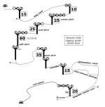
Polish caves use abbreviated rigging guides that combine plan and rigging topo,
while using symbols for various relevant information in a cave.

Well prepared surveys like this were printed on A5 pieces of paper
and were still convenient to use even for large multi junction multi pitch cave systems.

Multitude of such guides/rigging topos can be found here: http://www.kktj.pl/szkice/szkice.html
In attachment translated symbol description, and one more familiar cave.

Rad
 

Attachments

  • legend.JPG
    legend.JPG
    62.9 KB · Views: 780
  • swinsto.JPG
    swinsto.JPG
    49.6 KB · Views: 171

Tommy

Active member
Cool!

Around a year ago I was wondering if orienteering control description holders could be used for some sort of system of simplified navigation symbols for caving.

Looks like I was beaten to it and surpassed!
 

Attachments

  • HPIM1211.JPG
    HPIM1211.JPG
    60.1 KB · Views: 173

TheBitterEnd

Well-known member
Good stuff, I have often thought that we needed something equivalent to an Ordnace Survey map for cave navigation and that looks like a start.

By "Ordnace Survey" map I mean a map where key routes take priority over exact positioning of features, useful navigational points are marked by symbols for clarity, etc. Obviously cave surveys are the right thing for digging and exploration but for navigation it would be more handy to know, for example that you should head east, pass the big stal after about 20m and then drop though a hole in the floor.
 

SamT

Moderator
What Topimo said..

I've taken up Orienteering a bit of late as my lads are keen and enter into a lot of the schools events.  I'm really enjoying the map reading aspect, (and my knees are hating the running bit).

The polish system does seem very akin to the orienteering symbols, and Tops suggestion of an arm holder (I just bought one exactly as above at the weekend for orienteering)  seems like a great idea for having some sort of topo for the cave you're navigating. Rope lengths, number of bolts/devs. etc.

Hmm - you've got me thinking.  I might sit down and see if I can do the giants round trip or some such, and created an orienteering style topo for it.
 

Tommy

Active member
The polish bolt symbol is the same as the climbing Topo style, I suspect other features may relate but I haven't looked.

What an excellent BEC resource, thank you!
 

Rob

Well-known member
It'd be a fun challenge to backward navigate them. i.e. to see a topo and to guess what cave it is of.....
 
Top