Tommy
Active member
A Brief Bimble in Belgium - Trou des Furets (Ferret's Hole)
7th of October 2017 (I forgot to write this up until now).
On a working trip to Belgium I decided to pop in and see the local university caving club for an evening at their stores and clubhouse (VERY neatly organised I must say, complete with in-house rope tester). The club is known as SPEKUL (Speleo KU Leuven) and is around the same age as SUSS, also a mountaineering club spin off. They have their own branded beer that I can wholly recommend. In fact, it was after several bottles of that very liquid that I found myself booked on to a weekend trip with Hans, Lucie, and Leonie.
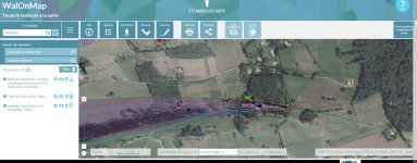
From Leuven, many of the caves are around an hour's drive away, as they are scattered across a limestone band that sweeps its way across the country. With my single pair of non-office shoes for the fortnight, no SRT kit, no kneepads, and the tattiest XL AV oversuit I have ever borrowed, my kit bag was looking rather light. Halfway through the drive, Hans turned and said, "So I assume we are all okay with insurance and everything?", I hadn't even considered it! But he seemed to decide that simply going caving was better than turning the car round or leaving me by the side of the motorway.
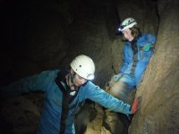
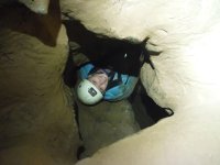
After a short walk through long wet grass and into a wooded area, we located the rather unused looking entrance to the cave, full of leaves, cobwebs, bits of wood, and other woodland detritus. Once cleared, a slippery descent meant for fun straight out of the gate. The small cave was rather vertical in nature despite having zero ropework, and our path seemed to rise and fall through rift chambers and small pots like a roller-coaster, apparently this was fairly representative of much of Belgian caving (small horizontals).
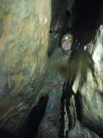
One such rift passage contained 'the feature of the cave'. With a gnarly chain to assist, we ascended through an increasingly constricted squeeze. Incredibly fun and awkward caving, the prospect of slipping, becoming wedged, and being beyond reach of the much-appreciated fixed proved distracting until reaching the top anchor. This is probably exaggerated now by memory, but it didnt' look too far off something like a three inch rusty wood screw with a washer holding the chain on, it probably used to be bigger before the degradation set in...
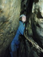
In contrast to the small, muddy passages that were de rigeur for the cave, the terminal chamber was around 20m high, and fairly wide. Most of the wall was clean washed, and this facilitated two rather engaging climbs.
Grasping the edge of a large detached spike/pillar enabled a swing into an offwidth slot in the wall, arm-barring & chicken winging upwards and inwards, whilst standing on the initial spike/pillar. This led to the eyehole which I could just about get my shoulders into, the challenge really was the lack of leverage from any other features! Sadly the tube quickly tightened to a very impractical dig face.
The second climb was one of the boldest I've done in a cave in terms of height, but didn't feel serious at all due to the excellent flake and spike jugs, and the ease of bridging in the corner. After some 10 metres, I decided to back off, the thoughts of insurance issues outweighing the desire to see the roof of the chamber (there was no obvious continuation to climb to at this point), this was purely play I told myself (...Mild Severe 3c).
These climbs were conducted with a surprisingly real sense of the unknown, due to the lack of information I had been given about the cave, and being on a slightly impromptu trip underground abroad. I was under the impression that the cavers who were kindly taking me underground knew the location and not much else, i.e its exploration and digging history. I have not conducted further research so as to preserve the memories.
Access issues mean that survey data and cave locations are not openly shared, ultimately this means that the data for many caves has disappeared as paper records have expired/disappeared.
This to me sounds a sorry state of affairs, and I hope that we continue to share information as well as we do in the UK (though we still have things to improve on).
To conclude the 2h trip we of course went to a Belgian bar, I believe I had a Chimay Blau...
7th of October 2017 (I forgot to write this up until now).
On a working trip to Belgium I decided to pop in and see the local university caving club for an evening at their stores and clubhouse (VERY neatly organised I must say, complete with in-house rope tester). The club is known as SPEKUL (Speleo KU Leuven) and is around the same age as SUSS, also a mountaineering club spin off. They have their own branded beer that I can wholly recommend. In fact, it was after several bottles of that very liquid that I found myself booked on to a weekend trip with Hans, Lucie, and Leonie.
From Leuven, many of the caves are around an hour's drive away, as they are scattered across a limestone band that sweeps its way across the country. With my single pair of non-office shoes for the fortnight, no SRT kit, no kneepads, and the tattiest XL AV oversuit I have ever borrowed, my kit bag was looking rather light. Halfway through the drive, Hans turned and said, "So I assume we are all okay with insurance and everything?", I hadn't even considered it! But he seemed to decide that simply going caving was better than turning the car round or leaving me by the side of the motorway.
After a short walk through long wet grass and into a wooded area, we located the rather unused looking entrance to the cave, full of leaves, cobwebs, bits of wood, and other woodland detritus. Once cleared, a slippery descent meant for fun straight out of the gate. The small cave was rather vertical in nature despite having zero ropework, and our path seemed to rise and fall through rift chambers and small pots like a roller-coaster, apparently this was fairly representative of much of Belgian caving (small horizontals).
One such rift passage contained 'the feature of the cave'. With a gnarly chain to assist, we ascended through an increasingly constricted squeeze. Incredibly fun and awkward caving, the prospect of slipping, becoming wedged, and being beyond reach of the much-appreciated fixed proved distracting until reaching the top anchor. This is probably exaggerated now by memory, but it didnt' look too far off something like a three inch rusty wood screw with a washer holding the chain on, it probably used to be bigger before the degradation set in...
In contrast to the small, muddy passages that were de rigeur for the cave, the terminal chamber was around 20m high, and fairly wide. Most of the wall was clean washed, and this facilitated two rather engaging climbs.
Grasping the edge of a large detached spike/pillar enabled a swing into an offwidth slot in the wall, arm-barring & chicken winging upwards and inwards, whilst standing on the initial spike/pillar. This led to the eyehole which I could just about get my shoulders into, the challenge really was the lack of leverage from any other features! Sadly the tube quickly tightened to a very impractical dig face.
The second climb was one of the boldest I've done in a cave in terms of height, but didn't feel serious at all due to the excellent flake and spike jugs, and the ease of bridging in the corner. After some 10 metres, I decided to back off, the thoughts of insurance issues outweighing the desire to see the roof of the chamber (there was no obvious continuation to climb to at this point), this was purely play I told myself (...Mild Severe 3c).
These climbs were conducted with a surprisingly real sense of the unknown, due to the lack of information I had been given about the cave, and being on a slightly impromptu trip underground abroad. I was under the impression that the cavers who were kindly taking me underground knew the location and not much else, i.e its exploration and digging history. I have not conducted further research so as to preserve the memories.
Access issues mean that survey data and cave locations are not openly shared, ultimately this means that the data for many caves has disappeared as paper records have expired/disappeared.
This to me sounds a sorry state of affairs, and I hope that we continue to share information as well as we do in the UK (though we still have things to improve on).
To conclude the 2h trip we of course went to a Belgian bar, I believe I had a Chimay Blau...