Maskill/Maskhill

adam

Member
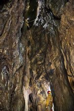
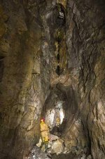
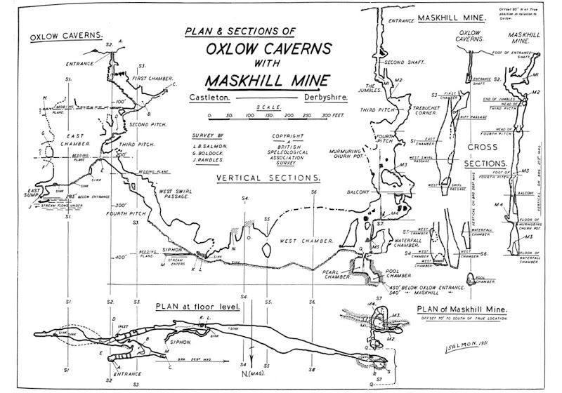
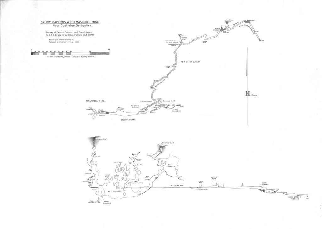
Maskhill or Maskill - that is the question.

The two spellings seem to be used interchangeably almost everywhere I look, including the Peak District Caving Info guides and the UKCaving Wiki. I'm starting to think there's some sort of conspiracy afoot. It vexes me. I'm terribly vexed.

Can anyone shed some light on this? What does the survey say? Is the mine named after someone or something or is it a made-up word? What does the helpful direction sign on the Oxlow entrance say? What do the Derbyshire caving intelligentsia say?


Brains

Well-known member
TBH I have no definitive knowledge, but always felt it should have the "H" included. If the name has some antiquity it probably has a variety of spellings anyway. Perhaps Pwhole has seen some old maps or documents that help?
 

pwhole

Well-known member
From the Barmaster's book held in the Derbyshire Record Office (DRO B/L 31):

"Nicked 8 stowes on a vein called Maskhill belonging to Elias Rose of Castleton" (24/08/1790).

also

"Gave the ground to Robert Barber of Mam. He set 19 stowes on the vein." (13/09/1790).

8 meers and then 19 meers less than a month later has always intrigued me, as that's a vast horizontal measurement for the place, which is essentially all contained within one meer nowadays. It doesn't guarantee it was actually mined of course, but it least suggests that they felt the vein continued. The trouble is, it's likely the mines were worked well before that date, but no records survive, and these shreds apparently are the only clues remaining as to what went on. My suspicion is that both Oxlow (Rickety Mine) and Maskhill were probably relatively rich, easy mines for the first adventurers, as most of the vein cavity had already been washed out. So most of the galena would have been on the floor, possibly buried in sediments, or just lying around in lumps. After that, subsequent owners would have been just scratching around for bits.

From looking around the vein exposures in both sites, it seems to me that actual vein workings are quite limited, with only small portions removed completely, and the rest being worked-out pockets in the (usually steep) forefields. Given the vertical nature of the Maskhill workings, it must have been quite a faff to install stemples across the voids for what can't have been much more than a few days work. Of course, there may be far more workings in there than are currently known about. Not many people actually explore Maskhill, possibly on the assumption that it was all done long ago. That may be so, but they often missed stuff, or didn't finish it off, as we're constantly finding out! And they didn't have cordless drills back then either.

The images below show some of those worked-out pockets in Maskhill and Oxlow West Chamber.
 

Attachments

  • _IGP9104_sm.jpg
    _IGP9104_sm.jpg
    67.8 KB · Views: 252
  • _IGP9135_sm.jpg
    _IGP9135_sm.jpg
    48.4 KB · Views: 310

Rob

Well-known member
pwhole said:
...Not many people actually explore Maskhill, possibly on the assumption that it was all done long ago. That may be so, but they often missed stuff, or didn't finish it off, as we're constantly finding out! And they didn't have cordless drills back then either....
I was thinking exactly this at the weekend. And not only for finding new mine, Maskhill's a fine contender for finding any upstream development on the Pilgrim's Way bedding....
 

Brains

Well-known member
The vein shows major evidence of working from beyond Rowter Farm in the East to past the Giants access road in the West to nearly as far as P8, with only Oxlow and Maskhill known to go deep... plenty of scope for more workings on the rake, some of which could be deep!
 

adam

Member
Thanks all, I'm no longer vexed. I do like hearing these snippets about the history of the mines from back int' day. Is it true that if you find and extract 60 lbs of ore from a mine, you can claim the right to the title of the mine at the Magistrate's Court in Buxton?
 

AR

Well-known member
There is still a Barmaster in the Peak and the working of lead and ownership of title is governed by the 1851 and 1852 acts of Parliament which formalised the Barmote Court system. The delivery of a freeing dish of ore is now not physically required though it comes out for the look of it on odd occasions, such as the title consolidation at Treak Cliff a few years ago.

However, before anyone starts thinking about claiming title to a mine, bear in mind that many titles are now held by the large mineral working companies who won't take kindly to an attempt to nick one of their possessions (the Barmaster serves notice on the last recorded owner to put the mine in workmanship within three weeks), also that by claiming a title you are declaring intention to work which may attract the attention of the Mines Inspectorate and result in questions about competency to do so, and that you'd become liable for making safe any shafts or adits in the title. Best left alone unless you know what you're doing....
 

pwhole

Well-known member
And here's what a dish of ore looks like, taken on that very day at Treak Cliff - with John Turner dressed as a miner, groaning under the considerable weight in the last shot. Note the dish has 'ER 1901' stamped on it, so was made just after Queen Victoria had died.
 

Attachments

  • _IGP4040_ex_sm.jpg
    _IGP4040_ex_sm.jpg
    29 KB · Views: 206
  • _IGP4036_ex_sm.jpg
    _IGP4036_ex_sm.jpg
    46.8 KB · Views: 194
  • _IGP4066_ex_sm.jpg
    _IGP4066_ex_sm.jpg
    47.9 KB · Views: 221

AR

Well-known member
Going back to the original topic, while doing my quick blast through on Saturday I spotted several points where there there blanks on the surveys and thought "surely someone must have looked at that", in particular the stemple run  just before the low bit leading to the main west chamber. Maybe it is the case that everyone assumes someone must have done it but in fact, no-one has yet got round to it!

Regarding the spelling,  the old records can be quite erratic when it comes to some of the more unusual names; I've seen several renderings of "Faucet" and "Crowshaw" in original documents.  Personally, I think using Maskhill is the most appropriate in the 21st century.
 

pwhole

Well-known member
The only proper survey of Maskhill that I've seen is Les Salmon's old one from about 1959, when all the internal drystone winzes were still in place in Oxlow. Sadly the Giants/Oxlow survey that's commonly available only has the plan on, which is not much use for Maskhill! I always find elevations far more useful.
 

Rob

Well-known member
pwhole said:
The only proper survey of Maskhill that I've seen is Les Salmon's old one from about 1959...
I think you mean this one:
oxlow%201_zpsafx6w4dv.jpg


The only other one i've seen with Maskhill in elevation is the EPC one from 1976, cunningly from the other direction:
Oxlow_zpsler7vnvi.jpg


pwhole

Well-known member
That's the one. Though even that might be an update, as the one I've seen (at the Chapel, I think) still has little drystone shafts drawn in on the 2nd and 3rd pitches in Oxlow. There is a note in an old BSA report saying (I'm paraphrasing) that if a lot of the old man's rubbish were knocked down, the place would be a lot safer and more fun. The second survey I have seen somewhere before, but dunno where. The Great Aven looks fun.
 

AR

Well-known member
The second survey was posted on a thread here ages ago, I think by the one and only Dr. Beck IIRC - I refound it and printed it out to take on Saturday. Interesting that both show the areas at the top of the stemple run as unexplored; I wonder if people thought it wouldn't go anywhere other than the high avens in the west chamber?  Possibly not the case as one thing that really struck me about both shafts was that they seemed to have been deliberately sunk to hit the natural at opportune points; if that's the case then where was the original point of discovery by the miners, I wonder :-\?
 

pwhole

Well-known member
Halfway down the pitches (I can't remember which one exactly, but it's below Trebuchet Corner and you land on an easy slope), you can climb onto a ledge in the opposite direction to the next pitch down - beyond the ledge is a large floor-hole, and beyond that I'm sure I saw a passage going off into the distance, on the only time I looked. I think the floor-hole may have been an alternative route to the bottom in ye olden days of Les S and co and maybe even later. I'm sure Chocolate Fireguard told me about this once. Anyway, I too suspect there's more to be found in yon Maskhill. As AR mentions, the holes in the far wall may go somewhere else too.
 

A_Northerner

Active member
pwhole said:
And here's what a dish of ore looks like, taken on that very day at Treak Cliff - with John Turner dressed as a miner, groaning under the considerable weight in the last shot. Note the dish has 'ER 1901' stamped on it, so was made just after Queen Victoria had died.

Is he dressed as a miner? I have a few hipster friends who dress like that nowadays!

It's quite surprising how infrequently places like Maskhill get explored because people assume that they've already been looked at - maybe next time I'm down there I'll take a good look and see if I can find anything interesting.
 

AR

Well-known member
That's later 19th century miner's costume, if you buy a copy of the Castleton book (subtle hint) then you'll get a good copy of a picture of what the late 18th/early19th century was wearing, and Daniel Defoe described the late 17th century miners as wearing leather clothes.
 
Top