Burton Mine, Dirtlow Rake

langcliffe

Well-known member
Forgive me, but I am speaking from a position of total ignorance of anything south of Skipton...

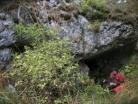
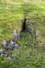
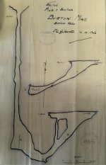
Amongst the Nobby Clarke collection of photographs there are a number of surface shots of a descent of Burton Mine, on Dirtlow Rake, taken in April 1946. However, I can find no reference to Burton Mine on the web, or in my meagre collection of Derbyshire books.

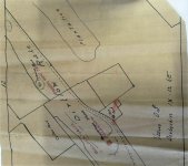
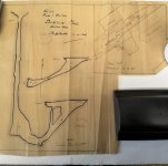
Would someone be kind enough to tell me a little more about Burton Mine? In particular, has the site disappeared, or has it now got a different name?
 

pwhole

Well-known member
Hahaha - join the club! I've been trying to work out this puzzle for ages. I've shown the photos to Jim Rieuwerts who has no knowledge of that mine name either. From my walks up there, I'm guessing that it's either Prince or Nall Grove - between How Grove and Hollandtwine. The other shafts don't really tally with the scraps of landscape visible in the background - however, there was a lot of landscaping done up there, and the site is clearly very different to what it was in the 1940s.
 

langcliffe

Well-known member
Thanks, pwhole - that is very useful. I'll ask for a library search in the literature of the time, as we have the date.

If anybody else has anything to contribute, please feel free.
 

AR

Well-known member
I've had a look over the scan I have of a 1953 air photo but there was no obvious hole looking like this on Dirtlow Rake I could see. This was taken off a not-that-good print from Nellie Kirkham's collection, at least not compared to what you get if you buy air photo prints these days. The best chance of pinpointing the location would be from the 1948 flyover (all images I've seen from this run have been good quality),  if anyone near Swindon fancies going and looking at the national collection - https://historicengland.org.uk/images-books/archive/collections/aerial-photos/
 

langcliffe

Well-known member
Thanks, AR. The British Caving Library has some RAF photos of Dirtlowe Rake, but there isn't a date associated with them in the catalogue. Probably more to the point, having never knowingly been on Dirtlowe Rake I wouldn't know what to look for!
 

pwhole

Well-known member
All the remaining shafts have been grilled now, and most are up on the top of the south flank of the main opencuts, whereas this seems to be at the bottom of one - or at least below the main surface line. The main shaft in the 'Nether Dirtlow' enclosure, known at one point as Ashton's Mine has a big 'funnel' top as this one seems to have, so it's feasible that it is this one as the surface has been totally altered in recent times. I've got a poor shot through the grille, but it doesn't give much away - we've been meaning to drop this one for ages as it does have an access hatch, though the bolts are well rusted now. I've been told by someone who's dropped most of these before they were grilled that there's not actually that much to explore. The mines at the top end of Dirtlow were fairly unproductive - until the vein split at Hazard at least. I just can't work out where they got the 'Burton Mine' name from, as it's not listed anywhere.

Maybe there was a fluorspar gangster at the time called Burton who gave them permission to enter 'his' mine but it wasn't really his. As that's happened to me not that far away ;)
 

pwhole

Well-known member
I've realised I made a mistake on Prince or Nall Grove - both of those were downhill (NE) of How Grove, not above it - though I still suspect that it will be one of these two.
 

AR

Well-known member
Having pulled out my copy of Mining History 15:2 (the How Grove excavation report), the titles between How Grove and Hollandtwine were Bennett Grove and Bullock Grove.
 

pwhole

Well-known member
Maybe 'Burton' was some kind of misunderstood mixture of the two names. The weird thing is, Eli Simpson was involved in all this stuff and knew the area well, so it's a puzzle really. That said, a few of us found some pipe workings near Pindale Quarry recently, just downhill, that weren't documented on any map, even the Barmaster's, with a big entrance - but it can only be seen from one position. And the mine entrance slap-bang in the middle of Michill Bank, just around the corner toward Castleton, on an obvious vein, isn't mentioned anywhere either, and I only know of one person that had ever visited it before. It's not a huge site, but it's glaringly obvious from the Hope-Castleton road - amazing these things can slip through. Both below.
 

Attachments

  • IMG_3805_sm.jpg
    IMG_3805_sm.jpg
    303.9 KB · Views: 149
  • _IGP7393_sm.jpg
    _IGP7393_sm.jpg
    341.2 KB · Views: 147

Jenny P

Active member
I have just found a survey of Burton Mine.  It was in a stack of material bequeathed to BCRA from Doug Nash & John Beck's House after John's death, and hence it came to BCL.  This is an original survey, on what looks like brown wrapping paper, and it is dated 10 April 1946.  Done by J.C.Gilbert and stamped with Eli Simpson's BSA stamp.

It is a "sketch plan and section" at a scale of 1 inch to 20 ft. and also includes part of a surface map, copied from the OS 1:25,000 Derbyshire IX.12. SE (which shows the field boundaries, dew ponds, etc.) showing its exact position on Dirtlow Rake.  However, someone else has written in red ink a correction to the name "Burton Mine" and replaced it with "Bradshaw" and has also labelled in red "Bullock Grove" and "Prince's West End". 

Also marked on the same map is "Furniss Mine", which is on Dirtlow Rake to the north eat of "Burton Mine".

We will try to put a photo of the survey up shortly.
 

yrammy

Member
Here are a couple of photos of the survey just mentioned by Jenny Potts.  I cant improve on these whilst at the library but can do better shots later if anyone would like me to.
Thanks
Mary
 

Attachments

  • IMG_20201014_113550 (2).jpg
    IMG_20201014_113550 (2).jpg
    1.1 MB · Views: 152
  • IMG_20201014_113535 (2).jpg
    IMG_20201014_113535 (2).jpg
    915.6 KB · Views: 172
  • IMG_20201014_113543 (2).jpg
    IMG_20201014_113543 (2).jpg
    1.3 MB · Views: 150

Mrs Trellis

Well-known member
According to the map in Ford & Rieuwerts Lead mining in the Peak District p66 Bradshaw Rake is the sw continuation of Dirtlow Rake.

The left then right of the track looks like where the legend "Flourspar Opencast" is on the map.

"Dirtlow Stone Mine" including Bullock Grove and Bennett Grove seem to marke the spot on this excellent interactive map.

https://www.mindat.org/loc-242202.html
 

pwhole

Well-known member
Right, that's cleared it up then - it's gone! It's buried under the backfill of the fluorspar opencast. Thanks to that map, the field boundaries can be matched on Google Earth. I wasn't far off with Prince then ;)
 

langcliffe

Well-known member
Well done, Jenny and everybody!

Having had a look at Google Earth and worked out where Dirtlow Rake was (ignorance knows no bounds in our household), I place it as shewn below. Does that seem more-or-less right?

burtonmine.jpg
 

pwhole

Well-known member
I'd say that was pretty much spot-on. Sadly my Dirtlow Rake Barmaster's overlay ends just to the NW, but there'll be a reference to the name somewhere. Bullock and Bennett Grove are much better-known names than Burton.
 

langcliffe

Well-known member
Well, that was a marathon, but I think that we cracked it. Thank you everybody for your help. I have added the surveys to the page of photographs in the archive to give them some context:

https://archives.bcra.org.uk/archive.php?level=document&collection=clarke&document=burtonmine
 

Mrs Trellis

Well-known member
pwhole said:
Right, that's cleared it up then - it's gone! It's buried under the backfill of the fluorspar opencast. Thanks to that map, the field boundaries can be matched on Google Earth. I wasn't far off with Prince then ;)

Gone but not forgotten ...........now.
 

AR

Well-known member
pwhole said:
I'd say that was pretty much spot-on. Sadly my Dirtlow Rake Barmaster's overlay ends just to the NW, but there'll be a reference to the name somewhere. Bullock and Bennett Grove are much better-known names than Burton.

Probably mentioned somewhere in here  - https://pdmhs.co.uk/MiningHistory/Bulletin%2016-6%20-%20A%20Gazetteer%20of%20the%20Mines%20within%20Castleton%20and%20Hope%20Liberties.pdf

The hole may have been filled in by 1961 when Harry Chatburn wrote this paper for an early PDMHS bulletin as it's not mentioned, but it does mention sparring work in progress - https://pdmhs.co.uk/MiningHistory/Bulletin%201-7%20-%20The%20Surface%20Remains%20on%20Dirtlow%20Rake.pdf
 
Top