Matlock Bath

braveduck

Active member
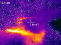
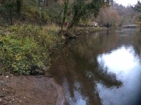
I was in Matlock Bath at the weekend .Walking along the riverside walk I noticed that the River Derwent was as low as I have ever seen it . Just opposite the Mining Museum is section of the walk with railings which end next to a small beach.
Running across the beach was a small stream coming from the vegetation under the path.
I decided to check if it was thermal water .Yes big difference between the stream and the river water .
Just as I was doing this a family arrived,somewhat curious as to what I was doing .
Having explained, they tried the temperature test for themselves .They were gobsmacked .
I think I made their  day.
Fortunately nobody fell in the river while this was happening .
When the river is at normal height I do not think this rising will be visible at all.


Boy Engineer

Active member
The 'rising' is Jackdaw Sough. I'll try and upload a picture I took last year with a thermal camera, which gives an indication of the temperature difference. I had a poke at the outfall about a month ago with my 'SoughCam?', a lorry reversing camera suitably waterproofed and mounted on a set of tent poles, but couldn't get more than about a metre under the bank. History Trog may well be along with more information when he next logs in. The river is higher now than when the Sough was driven thanks to (but not from our perspective) the Masson Mill weir, so I suspect that access from this point may be problematic.
 

Boy Engineer

Active member
Here are the pics.
 

Attachments

  • IMG_0353.JPG
    IMG_0353.JPG
    68 KB · Views: 139
  • IMG_0602.JPG
    IMG_0602.JPG
    52 KB · Views: 145
There is the potential for getting into some very interesting workings here.
From the draft of my Matlock book, I extract the following:
In the 1950s, an old miner told how to find the mine entrance in the Lovers? Walks:
"Take the first path up the rocky slope past the bandstand. So far up turn off into the wood about 10 yds. and look for a depression (look for 2 or 3 elm trees from one root), in the depression you will find two loosely gobbed up gates. Take the right hand one and you will come to a 4 ft. drop, proceed on for about 200 yds. and you will notice on the right hand side an old type miner?s pick. Take a ladder with you and you can get right through to ?Bullistree Mine?, Cromford. On the way through notice the roof a classical example of the ?Old Mans? architecture arches, like horse?s ribs [i.e. sweeping pick marks]. Also notice the stalactites, lovely curtains of them.
This unlocated entrance was perhaps on the middle of the three Moletrap Veins nearly one hundred yards downriver from the bridge to the railway station. This led into an extensive coffin-gate sough along Jackdaw Vein into the Moletrap Veins that was reputedly entered from Station Quarry during the 1970s."


Be warned that nobody seems to have been able to find a way in. I have had a good look but perhaps ought to have another bash.


mch

Member
There seem to be some openings still in Station Quarry. Has anyone had a look at these in recent times?
 

SamT

Moderator
I'm impressed with the Flir image.

You do have to be very careful when interpreting thermal images.  Especially on something like water, as most of what you see on there is reflected heat, not actually the temperature of the water.

That's why i'm impressed its picked up the warm water coming from the sough, which is quite obvious.
 

Boy Engineer

Active member
Alex,
Yes, it's the little FLIR with a Lightning connector. I find it easier to use with my iPad as the phone case gets in the way.
There are lots of 'hot spots' along that section of the Derwent, but the Jackdaw one is the most impressive on the east bank.

Mike,
We had a look around Station Quarry mine about 20 years ago, certainly before the rifle club were in residence. Unfortunately this was prior to knowing about the workings that Roger refers to. When life slows down (just mid house-move) I'll put some feelers out.
 

AR

Well-known member
I found what I think might be the depression referred to a couple of years back but as I had the dog with me I didn't have a serious look. If people do go searching for this, be mindful that it's close to the footpaths in a public park before starting a dig....
 
I guess the most effective way of locating these hidden entrances would be to search the area when there is a good covering of snow. The warm air rises from the highest entrances in winter and in this case, the thermal water underground would increase the effect and make snow melt more conspicuous,
 

mch

Member
Drove over to Matlock Bath today to take some readings of the water emerging from Jackdaw Sough. With an air temperature of 15.6 deg C and the temperature of the river water at 12.9 deg C, the water emerging from the sough was 18.3 deg C. The pH was 7.47 and the EC was 903 microsiemens. I thought it might be interesting to take some readings at Bullestree Sough for comparison in view of the probable connection but as I thought may be the case the river bank was too overgrown at present to locate it. Another little job to go on the post-Christmas list.
 
The outflow from Jackdaw Sough has been recorded at various times from 17.4 to 20.5 C. I think it most likely originates from Bacon Rake in the Heights of Abraham, flowing under the river.
The nearest thermal source on the east bank is that in Hagg Mine (just north of Willersley Castle wall, entrance walled off in a large cutting, water issues in riverbank).
There was also thermal water in Nether Hagg Mine (in the big rift by the weir opposite Wapping Mine) and in the associated Bullacetree workings. The outflow from Bullacetree Level  (in riverbank below Bridge House at Willersley) has been contaminated by seepage from farming. The outflow from the Bullacetree pumping levels further east originates from the shales and I would imagine that this does not have a thermal component.
The Hagg and Nether Hagg thermal sources reputedly originate from Ball Eye.
 

Tripod

Member
This conversation regarding connections appears to relate to what I was told many years ago about a level at Cromford which, as the saying goes, "went for miles" and sounds now like Bullacetree Mine. More recently but still  good few years ago I as told of a level in the cliffs, south of Lovers Walks and accessible only by abseiling in from above, which again "went ------". Discovered by climbers not cavers and I did not take up the offer to take a look at the time.
 
Top