I wonder what this was

Mark

Well-known member
I came across a painting by Harry Hepworth Allen (Sheffield) 1894 - 1958 - and instantly recognised it as the top end of Middleton Dale looking towards Foolow

There is a bloody great hole shown in the floor of the dale, artistic licence or was there something there.


Attachments

  • harry-epworth-allen-derbyshire-walls.jpg.png
    harry-epworth-allen-derbyshire-walls.jpg.png
    860.7 KB · Views: 328
  • Screen Shot 2020-02-11 at 13.18.24.png
    Screen Shot 2020-02-11 at 13.18.24.png
    1.9 MB · Views: 175

mikem

Well-known member
Probably for effect, but cave registry does include some lost holes (put location you think into search & will show everything within 2km - N.B. not all older grid refs are accurate):
https://registry.thedca.org.uk/registry/registrysearch.php

Although it looks like mining - will need to check their records as well (a lot of shafts on Mendip were filled in during middle of last century).
 

Chocolate fireguard

Active member
Yes it does have the look of that view (where Middleton Dale changes to Linen Dale?), but the 25 inch map, found on this website
https://maps.nls.uk/os/6inch-england-and-wales/
would have been done about the time when HEA was born and only shows a couple of what might have been mineshafts, or might have been dewponds, in that area.
SK19547642 & 19677645
The Bing hybrid map shows faint traces still on the ground.
 

mikem

Well-known member
The hill profile on left of photo matches, but suggests the painting wasn't quite from that angle.
 

Mark

Well-known member
mikem said:
The hill profile on left of photo matches, but suggests the painting wasn't quite from that angle.

Screen shot from Google Maps, Tideswell Lane runs across the middle of the picture and the two little walls just between there and the hole gave it away for me, as I pass these most days walking the dogs, and have no idea why they are there
 

mikem

Well-known member
Well, in the painting it looks like a sheep pen (but that would normally be in corner of field), so could it have been an engine house or miners' shelter?

It was painted from further right than the photo spot, as then most of the walls line up. The fields in the valley floor have been landscaped - they're much flatter now, so nothing to be seen.

The 1880 map doesn't even show the enclosure, whilst turn of century ones show nothing near it that could be that hole, & nearest feature on aditnow is Lousley Quarry.

How does this one relate to reality? (& name should be Epworth):

harry-epworth-allen-0ff0b8c8-8b15-4601-9ce2-e84a170bfb7-resize-750.jpg
 
I don't think the photo is taken far enough back.  The road at the bottom of the picture is the A623 Middleton Dale.  Therefore the hole is south of that. 

On StreetMap there is a 'Shaft Disused' showing  https://www.streetmap.co.uk/map.srf?x=419777&y=376111&z=115&sv=419777,376111&st=4&ar=y&mapp=map.srf&searchp=ids.srf&dn=777&ax=419777&ay=376111&lm=0

There isn't anything showing up on Google Maps though https://www.google.com/maps/place/Foolow/@53.281546,-1.7038988,403m/data=!3m1!1e3!4m5!3m4!1s0x487a295dd1a9514d:0xf2b1754e75e85673!8m2!3d53.2862979!4d-1.7127689
 

Roger W

Well-known member
Artistic licence?  An idealized interpretation of limestone scenery rather than an accurate photographic reproduction?
 

mikem

Well-known member
The walls are pretty accurate though. Artist's middle name is Epworth (no H).

There is some gruffy ground at end of trees, which is general area of the Shaft (dis). The 1880 map also says Old Lead Mine at southern edge of the Opencast workings - but the foreground "road" isn't the right shape for the A623 - although, it may be a track, if one used to head north-east from the corner (again, not shown on old maps)...


AR

Well-known member
I think there's a lot of artistic licence and deliberate distortion going on in the painting. The sheepfold (not a coe) is built against Tideswell Lane, while the winding track on the right is I think the track to the now-demolished Hanging Flat Farm, albeit altered for effect. I'd guess that the intention was a highly stylized view from the main road up the dale looking across towards Foolow; my gut feeling about the miniature Eldon Hole in the centre is that it's an invention for effect.
 

Tripod

Member
Is the subject of the second painting Ossom's Crag in the Manifold valley? I rather like these paintings, artistic licence or not.
 

AR

Well-known member
Might be worth digging in Nellie Kirkham's notes to see if she mentioned anything - boxes 4,5 and 6 look to have items relating to this area (Watergrove Mine, Brosterfield Rake, Hanging Flat, etc.)
 

pwhole

Well-known member
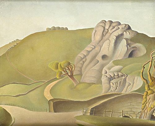
The depression at bottom left looks exactly like an old mine shaft, whereas the hole further back looks to be natural. It may just be a bit of artistic license, 'compiling' features not that far away - maybe he tried painting one of the swallets in its actual location and didn't like it, so he 'moved' it. Given there are no trees around it though, it seems unlikely to be a swallet, more of a collapse. Judging by his painting style, absolute realism wasn't his primary aim. It's very psychedelic in style - I'd like to see more of his work.

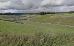
One of the old paintings we used in The Castleton Mines book showed a view of Peak Cavern Gorge from the village, relatively denuded of trees, and it shows a large opening 'somewhere' around the base of the slope that now holds the access path to Peveril Castle. Despite numerous long stares I've never been able to figure out where it could be - but then figured that the artist had probably just dragged one of the nearby Cave Dale caves 'around the corner' to make it fit, despite it breaking the rules of physics and optics - but you can do that in painting, unlike photography.
 

mikem

Well-known member
Page 2 includes painting of stalactites (& some unsuitable for children):
https://www.invaluable.com/catalog/searchLots.cfm?scp=m&ord=2&ad=DESC&alf=1&issc=1&shw=50&artistref=y3kouxy29g&row=1
 

Mrs Trellis

Well-known member
Fwiw I think it's looking nw towards Bradwell dale from roughly where the first credit crunch expedition camped on Nick Williams's land iirc.  The hill profile to the right is surely Hucklow edge/Abney Moor. Grindlow cavern is a possible (grid ref SK 1725 7713) . It's no longer in COPD but from memory it was a shaft in a field close to the lane leading from the B6049 to Great Hucklow & Grindlow.

Note the artist also painted Wardlow Mires.

The stals are surely Treak cliff cavern.
 

mikem

Well-known member
It is - page 301.

https://peakdistrictcaving.info/home/the-caves/wye/grindlow-cavern

It is also listed in "the history of the county of derby", 1829
 
Top