Potential at the bottom of the Neil Moss shaft

pwhole

Well-known member
Personally I think so - if Moss Chamber were only just discovered now I think it would be seen as even more exciting than it was then, not least owing to its alleged proximity to the line of Faucet Rake - if it still exists that far east. My plotting of that vein however suggests it trends further north, more toward Peak Cavern Gorge, and that Moss Chamber may be developed on another, less obvious vein altogether. But it's very difficult to work out the line of Faucet Rake, especially when several reputable books contradict each other on this issue. I'm not even sure if the Bottomless Pit is actually on Faucet Rake, as it's massively offset from the vein line at surface on the model, when all the passage development to the immediate west (Pilkingtons, Assault Course, Whirlpool) all reach the vein perfectly on the surface line.

The 'empty space' to the north of this area is enormous though, and may also contain the eastern extremity of Longcliffe Vein/Longcliffe End Vein - if it's not truncated by the Speedwell Vent. The Cave Dale Lava is also high overhead and just to the south, which is why the formations occur in Moss Chamber as it's just north of the 'umbrella' effect. But much water may have drained over the lip of this to the north, developing passages not yet found. Anniversary Aven must connect to something at the top, and I still believe a major excavation of Middle Bank Pot would be a worthwhile project. Interestingly the Upper Gallery follows the line of the 'Roger' cliff on surface exactly, as does the boundary of the lava.

The Neil Moss inscription seems to be in reef limestone, suggesting a very thick 'skin' of reef over the whole slope, at least at the altitude of the foot of the hill. I think that may prove to be quite important, as development of passage in the reef seems to be different to the main system and not necessarily governed by the regular Peak-Speedwell bedding and joint systems. The reef extends almost as far south as the Halfway House branch in the Speedwell canal, which is around 100m, so again, very thick there. Higher up the slopes it should thin out, but I think descending a shaft in Moss Chamber would still be in the reef. So yes, I think it would have been seen as a very good prospect, even now. But I wouldn't have gone down it without some enlargement!

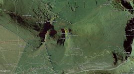
The red lines in the screengrab below are the veins, with the line of Faucet Rake (apparently) fizzling out at the base of Middle Bank Gully - all the veins on that slope seem to converge there, right on the edge of the volcanic agglomerate. I've extended the line of Longcliffe Vein back east toward Moss Chamber just to see where it ends up - Victoria Aven.
 

Attachments

  • Cowlow_Overall.jpg
    Cowlow_Overall.jpg
    217.4 KB · Views: 886

benshannon

Active member
The question is, will anyone ever go back down there? Or is it strictly forbidden as it's a grave?

I'm not advocating either way, I'm just curious on the ethics of it all
 

Mrs Trellis

Well-known member
Re your excellent graphic:- Son of Longcliffe, Tellyer's Venture, Nathalia's Anomaly. If you have info. which you can put on here please do. Pretty please.
 

pwhole

Well-known member
Hahah - I was waiting for someone to ask. Tellyer's Venture, as far as we can tell, is an old name for Longcliffe Engine, and until recently the name was a total mystery, though mentioned occasionally in old records. However, in an old Nellie Kirkham box extract I found the following scrap:

IX. S.E. H.10. (5). Ollerenshaw Senior.  Slop Moll definitely a mine drain, from Tellyer's Venture, and
also perhaps mines Slate Hollow, Vein on East side of latter runs across to Red Seats.
XVI. N.W. B7. setails of Fluorescent test.  (11)  (13).
"Ancient Castleton Caves"  Royse 1944. p.35 - 38.  (G.853).
"Peak's Hole"  Hedinger. 1820.  (G.1371).
Miscellaneous (49).  Ollerenshaw.W. hollow Tellyer's Venture (Tellyer [Tallyer], the nickname of one of
the Eyre's. Slate Hollow the East one.  (D.A.N. See G.1925.).

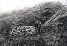
The Eyres appeared to have some sort of mine on Long Cliff, and it's possible they sold the title to the Bagshawes at a later date - though still very early. It also appears to be the shaft that the DPC opened under a massive beehive cap in 1909 (photo below - courtesy of and copyright the Derbyshire Pennine Club).

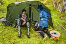
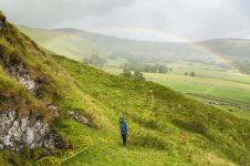
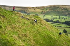
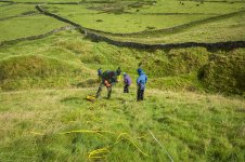
'Nathalia's Anomaly' refers to an interesting feature we found a couple of years ago. Mark Harwood of TerraDat wanted to do some sub-surface scanning of the Speedwell Vent, the large blob of volcanic agglomerate on Cowlow, and which appears to truncate all the veins heading SE after crossing Cowlow Nick, and so I helped him over a few days to do some basic scans in May 2017 - this is all documented in TSG 19. This work was later followed up by a second session of three days in September, headed up by Nathalia Da Costa Vieira of Cardiff Uni, who developed the project further as part of her MSc practical coursework and dissertation, and again, several of us from the TSG helped out. As part of the scanning session, we did a line down Middle Bank Gully, from just below Middle Bank Pot lip and down onto the large mound of the 'vent'. The scan showed a particularly interesting sub-surface feature, though the scan can't differentiate between 'empty space', water or clay/mud. However, it's not limestone or volcanic lava. The plot, and a few photos of the scan session are also below. Mark and Nathalia are under the umbrella with the expensive equipment in the pissing rain.

One other point is that the TSG had an active dig here in the early/mid 70s, and I recently acquired a faded print in an old album of a washing-line heading up the valley from a shaft they were digging out - unsuccessfully it turned out as it didn't go very far. But the 'anomaly' was lower down the slope from that, closer to the umbrella area. So who knows - it's certainly interesting. But it is Duchy land and apparently that may be why the original dig was curtailed rather hurriedly, as they didn't have permission.

The scan plot is copyright Nathalia Da Costa Vieira/Cardiff Uni, and the photos are mine. This is getting a bit off-topic from Neil Moss though, so maybe it should be split to somewhere else, mods? I think there's even a Middle Bank Pot thread somewhere;)
 

Attachments

  • 1920's pre prob  Taylors Venture Castelton M Burnby  WM Sissons prob by Winder_sm.jpg
    1920's pre prob Taylors Venture Castelton M Burnby WM Sissons prob by Winder_sm.jpg
    292 KB · Views: 304
  • MiddleBank_plot.jpg
    MiddleBank_plot.jpg
    215.1 KB · Views: 262
  • _IGP5513_sm.jpg
    _IGP5513_sm.jpg
    218.7 KB · Views: 229
  • _IGP5510_sm.jpg
    _IGP5510_sm.jpg
    278 KB · Views: 200
  • _IGP5514-5515_sm.jpg
    _IGP5514-5515_sm.jpg
    166.9 KB · Views: 190

AR

Well-known member
aardgoose said:
AR if you have the full references for those articles I'll add them to the registry entry

Here you go:

Wolstenholme, P. (2017). ?Son of Longcliffe - An Unexpected and Dramatic Diversion? The Journal of the Technical Speleological Society vol. 19 pp 169-178
Wolstenholme, P. (2019) ?Longcliffe Mine, Castleton? Mining History vol. 20 no. 5 pp 1-18
 

Brains

Well-known member
Wonder how much taller than his contempories "Tall Eyres" really was, and would he still be considered tall today?
Any relation to that Yorkshire ferret Jim?
 

mikem

Well-known member
There's a good chance, as the Eyres were centred around Derbyshire & have plenty of links to lead mines (inc. Eyre's Grove):
https://chstrial.files.wordpress.com/2016/10/mastercastleton_hopemedievalcommonpeoplehistoricalreport-141113.pdf
Even Richard Torre, in 1654 admits to neglecting to free eight meers in Odin [Mine] and in consequence lost four of them to Eyre and partners (Rieuwerts 2007, p31).
 

Mrs Trellis

Well-known member
Charlotte Bronte got the name for her Jane Eyre from the Hope Valley when she stayed at Hathersage.

The miner's family name Iggo intrigues me. Sam may know some of his contemporaries still having this name.
 

Brains

Well-known member
Mrs Trellis said:
Charlotte Bronte got the name for her Jane Eyre from the Hope Valley when she stayed at Hathersage.

The miner's family name Iggo intrigues me. Sam may know some of his contemporaries still having this name.

Sounds like a corruption of Ignatius to me...
Guess Jim Eyre had no option BUT to be an underground explorer given the family traditions...
 

pwhole

Well-known member
Mods - this thread really is diverging severely from its original topic. And here's some more:


[gmod]Yes, the thread was diverging and has been split to a new topic. :) [/gmod]

The Eyres sold 'Eyre's Grove' to the Speedwell partnership in the 1780s, despite it being only one meer in length. In depth terms it was a great deal though, as it contained all of Leviathan and the associated workings, and obviously clear access to their boardwalk directly below at the Boulder Piles. The Eyres still run the farm shop at Brough, if it is the same bunch? 134 years there and still going. I wondered if maybe the old nickname was maybe indicating a fondness for accounting?

Richard Torre definitely had interests somewhere at Longcliffe in 1672, and the Eyres were always involved in the early Castleton deals, though by 1708 Bagshawes had the main title - and given Odin and Longcliffe were worked more or less simultaneously by the same partnership in the early 1700s, with all the legal shenanigans that would have involved, I'm sure the Eyres would have been in there somewhere, even if just selling shares.

Tellyer's Venture is also briefly mentioned in an old book: BROOKSBANK, JH. 1920. Castleton: its traditions, sayings, place names etc. Transactions of the Hunter Archaeological Society, Vol 3, pp 34-52.
One - old road - passing down the cleft called Crumm-le-dale, and close to Tellyers Venture (the old entrance to the mine afterwards called the Speedwell) was used regularly by the lead miners on their journeys to and from work

The shaft was dropped by the DPC in 1909 after they dismantled the beehive cap, and I suspect that most of the deads that still litter the slope and the floor of Cowlow Nick are from that. It led into a large chamber blocked with rubble at the bottom, but they quoted the shaft and chamber having a combined depth of 180 feet (55m). Given its lower position on the hill, that would lead it to roughly the altitude of the Speedwell Streamway, though obviously nowhere near it - but far closer to what we're looking at.

The thing that baffles me about this shaft is who covered or backfilled it again afterwards? I'm not sure exactly when the NT took over the ownership of this parcel, or who from, but I'm guessing it was filled in before that. It has a very solid retaining wall on the dale flank and a small hole in that shows the shaft top to be totally backfilled 'at the top'. But for 55m? Can you imagine how much rubble would have had to be hauled up the hill to then backfill a 2m-diameter shaft for 55m depth? We just hauled out less than half that, and it's a considerable volume when restored to the surface. I suspect it's not backfilled that far - nor many of the others around there.

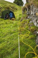
The photos below show another scan line being sent down the flank of Cowlow Nick, after being directed over the known passage in Son of Longcliffe at the top end as a 'control' - it crossed the Tellyers Venture shaft top before crossing all the other workings in the floor of the dale and then re-entering the lava lower down. The results weren't entirely conclusive, despite being done at high resolution (1m gaps in the cable) - though this does reduce the depth scanned considerably.
 

Attachments

  • _IGP5517_sm.jpg
    _IGP5517_sm.jpg
    236 KB · Views: 160
  • _IGP5523_sm.jpg
    _IGP5523_sm.jpg
    256.9 KB · Views: 172

mikem

Well-known member
Mrs Trellis said:
The miner's family name Iggo intrigues me. Sam may know some of his contemporaries still having this name.
Moved up from London: https://www.surnamedb.com/Surname/Iggo
 

Chocolate fireguard

Active member
Free Births, Marriages & Deaths (Free BMD) is a useful resource.
A search for the surname Iggo produced several hundred events between the years 1837 & 1992, virtually all of which seemed to be evenly split between the Newcastle area and what is now S Yorkshire.
 
Top