New to surveying, advice sought.

Pete K

Well-known member
Hi all. I have been doing a bit of a practice survey in a local project, having done nothing before and being entirely self taught.
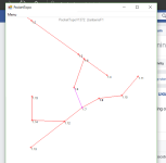
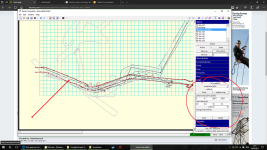
I used a Bosch PLR50 and a standard Silva compass to make a plan of one level of a fairly simple mine. I took the readings down on paper and returned home. I then inputted them into PocketTopo and had a look at the centreline survey and all is well apart from one issue, it is a complete mirror image to real life. It is like the mine is being viewed from underneath, not as a top down.
I thought I may have read the wrong needle like an idiot all night but the survey does not work if I change all the bearings by 180. If the screenshot appears here, the survey would be correct if it were mirrored along the axis of the main level (long straight section).

Is this some crazy setting in PT or have I done something totally bizarre? Off out tomorrow to redo the bearings but thought it was worth asking here in case I return with the same results.
Again, total new-bee to this and self taught so small words only please! Any ideas what I'm doing wrong?
 

Attachments

  • 2017-04-24.png
    2017-04-24.png
    38.8 KB · Views: 341

Pete K

Well-known member
Figured it out in a proper eureka moment at 6am this morning. Human error reading the bearings and having a non sighted compass. I clocked the entry passage was not the correct angle when I compared it to the surface map and worked back from there.
Stay tuned for more blunders and pleas for help no doubt!
 

Pete K

Well-known member
Okay, here's helping for some help again.
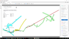
I have completed the survey of the mine now. We made 2 trips, the top level surveyed on one trip and the remaining 5 floor surveyed on the second. I'm struggling with Therion and how to compile the map. I have a survey for the top floor already and have begun drawing up the rest in a separate file. My brain has fried itself trying to work out how to create a map with multiple levels. I want to draw each floor separately and then compile them into one, is this possible or does it all need drawing up together?
I know there is a map / endmap block that I can use to compile the different maps but I can't seem to get the code right. Would anyone have an example block with 2 or 3 different map sections I could see to work out where I'm going wrong? This is not a natural skill of mine so any help is appreciated.
For clarity, I'm not talking about combining scraps in one plan, I mean combining multiple plans as a PDF final survey.
Cheers
 

Attachments

  • 2017-05-16 (1).png
    2017-05-16 (1).png
    31.9 KB · Views: 215
  • 2017-05-16.png
    2017-05-16.png
    27.4 KB · Views: 210

Swallowneck

Member
Pete, getting your head around how to build maps in Therion is a little tricky.
if I understand your request correctly you have made surveys of different mine levels and now you want to output a pdf plan with all those 6 surveys showing. Without seeing your data I can't tell what you are doing wrong but I can say if your 6 surveys are not tied together somehow then Therion will not be able to place them correctly in relation to each other on your final map.
You could do this by starting say level survey 2 at the last station in level 1 survey or by starting all surveys at a common point like a station at the entrance. If that is not possible because of multiple entrances the find a good point on the surface and do a surface survey to each entrance or to the first station in each of your levels.

Map output is relatively easy and you should do something like this with your final plan .th file.

input Level1.th
input Level2.th
input Level3.th
and so on.

map MineLevelsPlan    -title "MineLevelsPlan"

Level1Plan
Level2Plan
break
Level3Plan
Level4Plan
Level5Plan
Level6 Plan

end map


join Level1SP3  Level2SP1

equate 1.6@Level1  1.1@Level2


The break command puts Level 2 above Level 3 so that any part of Level 3 under Level 2 will be a lighter grey to indicate it is underneath.
You will probably need to use two more commands, join and equate. Join basically joins two scraps in two different surveys and equate joins two survey stations in two different surveys. These commands enable Therion to compile a final plan using your 6 separate surveys.  I suspect now you are going into meltdown I know I did at this stage.

To be honest I think you may be trying to run before you can walk, you need to grasp the basics first or you will struggle then you will do what many have done before which is give up because you decide Therion is too hard. The best thing to do is get on one of the training courses run by the Cave Surveying Group or at the very least follow Footlegs excellent Therion tutorial which can be found on the Therion Wiki page. There is loads of useful info on Therion if you know where to look.

http://wscc.darkgem.com/footleg/therion/Therion%20Tutorial%2015thMar2016.pdf

The next thing that really helps is having someone to bounce things off, a mentor if you like this will save you hours and hours of dicking about. if you would like some help PM me and lets try and get you going. What you are trying to do should only take a short while once all your ducks are in a row.

Nick


Pete K

Well-known member
Thanks Nick. Funnily enough the join and equate command came into my head about 3am this morning as these things generally do. That looks like the answer I'm missing but I'll certainly shout if I need any more help. The tutorial is excellent and I've had it open in the browser pretty constantly but it is so much info to take on board.
Cheers for the help here and to the PM I also received from another member.
 

Pete K

Well-known member
Okay, next question. Map vs Atlas.
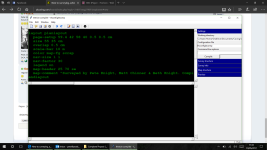
I really want a simple printable PDF of either A4/A3 size for this survey. When I compile a map I get the error "Map is too large for PDF format. Try a smaller Scale!".
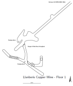
I don't understand this as when I switch to atlas, it compiles fine and also produces a PDF file. Alright, the individual pages are smaller but if anything the atlas document must be larger than a map.
I don't really want an atlas because it splits the survey when there is no need, it's a small mine. See below for a screenshot of the atlas for an idea of size.

I have tried playing about with the scale and base-scale arguments but it won't work until I get to about 1 15000 and then suddenly jumps to microscopic scale, nothing in between produces a map. I could play with the other output formats but PDF is what I and everyone else can access and print with ease so would rather not.
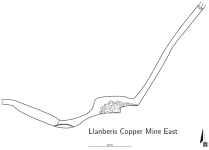
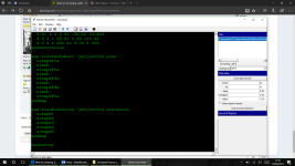
I was wondering if it is an issue with the scaling used at the front end of the survey production, where you set the scale in the draw window (see second picture)?

Help is once again very appreciated.
 

Attachments

  • 2017-05-19.png
    2017-05-19.png
    179 KB · Views: 187
  • 2017-05-19 (1).png
    2017-05-19 (1).png
    177.6 KB · Views: 194

Pete K

Well-known member
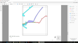
Sorted! Has taken all day but I had to play about with the page sizes layout code and eventually got it to A2. Scales nicely to A4 print size.
 

Attachments

  • 2017-05-19 (2).png
    2017-05-19 (2).png
    283.2 KB · Views: 193

Pete K

Well-known member
I bet there are far more elegant ways to do it but I re-jigged the page size in the -layout section in the theconfig and broke the small floors up into individual scraps on the map, allowing me to use the 'color map-fg scrap' block for the differently coloured layers.

There are some excellent resources out there for Therion but a lot is written for a reader with a higher level of knowledge on the subject already. The Wiki is very useful. I read that thread you posted but the scale stuff did not work for me, it was the actual page size I needed to increase.
 

Attachments

  • 2017-05-19 (3).png
    2017-05-19 (3).png
    232.8 KB · Views: 173
  • 2017-05-19 (4).png
    2017-05-19 (4).png
    196.9 KB · Views: 179
Top