source testrocks.th2
export map -layout local -o testrocks.pdf
#input blocks_AUT
#input blocks_SKBB
layout local
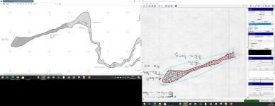
scale 1 100
symbol-set NZSS
symbol-hide group cave-centreline
#copy blocksAUT
#copy blocksSKBB
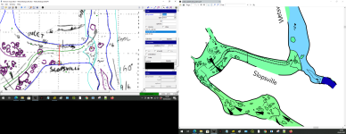
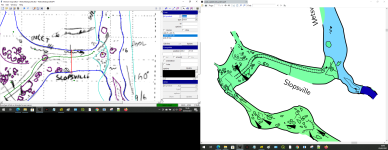
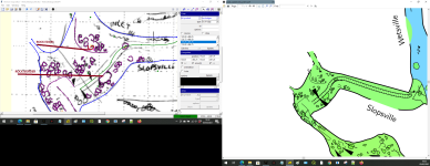
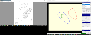
symbol-assign area debris TEST
symbol-assign area blocks TEST
#symbol-assign area blocks AUT
#symbol-assign area blocks SKBB
code metapost
initsymbol ("a_debris_TEST");
initsymbol ("a_blocks_TEST");
def a_blocks_TEST (expr p) = T:=identity; symbol_distance:=1; scale_factor:= 0.8; pickup PenC; path q, qq; q = bbox p; pair outside; outside:= ulcorner q + up; picture tmp_pic; uu := max(u, (xpart urcorner q - xpart llcorner q)/100, (ypart urcorner q - ypart llcorner q)/100); tmp_pic := image( for i = xpart llcorner q step symbol_distance*uu until xpart urcorner q: for j = ypart llcorner q step symbol_distance*uu until ypart urcorner q: qq := punked (((-.5uu,-.5uu)--(.5uu,-.5uu)--(1.05uu,0.05uu)--(.5uu,.5uu)--(-.5uu,.5uu)--cycle) randomized (uu/2)) scaled (uniformdeviate(0.7)+scale_factor ) rotated uniformdeviate(360) shifted ((i,j) randomized 0.75uu); if xpart (p intersectiontimes qq) < 0: if pointinside((i,j),p,outside): thclean qq; thdraw qq; fi; else: qq:= qq scaled (uniformdeviate(.2)+.5 ) if xpart (p intersectiontimes qq) < 0: if pointinside((i,j),p,outside): thclean qq; thdraw qq; fi; fi; fi; endfor; endfor; ); clip tmp_pic to p; drawoptions(); draw tmp_pic; enddef;
def a_debris_TEST (expr p) = T:=identity; pickup PenC; path q, qq; q = bbox p; picture tmp_pic; tmp_pic := image( for i = xpart llcorner q step u until xpart urcorner q: for j = ypart llcorner q step u until ypart urcorner q: qq := punked (((-.2u,-.2u)--(.2u,-.2u)--(.2u,.2u)--(-.2u,.2u)--cycle) randomized (u/2)) rotated uniformdeviate(360) shifted ((i,j) randomized u); if xpart (p intersectiontimes qq) < 0: thclean qq; thdraw qq; fi; endfor; endfor; ); clip tmp_pic to p; draw tmp_pic; enddef;
endcode
endlayout


")