DistoX2 an alternative

Subpopulus Hibernia

Active member
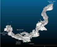
You can read more on the Caveatron here - http://caveatron.com/index.html

It's quite a sophisticated device, it does the usual compass, inclination, and length measurements, but it's primarily a handheld 3D scanning tool.

I'm not sure how well it would replace or succeed the DistoX -  it looks quite techy to assemble and set up and is about 3 times the size of the DistoX. The beauty of the DistoX was that it is a relatively simple tool, that can be fairly easily produced  and assembled - which is why there's so many of them. In terms of producing devices, most of the other cave surveying tools I've seen are of fairly limited scalability and won't reach the level of ubiquity that the DistoX had.
 

Benfool

Member
I was looking at the Caveatron last night, looks pretty cool, but a little over engineered and not something that anybody could put together.

The other issue is that it uses a discontinued disto at its primary distance measurer - I couldn't find a single one on ebay. This is certainly not ideal so I cant see it being a long term replacement for the Distox.

Hopefully something will come along that has the scalability the Distox did :(.

B
 

Bob Mehew

Well-known member
I noted that the Caveatron spec for its compass was 'below +/- 1.5' degrees which might just miss the BCRA Grade 5 requirement of below +/- 1.0.  What was the DistoX spec?  Pity about using potentially unavailable parts.
 

Subpopulus Hibernia

Active member
Bob Mehew said:
I noted that the Caveatron spec for its compass was 'below +/- 1.5' degrees which might just miss the BCRA Grade 5 requirement of below +/- 1.0.  What was the DistoX spec?  Pity about using potentially unavailable parts.

Properly calibrated, the DistoX should be below 0.5 degree accuracy.
 

Dave254

New member
The recommended range finder for the Caveatron is discontinued, however there are 2 suitable replacement parts that are listed in the documentation.  The only reason for the recommendation of the discontinued range finder is that the measurement time was limited to 1 second which benefited the accuracy of the lidar survey (the other range finders have a variable measurement time of upto 3 seconds).  For normal cave surveying it makes no difference whether the preferred range finder is used or not (it might just take upto 3 seconds to take a measurement instead of 1).

The data specified on the website with regards to compass accuracy is out of date and refers to the first version (there was a 2nd updated version released a few month ago).  This includes and updated/improved IMU which will improve the compass accuracy (I don't know what the accuracy is in the 2nd version off the top of my head).

I have got one, however I did not manage to test it properly before lock down began.  If I can work the forum properly then there should be a quick unedited lidar scan of the entrance to Great Douk below!
 

Attachments

  • Picture2.png
    Picture2.png
    129.4 KB · Views: 299

Dave254

New member
I built it, it isn't too hard if you are a bit technically minded.  The 2nd version had a 3d printed case, so unless you have access to a 3d printer you would need to fabricate a case for it.  There is a list of the bill of parts and construction guide that Joe has put together that can be found here https://github.com/Caveatron/caveatron/tree/master/documentation In terms of cost, the most expensive part is the Lidar scanner at around ?65, if you just wanted to use it as a normal cave surveying tool then this would not been needed.  Other than that, around ?30 for the main control board, ?25 for the range finder and then rest of the parts are between ?5-?10.
 

Subpopulus Hibernia

Active member
Yeah, that looks way beyond my technical capabilities to produce.

Out of interest, what do you intend to use it for? Traditional station to station surveying or do you have a particular requirement for 3D scans?
 

maxf

New member
Dave254 said:
I built it, it isn't too hard if you are a bit technically minded.  The 2nd version had a 3d printed case, so unless you have access to a 3d printer you would need to fabricate a case for it.  There is a list of the bill of parts and construction guide that Joe has put together that can be found here https://github.com/Caveatron/caveatron/tree/master/documentation In terms of cost, the most expensive part is the Lidar scanner at around ?65, if you just wanted to use it as a normal cave surveying tool then this would not been needed.  Other than that, around ?30 for the main control board, ?25 for the range finder and then rest of the parts are between ?5-?10.

Do you have any data examples you can share that you have collected with it ?
 

Badlad

Administrator
Staff member
[admin]Hi all. I've split the topic away from 'DistoX where can I get one' as requested. Have renamed the new topic. Hope you're all ok with that. Cheers[/admin]
 
for a 3d printed case PLA wont last too long (its not properly waterproof) but event without a printer you can get a laser sintered version from shapeways just upload the STL files. There are loads of other places that the 3d printed parts can be ordered from
 

pwhole

Well-known member
This looks really interesting, especially for the less wet/gnarly sites where moving about is relatively easy. The ability to output a 3D model as standard could be very useful, not least as that can then also be 3D printed. I'm sure the case design/construction can be streamlined and improved, but the cost alone is a reason to at least consider one, especially for clubs and groups who may not have a dedicated surveying team onboard but have access to interesting sites. The fact that a high-quality survey could potentially be done on the date of discovery by anyone with only basic skills is a huge step forward really.

One day we'll all have a small one on our helmets ;)
 

Alex

Well-known member
Is it available to buy? I can really do with a surveying tool myself, but I have no electronic skills to make my own.
 

Subpopulus Hibernia

Active member
pwhole said:
This looks really interesting, especially for the less wet/gnarly sites where moving about is relatively easy. The ability to output a 3D model as standard could be very useful, not least as that can then also be 3D printed. I'm sure the case design/construction can be streamlined and improved, but the cost alone is a reason to at least consider one, especially for clubs and groups who may not have a dedicated surveying team onboard but have access to interesting sites. The fact that a high-quality survey could potentially be done on the date of discovery by anyone with only basic skills is a huge step forward really.

One day we'll all have a small one on our helmets ;)

I'm not buying into the idea that anyone with 'anyone with only basic skills' could produce a high-quality survey on the date of discovery with this device. It looks like it would still require a fair degree of specialist skill to properly operate the device, and manage the data, and output it in some useful format. As it stands, with the advent of smartphones and DistoX, surveying is more accessible than ever, and yet it's still very much a niche activity. 

It's also worth distinguishing between a 3D model and a drawn 2D map - the latter of which is still dependent on someone sitting down for a long time and producing a drawing with the data captured from the cave. Right now I'm not sure how effective 3D scanning is as a means of producing a 2D survey.

Basically I remain to be sold on the value of 3D-scanning as a cave surveying technique. I can see that having a 3D model of certain passages or caves would have specific uses, but it is in the end just another means of data capture and it isn't going to automate the process of surveying, as I've seen some people suggesting.

 
look at open street map to see how this is all a game changer. This kit will revolutionise the speed that surveys are produced. For the time being it will still need skilled people to join the data together but that will, in time, also be automated. Its also going to have a similar effect on route finding too :)
 
Meanwhile, in the USA, DARPA have a Subterranean Challenge for fully automated surveying - including Natural cave networks:

https://www.subtchallenge.com/index.html#subdomains (may be slow to load).

There are some impressive results from mines on there...
 

Dave254

New member
mountainpenguin said:
for a 3d printed case PLA wont last too long (its not properly waterproof) but event without a printer you can get a laser sintered version from shapeways just upload the STL files. There are loads of other places that the 3d printed parts can be ordered from

The case is printed in PTEG which is a lot more durable than PLA, it can also be given an epoxy coating which will improve the water resistance. I also remember reading somewhere that PLA will start to break down after prolonged water exposure.The scanner is designed by a guy in Texas and is probably not best suited to our caves in terms of durability. In the future I might look towards modifying an IP67 water plastic enclosure for my one, this would also hold up better to bumps and scratches.
 

Dave254

New member
Do you have any data examples you can share that you have collected with it ?

Unfortunately not yet, I have literally taken it out for a 2 hour test run the evening before lock down started and so I have only produced the quick test which I have put on this thread.

The actual data output consists of 2 files, a survey file and a point cloud file. The survey file which is in a format for walls (its American!) contains the normal survey data (survey stations, distances, azimuth, inclination etc) this file layout could be altered for a European survey program if required. The second is just the point cloud data file. The survey file allows you to check the survey file and adjust any loop closures prior to adding the point cloud. The point cloud is then put into a point cloud program (I have used cloud compare because it is free!) this will then produce the 3D map. I haven?t yet found the best method for sharing these point clouds due to the file size (the example I have attached above is only a small section of passage and consists of 1.6million data points)
 

Bob Mehew

Well-known member
Subpopulus Hibernia said:
I'm not buying into the idea that anyone with 'anyone with only basic skills' could produce a high-quality survey on the date of discovery with this device.
Regarding ability, I accept that it will take someone adept at electronics to make the circuitry.  3D printing is a different skill set but one can either bodge a container to fit or else buy the cases printed as has been mentioned. 

My limited experience of a DistoX suggests that some one should be able to learn how to calibrate the device, if need be by seeking advice from the Caveatron forum.  Using a DistoX is not demanding so I would expect similar for this device. 

I accept the software might be a bit of a challenge to a person with limited computer skills.  But to be derogatory, most processes require a level of skill so inevitably some will not be able to use it.     

Where I would accept there is a skill is transforming a set of x, y and z data into a survey and no doubt transforming a 3D scan into something as presentable as Dave 254 has produced.  Drawing up a survey is a skill which no doubt many could develop but it is likely only a few will have the skill based on alternative activities (such as a building surveyor or architect).  But in my judgement, just getting the data is the most significant step and most cavers should be capable of achieving that task.

The other thing to bear in mind is that whilst most free 3D scan presentations just show the external 'skin', I have no doubts that software is coming along which will enable you to get inside that skin to give you a visual impression of the cave. 
 
Top