Hall2501
Member
Modelling cave flood events in Yorkshishire
*disclaimer* This idea is just for fun/interest, I don't recommend using any outcome of this project to decide whether it's safe to go caving.
I've recently been wondering whether it would be possible to create some kind of empirical model relating recent rainfall/surface river levels to the water levels in caves and the period of time required for caves to drain to safe water levels after periods of heavy rain. This could allow one work out which caves are safe to go in without relying solely on judgements from people with a good feel for how the cave responds to water. Obviously common sense and judgment from those experienced with the caves should definitely take priority when deciding if a trip should be given the green light as well as forcast weather and other factors but it would at least be interesting to see how well these models match up with how people think the cave stream levels behave during/after heavy rain.
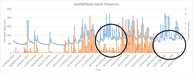
My idea is to make some devices capable of long term data logging of water levels and place them at points throughout a cave that are prone to flooding/dangerously high water levels after heavy rain (e.g. eureka junction, Easegill or Kingsdale master cave). The device I have in mind would use a type of pressure-based water depth sensor from remote control submersible devices with 0.16mm precision and +/- 4cm accuracy. The device should be able to take a water level reading every 5-10 minutes for several months before the batteries need changing. I would also place a rain gauge above the cave and use data from the UK's Environment Agency flood-monitoring network (local rain gauges/river level monitors) to monitor rainfall/surface water levels. Then use the data I've obtained to create a model of cave flooding events, where you can predict how flooded a cave is or how long it will take to drain based on factors which can be observed without going to the cave to check. It might also be interesting to log surface above cave river water temperatures and cave water temperatures as a proxy for working out whether water can come in direct from surface streams (you would expect this to be colder) or perculation (you would expect this to be warmer, as it's had longer to equilibrate to the constant cave temperature).
This is currently just an idea but lets see how it goes, I'll post any progress updates here. So far I've designed an insitu long term cave water level monitoring device (?120), obtained a surface tipping bucket rain gauge and temperature logging devices.
*disclaimer* This idea is just for fun/interest, I don't recommend using any outcome of this project to decide whether it's safe to go caving.
I've recently been wondering whether it would be possible to create some kind of empirical model relating recent rainfall/surface river levels to the water levels in caves and the period of time required for caves to drain to safe water levels after periods of heavy rain. This could allow one work out which caves are safe to go in without relying solely on judgements from people with a good feel for how the cave responds to water. Obviously common sense and judgment from those experienced with the caves should definitely take priority when deciding if a trip should be given the green light as well as forcast weather and other factors but it would at least be interesting to see how well these models match up with how people think the cave stream levels behave during/after heavy rain.
My idea is to make some devices capable of long term data logging of water levels and place them at points throughout a cave that are prone to flooding/dangerously high water levels after heavy rain (e.g. eureka junction, Easegill or Kingsdale master cave). The device I have in mind would use a type of pressure-based water depth sensor from remote control submersible devices with 0.16mm precision and +/- 4cm accuracy. The device should be able to take a water level reading every 5-10 minutes for several months before the batteries need changing. I would also place a rain gauge above the cave and use data from the UK's Environment Agency flood-monitoring network (local rain gauges/river level monitors) to monitor rainfall/surface water levels. Then use the data I've obtained to create a model of cave flooding events, where you can predict how flooded a cave is or how long it will take to drain based on factors which can be observed without going to the cave to check. It might also be interesting to log surface above cave river water temperatures and cave water temperatures as a proxy for working out whether water can come in direct from surface streams (you would expect this to be colder) or perculation (you would expect this to be warmer, as it's had longer to equilibrate to the constant cave temperature).
This is currently just an idea but lets see how it goes, I'll post any progress updates here. So far I've designed an insitu long term cave water level monitoring device (?120), obtained a surface tipping bucket rain gauge and temperature logging devices.