Izvor Licanke Survey Feeedback

Tseralo

Active member
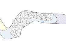
This is my first time drawing up a survey from scratch. We have lots of different kinds of data most of it historic but the main drag of the first chamber was resurveyed by Mark Burkey, Fred Nunn and myself this trip. If anyone more experienced has any feedback on making it more readable or things you would like to see on a survey I haven't done let me know.

I would like to add the dive line once I've found a good way to do that in therion. An elevation is also on my list.
 

Attachments

  • IzvorLicankeMasterplan.png
    1 MB · Views: 745
  • IzvorLicankeMasterplan.pdf
    184.9 KB · Views: 175

aricooperdavis

Moderator
I have no experience whatsoever at creating surveys, but as a survey user I find the direction of water flow here a bit mystifying. Very smart looking survey though!


Attachments

  • Screenshot 2021-09-03 142550.png
    Screenshot 2021-09-03 142550.png
    126.5 KB · Views: 160

Tseralo

Active member
aricooperdavis said:
I have no experience whatsoever at creating surveys, but as a survey user I find the direction of water flow here a bit mystifying. Very smart looking survey though!

Good spot, that's just me double-clicking when adding a point.

Benfool said:
What about the 2019 limit?

B

Good shout I must have missed that il add it. Obviously, there was no 2020 limit.
 

Ian Ball

Well-known member
Hello, this is brilliant! top effort.

I'm not a fan of a multi point compass, I prefer just north to be indicated as the rest are not difficult to work out and the N stands out more. The Out of Depth lake and Boulder Choke are on the plan, should they be off to the side?
Is Out of Depth Lake a name? it looks the same as the descriptions like Climb (+4 I assume) or Boulder Choke?

I look forward to the Cross section estimations to follow? 

As a matter of curiosity, are sump 3 and 4 always separate or would they join in high water?

Again in the shape of embarrassing myself as I do not know the person, but is Rita Cookson Mallinson, Rita Mallinson Cookson?


Steve Clark

Well-known member
Looks great, brilliant effort!

I've had a long learning curve with therion over many years drawing up the surveys for St Georges, Montvalent. It took a while to figure out the best way to use it for a diving dominated cave. We've needed bits of metapost code for various things. I've had quite a bit of help from Torsten doing a similar thing with their survey at Cabouy. We've been swapping ideas on various things.

Our survey is here : https://www.dropbox.com/s/watp4mkphcsd1zj/St_Georges_1-1000_v1.4.pdf?dl=0

(Actually download it, the dropbox viewer is awful)

Would be really happy to help out with anything you want to figure out how to do, dive-line etc. No problem sending you our bits of code.

Anyway, my bits of feedback from a diver's perspective (I'm very much a newbie 'dry' caver) :

p.xxx m labels from dive base would be a good reference for overall scale & planning.
more contrast between sump/lake (air space above) would make it clearer.
legend says max depth 60m, but it's not obvious where this is(?) I assume this is a therion generated depth below entrance and not a mfw water depth? (Will become more obvious with the elevation)
the compass rose 'N' is really small and hard to see
the 'floor step' at the end of sump 2 - do you have a depth for the edge? would be handy to know whether you are deco in the shaft/rift(?) or in the surfacing tunnel bit. (From experience, these are some of the hardest bits to draw, lots going on in 3D)

Steve


Tseralo

Active member
Thanks, Steve and Ian some good points particularly re contrast and distance/depth labels. That St Georges survey is excellent if your happy to share the metapost for the dive line that would be most helpful. How are you doing the lines for the labels as well? Have a missed an option in therion?

I ought to do a writeup or something for diving surveys once this is done as your right there are a bunch of gotchas as very few examples, Anton van Rosmalen from the Coudouliere project has also been offering me some advice so there are a few of us using therion this way it seems. My next project is one I can opensource so perhaps that will help.
 

Steve Clark

Well-known member
For the dive line, I created a custom line type. You need to add this code within your layout...endlayout section :

code metapost

def l_u_caveline (expr P) =
T:=identity;
pickup PenB;
thdraw P withcolor (1, 0.5, 0);
enddef;
initsymbol("l_u_caveline");

endcode


This creates a user defined line type called 'caveline'. It is coloured orange (1.0 red, 0.5 green, 0.0 blue). You can obviously change this if you want a different colour.

To use it in the th2 scrap editor, select line and add u:caveline to the type box. You can then draw the line between the stations or wherever it goes for T's etc. You can either manually adjust it to make it align at scrap junctions, or just stop at a common station and it should align automatically.


Steve Clark

Well-known member
For the p.xxx m labels and other similar notes, I used point label within the scrap editor/th2 file, as I'm sure you already have.

For the little marker arrows/lines, I used a standard straight line with type 'section'. This line type can cross walls without any issue. It must be straight, if you make it curved it will behave like the section markers (see therion book for how these work, it's a bit of a fudge)

It can be difficult to align the end of the section line with the label. You can specify the alignment within the 'Options' box of the line dialog on the right of the editor.

e.g.

-align bl -text "<right>T. p.373m
(Line to buoy in Salle de Lavaur)"

This aligns the text to the bottom-left (bl) of the actual point. The <right> will right align the paragraph text, the
will add a line break.
 

Steve Clark

Well-known member
The code for the alternative north arrow is below. Again, it goes in the layout...endlayout. You can put multiple def...enddef within a single code metapost.....endcode

code metapost

  def s_northarrow (expr rot) =
    begingroup
      interim defaultscale:=0.7; % scale your north arrow here
      T:=identity scaled defaultscale rotated -rot;
      interim linecap:=squared;
        interim linejoin:=rounded;
      thfill (-.5cm,-.1cm)--(0,2.5cm)--(.5cm,-.1cm)--cycle;
      pickup pencircle scaled (0.08cm * defaultscale);
      thdraw (0,0)--(0,-2.5cm);
      pickup pencircle scaled (0.16cm * defaultscale);
      p:=(0.4cm,0.6cm);
      thdraw ((p--(p yscaled -1)--(p xscaled -1)--(p scaled -1)) shifted (0,-1.0cm));
      label.rt(thTEX("mg") scaled 1.6, (.6cm,-1.6cm)) transformed T;
    endgroup;
  enddef;

endcode
 

Steve Clark

Well-known member
Another useful example is Torsten's survey. Link here :

https://www.thehiddenriverproject.org/downloads/Reseau_de_lOuysse.pdf

They have more 'dry' passage and have changed the background colour to grey so the dry sections appear obviously white. This helps when the passages get more complex. It's clearer when viewed on a PC screen or projector. No good for printing obviously.
 
Top