Jingling pot, no not that one

Samouse1

Active member
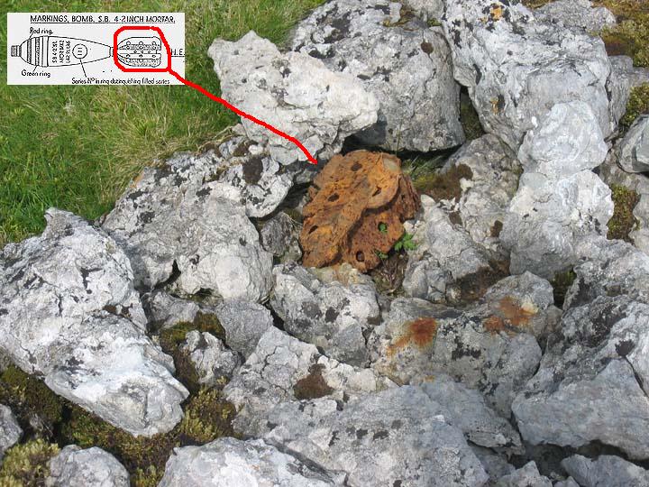
I was checking out a map of the lakes, and spotted Jingling pot on the map, south of Shap on Hardendale fell. The satellite shows a very inviting shake hole and I was wondering if there was any more information on it, northern caves and CNCC were dead ends, mostly due to Jingling being a popular name for caves apparently. Has anyone been, or know anything else about it?
 

Pitlamp

Well-known member
Not been there but have done a fair bit of stomping around the Cumbrian Ring of limestone around the Lake District. (Not looked - but there may be something about this in Phil Murphy's BCRA publication on the Cumbrian Ring?)

If you want it checking (if it's a long way for you to travel) I can always ask "Our man in Shap" to take a glance when he's out for a stroll and report back? PM me if you think this wiould be useful.
 

Samouse1

Active member
Was going to be over that way anyway, so will have a nosey if I get an hour spare, just wondered if anyone knew anything. I will report back after New Years if it?s interesting
 

Pitlamp

Well-known member
Ah grand; you can sort it directly.

Bet yes please; it'd be good to read about your findings.  (y)
 

mikem

Well-known member
Ere tis: https://northerncaves.co.uk/caves/details.php?id=1988

Whilst none are on CNCC, below are all in the latest Northern caves (jingling is 9m deep on p.403; dukerdale pots go up to 4; there are also kitchen gill valley pot, equinox hole, blue John holes & rising in area):
The region known as Dukerdale Pots at the head of Dukerdale valley is made up of a cluster of potholes, shake holes and caves. The following are the more notable:
Dukerdale Pot 1
Dukerdale Pot 2
Dukerdale Cave
A little further south are:
Tailbrigg Pot 1
Tailbrigg Pot 2
Tailbrigg Pot 8
Hollow Mill Pot
Jingling Pot
Fells End Pot
https://www.coasttocoast.uk/yorkshire-dales/kirkby-stephen-keld/dukerdale/

Hugh's cave (Alistair's link) is near haweswater
 

Beardy

Member
Whilst none are on CNCC, below are all in the latest Northern caves

not so  - the original poster is looking at a lump of limestone on the other (W) side of the M6 some distance to the West

Regards
Beardy
 

mikem

Well-known member
Actually, just realised that's not the same, but came up when I searched hardendale, as it's also mentioned on the coast to coast.

That whole area around Shap Summit seems to be covered in shakeholes.

This appears to be the only online reference (was Ingling Pot on 1859 OS):
https://epns.nottingham.ac.uk/browse/id/5328768fb47fc40c6f0011da-Jingling+Pot

Although it doesn't visit the correct side of haweswater, this relates the tale of Hugh's cave: https://www.walkhighlands.co.uk/Forum/viewtopic.php?f=16&t=84810
 

grahams

Well-known member
mikem said:
Actually, just realised that's not the same, but came up when I searched hardendale, as it's also mentioned on the coast to coast.

That whole area around Shap Summit seems to be covered in shakeholes.

This appears to be the only online reference (was Ingling Pot on 1859 OS):
https://epns.nottingham.ac.uk/browse/id/5328768fb47fc40c6f0011da-Jingling+Pot

Although it doesn't visit the correct side of haweswater, this relates the tale of Hugh's cave: https://www.walkhighlands.co.uk/Forum/viewtopic.php?f=16&t=84810

It's limestone all the way from Jingling Pot to Dukerdale and beyond. A huge area of hills with far reaching views over the Lakes, Howgills and North Pennines, some of the best limestone pavement in the country and the superb valleys of Smardale and Potts. In the middle of the area is the huge wet weather resurgence of Pate Hole, which contains over a mile of known passage. A kilometre north of Pate hole is the equally impressive Dale Beck rising which has a very diggable looking flood resurgence above it - best seen in very wet weather.

Highly recommended if you want somewhere quiet with a bit of speleological interest.
 

Benfool

Member
Samouse1, if you find anything interesting, write a report for the BPC newsletter (or even the bulletin) - that way its documented and people can find it in the future!

B
 

mikem

Well-known member
Top right hand side of 1897 map (doesn't seem to have changed over time, unlike the granite works at centre, M6 etc). They don't have a copy of the 1860s version:
https://maps.nls.uk/view/125823369

Some info on the local geology - jingling is very close to the edge of the limestone (old OS also shows several thunder stones / erratics):
https://teessidepsychogeography.wordpress.com/2017/05/30/shap-granite/
 

alastairgott

Well-known member
The internet has quite a few bits of "Fake News" on it, but one which i've just found which is relevant to this thread is this one.


Be Careful up there!

59885.jpg


source: https://www.themodernantiquarian.com/img_fullsize/59885.jpg


link found on this webpage White Hag Stone Circle | Fieldnotes by fitzcoraldo ? The Modern Antiquarian.com
 

roo.walters.4

New member
I couldn't resist the temptation to take a look as i was passing. What i found was a sink that clearly takes water. However, it is almost completely blocked and is an active and recent fly-tipping site, possibly regularly used given the well worn path directly to it.
 

Attachments

  • 8E2BD6B5-BD1F-4E8E-9FF0-6CAF6123F341.jpeg
    8E2BD6B5-BD1F-4E8E-9FF0-6CAF6123F341.jpeg
    6.3 MB · Views: 203

NeilC

New member
roo.walters.4 said:
I couldn't resist the temptation to take a look as i was passing. What i found was a sink that clearly takes water. However, it is almost completely blocked and is an active and recent fly-tipping site, possibly regularly used given the well worn path directly to it.

If you haven't already, would you mind reporting this to Eden District Council (https://www.eden.gov.uk/your-environment/street-care-and-cleaning/fly-tipping/) please? At least then it should get cleared up and may even be monitored more closely in future.
 
Top