Land for Sale - Goosehill

Mark Wright

Active member
Just spotted this on Rightmove. See photo 2/7.

https://www.rightmove.co.uk/commercial-property-for-sale/property-72823764.html

Mark
 

AR

Well-known member
Here's the sale page on Bagshaws own site - https://www.bagshaws.com/properties/land-off-goosehill-s33-8wd

Unfortunately the sale plot doesn't extend as far as the barn we're interested in, otherwise I'd print off a copy of the sale particulars and "go view"...
 

mikem

Well-known member
Interestingly their website doesn't recognize the existence of Castleton (except in Wales), but if you put in a 5 mile radius of Hope, you can buy part of Pin Dale Quarry, or Moss Rake (both have disused shafts marked), & also mineral rights on Bradwell Moor... (10 miles shows they are not selling any other bits at Goosehill)
 

pwhole

Well-known member
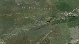
That Goosehill parcel is Duchy-owned isn't it? More interestingly, it has Field Shaft and Wall Shaft (just!) in it, both of which connect into Peakshole Sough. Goosehill Cave (probably) runs under the path.

Pindale Quarry has been up for ages, but the seller won't budge on the price, apparently, which is quite a lot for something you can't do anything with - mineral-related activity at least. Or a caravan site, which is what the seller wanted. The Moss Rake mineral rights are interesting too though - not least as there's no mineral left, but some very important mines, in excellent condition - and with huge potential for natural extensions. Does owning mineral rights then make you responsible for infilling excavated holes, or is that a landowner duty? The quarries up there have been abandoned, as far as I know - but backfilling and landscaping them would be a financial disaster. I also heard a rumour that the landowner was looking to sell the same parcel, but I haven't seen it come up yet.

It's all a bit wild west up there - it would be nice if it could all be taken into better ownership and managed with access. Hint to the richer among us ;)
 

Mark Wright

Active member
pwhole said:
It's all a bit wild west up there - it would be nice if it could all be taken into better ownership and managed with access. Hint to the richer among us ;)

BCA has more money than it knows what to do with.

Mark
 

AR

Well-known member
pwhole said:
Does owning mineral rights then make you responsible for infilling excavated holes, or is that a landowner duty? The quarries up there have been abandoned, as far as I know - but backfilling and landscaping them would be a financial disaster. I also heard a rumour that the landowner was looking to sell the same parcel, but I haven't seen it come up yet.

Both the mineral rights owner and the land owner can potentially have liability around abandoned mineral workings (as established by a number of court cases in the late 19th century), but I'm not sure whether there's case law about who takes precedence for that liability. With modern workings there may be planning conditions for restoration but if the planning authority didn't get a bond set aside for the works then odds are it won't happen, as has been the case with a number of coal opencasts where the working company has been wound up.
 

Mrs Trellis

Well-known member
As a condition of their lease from the NT at Alderley Edge the DCC have to remedy any slumping or collapse from the underlying workings. Ironically one such incident led directly to the discovery of the hoard of Roman coins and subsequently the opening up of Roman era workings (a level and a shaft with A frame timbers) which hadn't been altered by later miners.
 

pwhole

Well-known member
Here's the main section of land on Moss Rake with the mineral rights up for grabs. Strangely the map of the area on the 'Full Details' tab on the Bagshaws site doesn't correspond with the 'Area Map' tab, which seems to suggest that it's at Moss Rake East quarry, near Hartle Dale Mine:

https://www.bagshaws.com/properties/mineral-rights-s33-9hb

Also it says:
'Interested parties should read the contract and title documents, which are specific as to what can be worked.'

Well I'm interested, but I guess you have to be 'interested with cash' to get access to those. But surely that would be fluorite, calcite and baryte only? All the rake has been quarried away now apart from the mines, and there's no mineral of any value in the ones I've seen. Eidson, Sidebottom and Shatwell have worked all this to death, so I don't know what a prospector would be interested in nowadays. Puttrell and co went down Brunt Mine in 1906 looking for mineral for the landowner - I have their trip report and survey. It tallies with the survey SUSS did in the late 60s - nothing but clay and collapse. Blue Bell shaft is totally choked at 40m depth, with nothing but chert nodules and wall-collapse for company. Kittycross Mine is filled-in. The only things worth saving up there now are the map pins on the main rake below - if a mineral grabber decided to blast through those, some of the best mines in the Peak District will be lost forever.

Remember Hollandtwine ;)
 

Attachments

  • MossRake_Central.jpg
    MossRake_Central.jpg
    417.5 KB · Views: 193

AR

Well-known member
The crucial thing here will be precisely what is in the rights - to the best of my knowledge the Duchy of Lancaster have never sold off the lead rights for any ground in the High Peak Queensfield liberties, so I doubt they are up for sale here. It will certainly be spar rights, but as you mention Moss Rake has been gone over several times at surface so there's not much left of value there. Bulk mineral (i.e. the limestone) is the one that potentially might have value, but post-Backdale there's no way anyone could try and use the old sparring permissions to quarry, and any new application in that area is one I would fight to the uttermost on heritage loss grounds...
 

pwhole

Well-known member
It's certainly mostly calcite in the parts I've seen - underground that is. Not necessarily white - there's some really nice sections of yellow calcite, speckled with black - some of it is salmon-pink too, and much of it is very fibrous in texture. I don't remember seeing any fluorite though. I think most of those east-west veins tend to be fluorite-calcite-baryte heading westwards, so the fluorite would have mostly been at the Bradwell end. I think Puttrell and friends were specifically looking for baryte on their prospecting trip into Brunt Mine, but that's on a different vein.
 

Attachments

  • _IGP4869_sm.jpg
    _IGP4869_sm.jpg
    379.5 KB · Views: 153
  • _IGP9410_sm.jpg
    _IGP9410_sm.jpg
    413.3 KB · Views: 155
Interesting you mention that about the East West veins. Doesn't the Hucklow edge vein turn to Calcite west of Milldam and along Tideslow but then must be Fluorspar or certainly Barytes at White Rake...must of being something in there as remember going on John Broadbents wagon up there in the mid 80's when he was digging it out.

Sorry for going off topic but is interesting.
 

AR

Well-known member
Tideslow rake is primarily calcite (I've got a large lump of vein from High Rake Mine outside my back door) but there is some purple fluorite in amongst it - there was enough for Jack Eidson to think it worth hillocking that section of the rake.
 
Thats the part of the field over the cave Mich Ping and myself extended a few years ago, at the end of Peakshole Sough, We are re- surveying it at the moment, but it is on the Caselton caves 3D model with Goosehill cave.
The up stream passage is behind field shaft and is blocked by a clay and shale choke/ collapse, Jim L
 

pwhole

Well-known member
Just been looking again at this offer of land on Goosehill, and was struck by this line:

There are no services connected to the land, although there is a natural water supply that we are advised is reliable except during the driest periods of the year. Mains water is believed to be nearby. Any interested parties should make their own enquiries.

Now I know that area pretty well, and there are no surface outlets of any kind, anywhere near there - we had to wait for a deluge before we could dye-trace Cowlow Nick, above it, and that water went in, not out. As the field also has an open sough 5 metres below its surface I struggle to see where a landowner might be able to tap a 'natural' water supply. The shale boundary starts pretty much where the barn is - when we did the subsurface scanning of the Speedwell vent, documented in TSG19, we found that the toe of the lava flow extended way down into the lower field, and was then overlain at the very tip by a thin layer of Eyam limestone, which is seen in the tiny quarry near the barn.
 

Attachments

  • _IGP7908.jpg
    _IGP7908.jpg
    235.9 KB · Views: 163
  • _IGP5482.jpg
    _IGP5482.jpg
    472.4 KB · Views: 151
Top