

You are using an out of date browser. It may not display this or other websites correctly.
You should upgrade or use an alternative browser.
You should upgrade or use an alternative browser.
Looking for a Draenen survey
- Thread starter domestos bend
- Start date
Bob Mehew
Well-known member
For a potential replacement to the DistoX, see https://ukcaving.com/board/index.php?topic=20342.msg322254#msg322254.Huge said:Better get a new survey sorted before all the DistoXs fail and everyone has to go back to compass, clino and tape!
Stuart France
Active member
The problem is less the caving part of the job and more the drawing up part.
Can you imagine how long it takes to draw all those twiddly bits and the passage floor detail etc etc on Therion later (on a PC or equivalent) from the basic centreline survey and splays out to the walls even done with a Disto, so say nothing about having coloured layers where the 3D nature of parts of this cave renders it unrenderable in simple 2D plan view?
I am sorry to disappoint, but I am not Domestos Bend or Badlad or AM.
Bob Mehew
Well-known member
Agreed but possibly one could develop software from the 3D handling end to automatically produce plan and elevation views. Some years ago I did manage to use a program called 3D Slicer to go from a set of 2D slices to a 3D model, see below. Perhaps there is now software to go the other way to show all beneath a given slice.Stuart France said:The problem is less the caving part of the job and more the drawing up part.
Attachments
Stuart France
Active member
I write software for a living, well as part of my work. One aspect of the lockdown is that it's given me the peace and quiet at home to get on with some big software projects that have been on my back burner for many years.
The problem with major software is the complexity, timescale, and cost. Over time there is another one which is evolution. This might be due to scope creep, fresh ideas, taking advantage of new tech, fixing design mistakes of the past, need for bigger scale, lots of reasons.
There's a couple of decades already of elapsed time and probably thousands of man-hours gone into Survex, Aven, Therion which is the main platform for cave surveying. The program that already turns cave plans into elevations is Aven, and Therion can do that too. We are where we are on cave software, and it won't evolve quickly from here given that the developers are highly skilled volunteers.
It's a mistake to confuse "below a certain level", in other words a Z-axis value, with a map layer. The former is absolute separation of distance while the latter is a "logical" separation of entities. So a slicer won't work for cave surveys as it is cutting on the basis of a "knife" moving along an axis like a ham-slicing machine in the butchers does whereas what we want is separation of one (or several) passage series from another one (or many) on the basis most likely of speleogenesis - and thus their "logical" part of the complete cave rather than as absolute coordinates. Imagine what a slicer would do to the 3d-maze that is OFD2? The slices would be interesting images and a technical triumph but not useful in caving terms.
In terms of the practicalities in getting the detailed quality Draenen Survey properly published (the subject of this thread), it is going to be easier but not necessarily quicker, I feel, to fix the PDCMG than develop a new cave survey software suite. The software might take a decade or more, while the politics probably the same sort of timescale given the experience with PDCMG to date - but much less if a few fresh faces come forward to turn the page.
alastairgott
Well-known member
Ignoring the software, (as i'm perfectly happy with therion) I think you could actually resurvey Draenan and with a good team get it done rather swiftly [he says not giving any timescales].
And by swiftly, I think more than 36 sessions to get the standard shape of the cave down.(edit: that's 2km per session, so maybe a little high workrate).
[Theoretically!] 5 efficient teams working 7 days in a week might form the backbone of the cave in one week. but as Stuart says, Therion is a very powerful tool, so in conjunction with an online data repository that set of surveyors, or even a wider set of surveyors who wanted to muck in with the data could then munch through it afterwards tidying it up.
And by using a data repository the data is never lost, and is always live. So I could be working on one aspect of the survey while someone else is working on one of the (at least) 35 other sections. as long as you upload your changes when you've done your hour or so of work, then someone can pick straight up afterwards.
The software can even log prospective continuations (digs) and then output them in a database/table form.
On slicing, you're probably still going to need to actually survey the passage as Stuart says. Although topodroid does have a neat feature which I've not had chance to use yet, but that is a feature to ignore splays in the elevation drawing which are not within a certain range of angles.
(9 minutes and 33secs on this video )
it is in Marco's native tongue, but the pictures are in English")
And by swiftly, I think more than 36 sessions to get the standard shape of the cave down.(edit: that's 2km per session, so maybe a little high workrate).
[Theoretically!] 5 efficient teams working 7 days in a week might form the backbone of the cave in one week. but as Stuart says, Therion is a very powerful tool, so in conjunction with an online data repository that set of surveyors, or even a wider set of surveyors who wanted to muck in with the data could then munch through it afterwards tidying it up.
And by using a data repository the data is never lost, and is always live. So I could be working on one aspect of the survey while someone else is working on one of the (at least) 35 other sections. as long as you upload your changes when you've done your hour or so of work, then someone can pick straight up afterwards.
The software can even log prospective continuations (digs) and then output them in a database/table form.
On slicing, you're probably still going to need to actually survey the passage as Stuart says. Although topodroid does have a neat feature which I've not had chance to use yet, but that is a feature to ignore splays in the elevation drawing which are not within a certain range of angles.
(9 minutes and 33secs on this video )
it is in Marco's native tongue, but the pictures are in English
Attachments
alastairgott
Well-known member
Gah! editing my post got rid of the video!
https://vimeo.com/201826095alastairgott said:topodroid ... a feature to ignore splays in the elevation drawing which are not within a certain range of angles.
(9 minutes and 33secs on this video )
it is in Marco's native tongue, but the pictures are in English
RobinGriffiths
Well-known member
Interesting. Repositories like Git for survey data. Is there anyone doing that for a current project? Sounds ideal if you've got several teams producing the survey data.
alastairgott
Well-known member
The Imperial Team is using git for the Mijovek (sp) system https://github.com/tr1813/migresurvey, and Henry Bennett does as well for the Speleophilippines project https://github.com/speleo/SpeleoPhilippines
A number of British surveys are managed under the cave registry http://cave-registry.org.uk/ for example I could and indeed I have run the Nidderdale survey. (but only after a trip I did there).
A number of British surveys are managed under the cave registry http://cave-registry.org.uk/ for example I could and indeed I have run the Nidderdale survey. (but only after a trip I did there).
Bob Mehew
Well-known member
On a point of detail, Caveatron is used to do a 3D survey line as this is required to hang the LIDAR scan off. Indeed for me the interest is to see if one can dispense with the LIDAR part of the kit to just make a replacement for the DistoX.alastairgott said:On slicing, you're probably still going to need to actually survey the passage as Stuart says.
alastairgott
Well-known member
But it's all based off point clouds, which are mega tonnes of data, and therefore difficult to share and collaborate meaningfully online.
the slice, as stuart says doesn't take into account what you might want to add in your sketch, it would rely on you drawing this in a notepad and laboriously transferring the data once you are back at home. Imagine you've got a hading rift (sloping rift), with the main route skirting through the rift at the bottom, but a rope going up the rift. how would you denote the rope when you're just using a 3d point cloud. the same point can be made for steps in the passage, water, sumps, flowstone, a change in the floor type from sand to bedrock, etc.
all of this is captured in a good standard cave survey, the 3d point clouds are good but don't really cut it IMO.
andrewmcleod
Well-known member
On the other hand the LIDAR could be used to assist the drawing at the time of surveying. Basically, take a shedload of splays at each station and the system automatically filters them to draw only their tips as points, and only show the points with the greatest horizontal extent (for the plan). You could still add manual splays, and the 'floor' (i.e. the lowest splays at each point) could be shaded in grayscale. Then draw your lines as before... You might need some live options e.g. switch between shaded floor and ceiling, or rather than draw maximum extent draw a slice at a certain angle.
Cross-sections would be easier and better than current systems. Just draw a line on the survey and the sliced points appear. Join the dots
Cross-sections would be easier and better than current systems. Just draw a line on the survey and the sliced points appear. Join the dots
Bob Mehew
Well-known member
I quote from http://caveatron.com/alastairgott said:But it's all based off point clouds, which are mega tonnes of data, and therefore difficult to share and collaborate meaningfully online.
CAVE SURVEY TOOL - Records standard cave survey measurements (distance, azimuth, and inclination) in a single 3 second reading with station name entry.
The 3D data is seperate.
Andy Walsh
Member
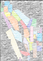
Hi i,ve got a OGOF DRAENEN SURVEY SEPT 1997-NORTH,CENTRAL AND SOUTHit is huge!!needs ironing sorry. grade 5 1inch to 75meters approx51k on survey +only one entrance but v good detail you could probably work out what's not on :thumbsup
PLEASE send an address i can send it to neighbour/yours/postoffice/shop /chamber of secrets
I hope you enjoy esp if you find stuff +makes finding way round
i will put a SAE if you can send some stamps to cover post
cheers andy
PLEASE send an address i can send it to neighbour/yours/postoffice/shop /chamber of secrets
I hope you enjoy esp if you find stuff +makes finding way round
i will put a SAE if you can send some stamps to cover post
cheers andy
alastairgott
Well-known member
Andy, for entrances, try central top left (and top right should have a couple too). Purely guessing from the lay of the land of course.
