blackshiver
Member
And thanks to the NYMCC who sat in the cold and rain manning the generator to allow this to happen


richardg said:Just seen the Survey, Excellent.... and looking forward to hearing more as you progress further in this super interesting system, including Adele and Ian Dawson diving.
Richard.
 :tease:
Moors Miner said:Adele and who? Oh you mean Snazzy Balls
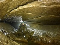
tamarmole said:Cavematt said:We suspect we are well underneath the River Dove itself, not just the watershed!
I'm impressed. Can't wait to see a survey.
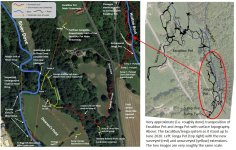
Cavematt said:Hi Tamarmole. Guinevere's Slit Sink is roughly around the lowest of the four arrows pointing to the other sinks in the River Dove. It is in the riverbed and has been dived for about 50m downstream towards The Well, reaching a choked area about 50-60m upstream of The Well (no way on located as its just very loose slabs). We assume that The Well is simply the downstream continuation of the same passage.
The Well is just off the bottom of the image under where it says 'To Bogg Hall???'. The Well drops into totally sumped, reasonably spacious passage and has been dived for about 80m downstream I think, also ending at an area of collapse, but with extremely high flow rate rushing through the boulders. The passage heads back under the river and the western hillside rather than straight for Bogg Hall so presumably it turns south somewhere soon after.
Therefore, none of the new passages in Jenga come too close to Guinevere's Slit or The Well and their associated passages. We assume the merger with the Excalibur/Jenga water lies further downstream closer to Bogg Hall.
RobinGriffiths said:So these are actually phreatic systems and not tectonic caves like the windypits? Are there other places in the NYM where such systems might develop?
Cavematt said:York Caving Club have just made our first two journals freely available as a PDF download on the publications page of our new-look website (launched just this week):
https://yorkcavingclub.org.uk/publications/
These journals are a record of all work done in the North York Moors from 2006-2013 as part of a collaboration with the North York Moors Caving Club (NYMCC, formerly Scarborough Caving Club). They cover the exploration of Excalibur Pot, and the discovery and exploration of the first 500m of Jenga Pot, as well as exploration in the River Dove valley, and an assortment of other smaller discoveries elsewhere.
Printed copies will always be available to anyone who, like me, prefers physical journals to digital.
In combination with the resources available on the NYMCC website (www.nymcc.org.uk) including MSG journals back to the 1960s, the Scarborough Caving Club and Yorkshire Underground Research Team (YURT) archives, and all the Moorland Caver cave descriptions, there is plenty of reading for anyone interested in cave exploration in the more obscure northern limestone outcrops.
Journal Three is in preparation for 2021, covering the last seven years of progress.