Mynydd y Garreg copper mine, near Kidwelly

Graigwen

Active member
robjones and myself pottered around this obscure little mine on the 25th February. It was very wet, and clothing and kit all smelled strongly of cow sh*t after.

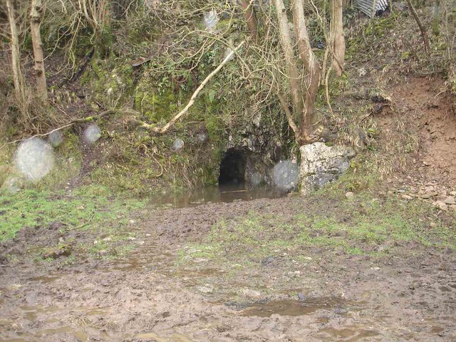
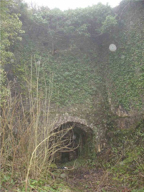
The lower level is run in a short distance from the portal and access is through a considerable depth of cow sh*t (we did not bother).
5495206915_f4cb654bc0_z.jpg


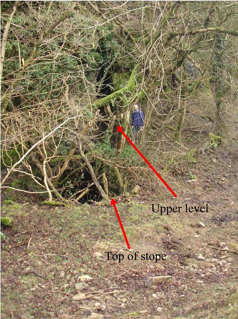
There is a large open stope which was flooded to the level of the lower adit. Discussion with the farmer established that previous visits which have found the stope dry (or at least with a significantly lower water level) followed dry periods when the farmer had pumped water from the stope as a supply for his cattle. To the right of the stope is an upper level which gives access to a shaft which enters the stope.
5495206849_17f69f42dc_z.jpg


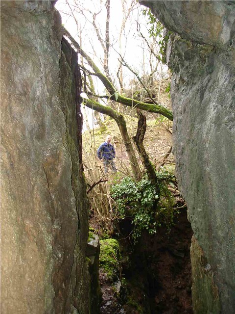
The shaft was sunk from the floor of a limestone quarry above the mine. In the upper level small calcite veins were seen, with traces of malachite and evidence of previous sampling.
5495799108_e72793c21a_z.jpg


It had been intended to dig some pits to investigate what the tip outside the lower level was comprised of, but as this is now used as a winter base for the cattle these plans were abandoned.
5495799192_18bdd5a67a_z.jpg


While the stope is large, it is suspected that only part of the material extracted was copper ore, the limestone being used to feed limekilns on the farm. Later limekilns stand by the road a few yards to the north.
5495207147_e929865237_z.jpg


The mine offers little sporting activity but is interesting geologically.
(Access only with the permission of the farmer, Mr Evans, Graig Farm.)
 

gus horsley

New member
I visited this mine about 25 years ago when it was a lot less overgrown than it is now.  I remember the stope being quite impressive and I agree that probably very little in the way of copper ore was extracted.  I found small fragments of malachite on the tips and one very tiny piece of azurite.  I got the impression that it was in reality an underground quarry which had a thin string of copper ore running through it which was mined as a by-product.
 

Graigwen

Active member
gus horsley said:
I visited this mine about 25 years ago when it was a lot less overgrown than it is now.  I remember the stope being quite impressive and I agree that probably very little in the way of copper ore was extracted.  I found small fragments of malachite on the tips and one very tiny piece of azurite.  I got the impression that it was in reality an underground quarry which had a thin string of copper ore running through it which was mined as a by-product.

Yes, it was the mismatch between the stope dimensions and the recorded copper ore output that caught Rob's attention, as well as the sharp unmineralised margins of the stope. Last week we tentatively thought oolitic beds lie immediately above and below the stope, maybe the mechanical properties of the intervening beds were better suited to produce open fractures to host hydrothermal mineralisation. Interpretation is made more difficult by the doubts about what was extracted.

When I was hammering in the upper level there was a distinct smell of sulphur, but no sulphides were seen in the rock. With the benefit of hindsight I should have dangled into the stope but it was a very unappealing prospect at the time.

A subsidiary of ELF prospected the mine a few years ago but I have not seen the report at BGS yet.  It was discussed in the Welsh Mines Society newsletters 60 & 61 (2009) and a BCRA Grade 1a survey was published in Thrutch, the Journal of Aberystwyth Caving Club < http://users.aber.ac.uk/club06/publications/thrutch/010/ >.

Any ideas about the tip material, apart from the traces of malachite? As the forerunner of the limekiln I photographed was present when the mine was in operation, we can't even assume that development rock from the lower adit went onto the tip. The pattern of small quarries along the limestone outcrop suggests that limestone for the kilns was being selected on some basis.

.


gus horsley

New member
Apart from the very few fragments of copper carbonates, the rest of the tip is limestone with a bit of calcite which doesn't really look like lode material.  The stope reminded me of a smaller version of a North Wales slate mine.  I looked for traces of copper trials in the vicinity but found none; if the stope was indeed for copper you would have thought that prospecting would have been undertaken in the area.  It's an interesting point you make about oolitic limestone as I've seen other copper workings in other parts of the UK where copper occurs in oolites as a dissemination deposit.  Perhaps that's what we have here.

Have you looked at any of the other metal mines in the area, such as Cystannog?
 

Graigwen

Active member
gus horsley said:
Have you looked at any of the other metal mines in the area, such as Cystannog?

No, despite my family coming from South Wales I barely know the metal mines there. Decades ago Mid and North Wales were my field of operations.
 

robjones

New member
Hello Gus.

The oolites overlie and underlie the stratagraphically-controlled ore deposit which is situated in a sandy limestone. There are quartz stringers with miniscule amounts of copper secondaries in the oolites; the form of the ore within the sandy limestone is unclear as it has been entirely worked out and the forefield is well below water level (if only I had sampled it in 1984 when the stope was pumped out and I undertook the survey that Graigwen links to, above!).

Examination last year of the tip from the adit showed as much quartz as calcite amongst the limestone. Coarse crystalline quartz is widespread on the stope walls and in the stringers in the underlying beds. The conclusion of a minerlaogist i took there last year, and of Graigwen and myself during our visit was that the ore body comprised a stockwork rather than being of dessimation body - the vughy crystalline quartz on the well-defined stope walls suggest a network of veins modestly-mineralised with copper sulphides (probably oxidised in the shallower portions) rather than a dessimated deposit which might be anticipated to have irregular stope walls reflecting selctive extraction of mineralised material dependant upon localised grade variations.

Cystanog and adjacent mines are conventional hydrothermal lead-zinc vein deposits in lower Palaeozoic sediments, very much of mid-Wales orefield type save for the preponderance of barytes.

An increasing amount of archival references are coming to light, from the early C18 to mid C19, indicating sparodic very small-scale production, the picture complicated by the existence of Cu-Pb trials three-quarters of a mile to the southwest that seem also to have been termed Mynydd-y-Garreg, and leases being of such wide extent that either or both sets of workings may have been referred to. The trials three quarters of a mile to the south west have been more widely referred to in the published literature than this mine. Very much an archival research project in progress at present.

Apologies to boths the mods and UKCF readers for cluttering up the forum with a metal mining thread (I didn't start it though!). In mitigation, the predominant control on mineralisation appears to be the lithological variation in the Carboniferous Limestone so this is more of a carbonate lithology matter than a mineralogiocal / mining matter.
 

RobinGriffiths

Well-known member
Hi Rob,

Mines are nice!! Did Cystanog 10years or so ago. There's a lovely lined shaft further inland from the river - no fences or anything!. Do you know if that goes anywhere? I did the level near the road, and the one over the hill which had some vertical leading to a collapsed area at that time. There were some cracking chunks of galena in there if I remember right.

Cheers,

Robin
 

robjones

New member
Hi Robin,

Am in the process of completing a survey of Cystanog.

Water level in your 'lovely shaft' is about 120 feet below collar with no landings in that distance.

The 'level near the road' must refer to the drift on the west vein, a subsidiary working of some complexity but very limited extent.

The 'level over the hill' is the Upper Penlan Level: a short way in one reaches a stope extending both up (virtually to surface) and down (to the Lower Penlan Level, c.40 feet below - the 'some vertical' that you referred to). Across the stope the drift on the Upper Penlan level continues a few hundred feet to a blind end but part way along a winze on the east (formerly connecting to the Lower Penlan Level but now blocked at about 30 feet depth) gives access to an intermediate level that extends north for a couple of hundred feet and at its end connects, via a 15 feet long crosscut west and an arkward squeeze, to the No.2 Level on the North side of the hill, the portal of which is open. The drift that comprises the Lower Penlan Level (portal slumped; access via stope in Upper Penlan Level as mentioned above) is blocked by falls a few hundred feet to the north of the 'some vertical' you mentioned - i.e the 'collapsed area you mentioned.

The only other accessible workings are (1) a short refuse-filled drift slightly east of the west level mentioned above, (2) a trial level only about 10 feet long situated a couple of hundred feet east of the west level mentioned above, and (3) an earthy shaft (resembling more a crown hole) on the sumit of the hill on the main or east vein, blocked at 20 feet depth.

There is minimal 'sporting' interest in the mine - but geologically and historically it is of some interest - hence the ongoing survey, hopefully for publication 'in due course' - my co-worker is deeply immersed in archival research into this and the neighbouring Vale of Towy mine as well as the lesser satellites and trials adjacent to Cystanog and Vale of Towy, so ultimate publication depends on him.

For completeness, I would mention that there are no accessible workings at Vale of Towy save for a very short trial level, and that the only potentially accessible workings at the surrounding satelites and trials seems to be a shallow shaft at North Towy, yet to be investigated.
 

gus horsley

New member
Hi Rob

I did a through trip in Cystannog years ago in the upper level.  I remember there were a number of small ore barrows lying around and some quite unstable workings in places.  I tried to find the adit at Vale of Towy (when there was still an engine house standing) but failed and, apart from the couple of short trials in a roadside quarry there were no accessible workings.  You could find some good barytes specimens on the dumps.

I'd forgotten about the amount of quartz at Mynnydd y Garreg - my memory isn't what it used to be.

Have you ever had a look at Carmarthen United Mine?  There used to be an engine house, huge collapsed shaft and a crosscut adit intersecting two lodes.
 

robjones

New member
Hi Gus,

I rediscovered your account of Cystanog in the Teifi Valley CC Journal vol.1 only a few weeks ago and was brought down to earth with a bump as I had erroniously imagined that the through trip was 'my' discovery!  :-[ - Shades of surveying terribly inaccessible workings in various mines in north Ceredigion, fondly imagining myself to be the first to enter them since abandonment, only too often find 'NCMC' [North Cardiganshire Mining Club] or, less often, 'SCMC' [South Cardiganshire Mining Club] inscribed in carbide.  ::)

At Vale of Towy the quarry and dumps have disappeared under a mobile home development in the twenty-odd years since your visits. The site is such a huge contrast to my first first there in 1980 when barytes littered the ground and Clay's engine house stood full height manteled in ivy. Do you have any notes or sketch plans that show the location of, and underground details of the adits you accessed?

I surveyed the surface remains of Carmarthen United in 2010. The site of the adit you recounted digging into in the TVCC Journal vol.1 (which, like the Vale of Towy description, I only rediscovered a couple of weeks ago) was barely recognisable due to the accumulation of over two decades of leaf mould. Your description of mud, water and very limited accessible workings has not inspired me to return to reopen the adit!  Save for a goodly portion of the development rock dump having been removed, the site appears to be untouched since your visit - and, indeed, essentially untouched since abandonment. There never was an engine house at Carmarthen United, only two wheelpits, the impressive masonry pit for the upper of which certainly verges on the scale of some engine houses. Its a geologically intriguing location for a significant lead mine - and its a gresat pity that there are no accessible lode exposures. Was the lode exposed in the level? - I may yet feel obliged to enter the gloop....
 

gus horsley

New member
The two adits at Vale of Towy were in a quarry on the south side of the main road a few hundred yards upvalley from the site.  One was very short and the other went a couple of hundred feet with no significant mineralisation, although I seem to remember seeing a tiny stope at one point.

At Carmarthen United the adit is a crosscut which heads towards the shaft (where it is run-in), which is presumably on the main lode.  There are two drives on lodes which are little more than thin strings with no visible ore.  I wouldn't like to think what state it's in but it was very wet a few decades ago.
 
Top