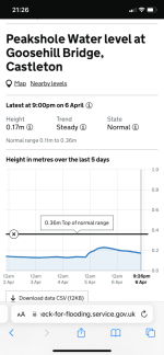
Environment Agency Water Depth Logger in Castleton

DCA

Active member
The Environment Agency have at last installed a water depth logger at Goosehill Bridge, Castleton. This is now live at:

https://check-for-flooding.service.gov.uk/station/9595

The water depth is updated every 15 minutes, and the datum is the crest of the weir that was installed in 1984/5 by the TSG and a group from Manchester Polytechnic. The metre ruler on the left bank of the river when looking downstream from the bridge has the same datum, so the levels on the web should be the same as the levels on the ruler. The outputs contributing to the total flow are Peak Cavern, Slop Moll, Peakshole Sough and Russet Well.

For those interested in the Bagshawe Cavern outflow, there is also a site on Bradwell Brook:

https://check-for-flooding.service.gov.uk/station/9475
 

al

Member
Interesting! Is that actually showing the pulsing flow coming from the Speedwell risings with the variations that can be seen?
When Mr Fireguard and I were doing some work for Speedwell down in the Bottomless Pit between pulses we worked out that, on that day, the pulse occurred at approximately 30 minute intervals (IIRC!), so it might be possible, but, there again, a 15 minute sample could miss the pulse altogether. Also I'm not sure whether the pulse is as noticeable at the bridge as it is at the Bottomless Pit.
 

wellyjen

Well-known member
Do we know what depth corresponds to the first step down to the water, just above the bridge that is often used as a guide to water conditions in Peak?
 

al

Member
This is very useful! As well as showing the current water level, it also indicates the highest level recorded level, plus what the top of the "normal" range would be - additionally, it shows a graph of the previous couple of days.

This is all very easy for a non-scientific person (e.g. me) to understand, and should give a better idea of conditions in Peak than the old "step" method which we've all been using for many years. I've been into Peak as far as the Upper Gallery when the old step was a couple of inches beneath the surface, so it is obviously possible for Slop Moll to be running high while the Peak main streamway is still at normal levels.
 

Scud

Member
No not yet but that is on my and John Gunn's list to do in a few weeks time.
The well-known ‘cavers step’ upstream of Goosehill Bridge that cavers use for checking the water levels prior to a trip into Peak Cavern has been levelled in as 0.17m on the ruler so if the EA gauge is approaching or over that depth, and the weather forecast is bad, you may wish to abort your planned trip.

Picture of the step below and the EA Water Depth Logger.

Peakshole Water Step, Castleton - 240319_lg.jpg
EN Gauge Castleton - 240319_crop_lg.jpg
 

alastairgott

Well-known member
That tallies, I let people in on Sunday 17th just gone, and it recorded 0.16m and they were fine. Was nigglingly concerned about potential rain, but briefed the experienced team, so at least half of the team knew the drill. But gut feeling said they’d be fine.

I’ve been in on an over the step dry day with no rain forecast, quite fun! Good resource the waterometer we’ve all got now, sometimes I get a bit sidetracked from what the weathers been like, so good to get a reset back to reality.
 

andrewmcleod

Well-known member
So:
If the water level is below the step, and no rain is forecast, it's fine.

If the water level is above the step and train is forecast, it's not fine.

Then what about if water is below the step but rain is forecast?

Or is water is above the step but no rain is forecast?
 

pwhole

Well-known member
I've been in Peak about 500 times and never got stranded, so it's pretty rare it's ever that bad. And a good excuse to check out the geology in Treasury Chamber if it does happen :)
 

wellyjen

Well-known member
I've been in Peak about 500 times and never got stranded, so it's pretty rare it's ever that bad. And a good excuse to check out the geology in Treasury Chamber if it does happen :)
And the chocolate in the dump does get replaced regularly!
 

alastairgott

Well-known member
So:
If the water level is below the step, and no rain is forecast, it's fine.

If the water level is above the step and train is forecast, it's not fine.

Then what about if water is below the step but rain is forecast?

Or is water is above the step but no rain is forecast?
Sounds like a maths problem: If Sandra has 5 sweets and molly has 7, how many holidays has Becky been on?
 
In Bagshaw today and water was just about at the bottom of the Dungeon pitch surprisingly . Interesting how different areas get the rain.
 
Top