

You are using an out of date browser. It may not display this or other websites correctly.
You should upgrade or use an alternative browser.
You should upgrade or use an alternative browser.
Peak District - Wezzit?
- Thread starter Rob
- Start date
Outdoor Miner
New member
Is it Groaning Tor?
mch
Member
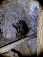
The water appears from a slot part way up on the right hand side of the adit near the end (shortly before it intersects the Matlock Lower Lava). In times of heavy rain/snow melt it also pours out of a slot high on the right hand side a few yards before that point. At these times it can be several inches deep flowing down the level. It sinks in a floor level slot on the right hand side of the adit (as shown in the photo). It can also emerge after heavy rain from 2 points in the small levels off to the left before the adit cuts the Matlock Upper Lava and this water sinks in 2 places on opposite sides of the adit just past the collapse near the entrance. The purpose of the dye trace was an initial attempt to determine the course of the water that sinks on the far side of the Matlock Upper Lave. Detectors were placed in the spring opposite Slinter Wood Cottage, in Bonsall Brook a few yards upstream of the spring, and in Bonsall Brook roughly opposite Owlet Hole Gate (as it has been thought that a sough once emerged there although there seems to be no documentary evidence). All detectors were negative, but at least it showed that the often-expressed view that the Hallicar Wood Level water emerged at the spring was wrong (although the water that emerges in the side passages may do so as it may follow a different course sinking as it does on the other side of the Matlock Upper Lave).
Outdoor Miner
New member
mch said:Well done Outdoor Miner, it is indeed Groaning Tor Level (aka Hallicar Wood Level). Over to you.
Just been recently so had an advantage!
OK, here's mine....wezzit folks...
Attachments
Outdoor Miner
New member
Ha ha, well done Mark. Correct you are. That was perhaps a bit too easy. Over to you kidda...
skippy
Active member
Cantclimbtom
Well-known member
Your definition of Peak District is casting the net a bit wide with that IanP... Almost like you're wishing you were part of the Peak perhaps??
(admiring the pic though, as dihedral was my first caving trip, fond memories)
(admiring the pic though, as dihedral was my first caving trip, fond memories)