Deep Well - Pridhamsleigh

Pitlamp

Well-known member
Thanks; it's interesting if a road building scheme affected water levels in the cave. What sort of difference are we talking about; a metre or so? If that's the case then it couldn't account for stals at -12 m.

Navy divers eh? If they weren't actually cavers, would they be able to identify stal anyway.

I wonder if it's worth my asking CDG members (via the website) if anyone's actually seen these things in there.

Out of interest, what's the level of the Prid lake water surface relative to sea level?
 

Cartwright26

New member
Another caver i was with was able to get into the roof voids by pulling himself out of the water thats how high it was!!!
 

Pitlamp

Well-known member
Thanks, is that "-44" as in "44 m below the level of the entrance"?

Really what I'm interested in is how far above sea level the water surface in the Lake is normally.
 

Les W

Active member
Pitlamp said:
Thanks, is that "-44" as in "44 m below the level of the entrance"?

Really what I'm interested in is how far above sea level the water surface in the Lake is normally.

Mr Oldham's Concise Caves of Devon, gives an elevation of 200 feet, which I assume to refer to the entrance
also a vertical range of 50 feet (which I assume is to the water) or a vertical range of 170 feet if diving.

Not sure how helpful that is.

The other thing to consider, apart from the construction of the bypass, is that the river is very close to the cave (although on the other side of the dual carriage way) and will almost certainly have some effect on the water levels in the cave...
 

jessausten

New member
Nice to see my original post has been so active!

Off to Prid again this evening in search of the mystery pool.

Aiming to get there around 19:00 if anyones about - always fun meeting fellow Cavers!

Sent from my SM-N9005 using Tapatalk


Pitlamp

Well-known member
Les W said:
Pitlamp said:
Thanks, is that "-44" as in "44 m below the level of the entrance"?

Really what I'm interested in is how far above sea level the water surface in the Lake is normally.

Mr Oldham's Concise Caves of Devon, gives an elevation of 200 feet, which I assume to refer to the entrance
also a vertical range of 50 feet (which I assume is to the water) or a vertical range of 170 feet if diving.

Not sure how helpful that is.

The other thing to consider, apart from the construction of the bypass, is that the river is very close to the cave (although on the other side of the dual carriage way) and will almost certainly have some effect on the water levels in the cave...

Sorry folks I was away from my PC most of yesterday for a variety of reasons.

Les - your post above is exceptionally useful - thank you.
 

mrodoc

Well-known member
I have just been looking at Hooper's 1957 survey and see that the Zero datum is the entrance so the 44 at the surface of the Lake is 44 below that. As the entrance slopes significantly it would be important to know exactly where the datum was established. From there you can then estimate the height above mean sea level.
 

The Old Ruminator

Well-known member
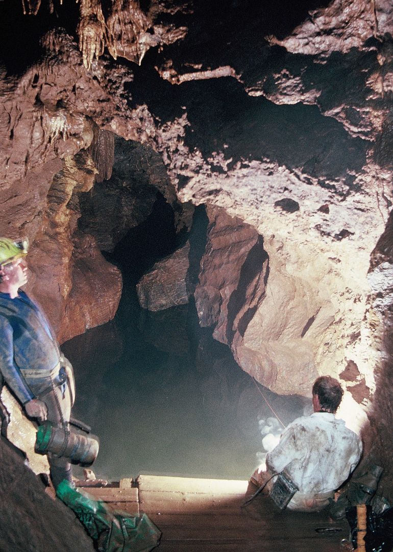
For the record this was the lake level on 16th October 1990.


My maximum depth on the dive was 29 metres but I cant remember if that was in the chamber or at the bottom of the lake.
 

Pitlamp

Well-known member
Thanks - that's rather an attractive looking sump pool! (Don't think I've ever actually seen a photograph of it before.)

Regarding the altitude of the Lake surface, I think Les has answered that one. If it's so far above sea level then the existence of submerged stal is unlikely to be related to falls in sea level (in glacial periods) with related falls in sump level. So if those stals do exist down to -12 m there must be another mechanism.

A couple of CDG members who dive there now and again have contacted me and kindly offered to make a point of looking next time they're there. I've also been pointed to a DSS reference which mentions stals at -3 m at least.
 

Joe90

Member
Id say much more than 3 metres from what i have seen down there, I have seen it a little lower than that photo, and for height gained after coming out of the cellars area and into the lake chamber i was waist deep. I believe Cartwright has swam right through.... Might be wrong...

Modified to add, that would give roughly about 5/6m difference i would think
 

Pitlamp

Well-known member
Thanks for that. I spent a useful hour last night going through all CDG Newsletter dive logs for the Lake in Prid. Several refer to the level of the water relative to the platform; the greatest difference suggested in all these logs is 3.25 m (2.5 m above to 0.75 m below). Of course divers may not have visited in the driest or wettest conditions.
 

mrodoc

Well-known member
Bear in mind the platform has been built and rebuilt over the years but roughly in the same place. If it is any help on my first visits in the late 60's the water would be below the base of the platform. That's when we saw the young eel.
 

Cartwright26

New member
When i went appx jan 3rd 2014 that archway on the right o that picture was under water in fact the arch in the centre there was around 12 inches of clearance between that and the water!! There is a dark rubbish video on you tube to give you an idea
http://youtu.be/4jszaqqP_A4
We have an enormous amount of rain!!
 

mrodoc

Well-known member
For those who are interested a small group of us visited Prid yesterday. My first visit for 5 years according to my log. Water levels were high but not as high as I have seen them or as high as they were 4 days ago apparently. The water levels had dropped by 1.5 metres probably which considering the volume of water in the cave is interesting. Some years ago I observed a marked flow from the lake into the Mystery Pool series. I have always wondered if the increase drip of water into the lake is sufficient to account for the water level rise and I am now thinking we are missing something. In Deep Well yesterday there was an equally strong flow out of Flooded Rift suggesting water flows through the system from the Lake across to Flooded Rift and then out via the Well. It will be interesting to see if the mud choking the floor of the Deep Well is therefore flushed out with time.

As regards points of water ingress into the Lake I have been told that one caver noticed right at the far end of the Lake, on one occasion, a distinct jet of water hitting his feet. I don't know what conditions this was under but is interesting. It is particularly interesting in relation to a report published in a Cerberus Journal in April 1992 (referenced to a PCG Newsletter of the winter of that year) that a Paul Craggs had, in a series of dives, explored about 45 metres of passage only 6 metres below the diving line leading to Prid 2.  Enquiries regarding this recently suggest this was a spurious report but if there is any truth at all it might suggest a location for the point at which water enters the system. If anybody has the original PCG report on can shed light on this I would be interested. It is worth noting that there is also a diveable sump in the far reaches of DogHole.
 

Pitlamp

Well-known member
That's useful, thanks. How high do you reckon the water was 4 days ago relative to the present diving platform? I'm still trying to establish the difference between highest and lowest water levels as closely as possible. Given the appalling weather you've had to suffer in the south west lately, I guess this a good time to be asking about highest water level.

Along these lines - what's the lowest water level below the platform anyone can remember?
 

mrodoc

Well-known member
In The Old Ruminator's 1990 image one can see two rock projections (The Groynes) just clear of the water. In low water conditions these are well clear of the water such that you can swim under them. The water doesn't start to get deep until beyond them. So on occasions the Groynes can be well above water level and at other times totally submerged such that the water reaches only a metre below the arch above them as in the photo taken yesterday. Go to this link and after scrolling past the other pics you will find Prid on the end and an image that shows the arch above the Groynes very clearly.
https://www.facebook.com/media/set/?set=a.466934199810.254186.772704810&type=1&l=a3fdfd8e39
I reckon that's the best way to estimate variation in water table (yesterday's shot was not the water at its highest either!)
 

Cartwright26

New member
I certainly experienced the undercurrent three nights ago but not last night i was going to start a new thread! I still maintain that when i went down at the beginning of january it was of record height as seen in my video the top arch was 12 inches above the water, in the above photo from ruminator those guys would of been in the water!
 
Top