Water Levels in Stoney Middleton Caves this week

Rob

Well-known member
I'd be interested to see that report, as i'm sure would others.  (y)

If i'm not mistaken in the 70's the Merlin streamway wasn't accessible or known to cavers, at least upstream of sump 1? If so any report of steps going down to a streamway may well be an unknown access into that stream? Although that is definitely not left at that T-junction...
 

martinb

Member
I found the article: Three centuries of open access to the caves of Stoney Middleton Dale Site of Special Scientific Interest, Derbyshire. Pub. Geological Society. 2014/2015, I've only got a paper copy, although it should have been published online.

Quote:

....'The Merlin Cavern is of heritage interest, namely in respect of its use for a time as a Grotto...' (Bray 1783, Pilkington 1789, Farey 1811, Cowen 1910, Wood 1842, Rieuwerts 1960, J Rieuwerts Pers. Comm.)

Thomas Cowen describes the 'Merlin Cavern' as...'The cavern which is rich in stalactities and stalagmites, was reopened a few years ago, but the roof has now fallen in places.' (Cowen 1910, p 29.)

....'The author noted the remains of a wooden staircase on the floor of the adit level, which would have been used to gain access to a small solution cavity above..' (J. Rieuwerts, pers. comm.) An annotation also states that ...'Jim R says the stair went down'

And....'It is possible however that the instability on Stub Scrin conceals the precise location of the grotto referred to above, as there is no evidence that the Merlin Streamway passages were used as a grotto.'

The rift is interesting, there is a lot of loose fill/backfill on the floor, possibly miners waste. It is easy to remove with plenty of stacking space. As said, having removed a good meters worth of rock, the is evidence of a man made feature - a dry stone wall.

The public house that used to exsist on the corner of Eyam Dale - The Bull? - has references to a streamway being accessible through the cellar of said house.

Also John Beck stated that when he found Gimli's Dream, there was no evidence of any previous access by man.

So, what and where was the 'grotto' referred to above? Was it accesible via the rift and subsequently backfilled?

Where is the lost streamway in Merlins and the pub?
 

martinb

Member
Rob said:
I'd be interested to see that report, as i'm sure would others.  (y)

If i'm not mistaken in the 70's the Merlin streamway wasn't accessible or known to cavers, at least upstream of sump 1? If so any report of steps going down to a streamway may well be an unknown access into that stream? Although that is definitely not left at that T-junction...

The reference to the streamway indicated that it wasn't Merlins Streamway - but a parallel watercourse.

The article has been published online at http://sp.lyellcollection.org/content/early/2014/10/23/SP417.3 but requires a login and/or purchase to access. I have a paper draft copy.


Having reviewed my own scribblings above, if there is another watercourse/streamway running lower/parrallel than the current Streaks/Nickergove/Merlins/Carlswark streamway, that could account for a number of unknown/unaccounted for annomalies in where water goes at various points in the Dale.
 

richardg

Active member
Another stream way?
Would this be the "Northern Streamway"  taking the streams that sink along the shale margin, eg Waterfall Swallet etc ?
 

martinb

Member
richardg said:
Another stream way?
Would this be the "Northern Streamway"  taking the streams that sink along the shale margin, eg Waterfall Swallet etc ?

Nope.

In Stoney Middleton Dale, there is the streamway that links Streaks -> Nickergrove -> Merlins -> Carlswark. What is being hypothesised in another parallel streamway which has been referenced to in the past. There are a number of places along the dale where water sinks and doesn't appear fully or in part in the Streaks -> Carlswark streamway.

If I remember rightly, most of the water off the shale margin behind Eyam, Hucklow, etc, finds its way to the Boil Up and thence to Moorwood Sough....although there is another sough slightly further north - Stoke Sough? - that may take some water off the shale.
 

Rob

Well-known member
richardg said:
Another stream way?
Would this be the "Northern Streamway"  taking the streams that sink along the shale margin, eg Waterfall Swallet etc ?
The Eldon possibly found that in Doom, or at least the stream from Hungerhill Swallet. That water is now captured by Glebe and drains out of Moorwood Sough.

A natural downstream continuation heads south but was full of sediment. Good dig i reckon...
 

AR

Well-known member
The flow out of Stoke Sough these days isn't particularly great, there's a collapse in the sough around Old Engine Mine according to Doug's notes and the air quality in the sough beyond the second air shaft drops off pretty quickly - we turned back when the 4-gas said 11% Oxygen... Then there's Magclough Sough further north than this and at a higher level; I've never visited the tail so I don't know what flow (if any) still comes from this one.
 

pwhole

Well-known member
This is from an unpublished report by Jim R for the Peak Park on the mining history of the Eyam area, written in 2007, which may clarify the ladder issue:

Merlin Mine and Cavern in Eyam Dale is much frequented by explorers and was shown to visitors. Farey [1811] recorded it as a Cavern and beautiful Stalactites, Stalagmites etc. Mr. Edwin Maltby, an old Eyam lead miner related to the writer in the early 1950s that there was a lower series in the mine containing fine caverns. These passages were of course the Merlin streamway and ?Gimli?s Dream?, many years before they were re-discovered by cavers. The mine exploited Merlin Pipe, Sycamore Scrin and Stub Scrin. The earliest documentary evidence dates from 12th June, 1788 when:

Joseph Brittlebank Bought for Mr Wm Longsden all those Meers of ground that Belong to Francis Rowland upon the stubs scrin title that Rainges west from Mr Longsdens west fence in auttencroft for the sum of foure shillings. On the reverse is endorsed: For W.M. at Merlin?s Cave [SCL Bag 587/44].

Ore production began at the same time at Merlins Cave. The year 1788 saw 46 loads 5 dishes raised, but 1789 and 1790 were better, measuring 149 loads 3 dishes and 141 loads respectively. Production continued until 1797, total output being 409 loads 2 dishes, inclusive of Lot ore [Chats, Dev Coll]. A mine plan dated 1819 shows the line of Stub Scrin or Merlin Caverns [SCL, Bag 199]. The mine and caverns were developed as a tourist attraction about 1893 by Wilmot Parkin who was involved with the Grindleford-Totley Tunnel on the Hope Valley railway line. A footnote in Wood?s, History of Eyam [7th edn, 1895], comments that the cavern was then open to the public.

When the writer and companions first explored the mine in the 1950s, an old wooden stairway, used for visitor access into a cavern above the main drivage along Merlin Pipe, was still in existence.
 

martinb

Member
pwhole said:
This is from an unpublished report by Jim R for the Peak Park on the mining history of the Eyam area, written in 2007, which may clarify the ladder issue:

Merlin Mine and Cavern in Eyam Dale is much frequented by explorers and was shown to visitors. Farey [1811] recorded it as a Cavern and beautiful Stalactites, Stalagmites etc. Mr. Edwin Maltby, an old Eyam lead miner related to the writer in the early 1950s that there was a lower series in the mine containing fine caverns. These passages were of course the Merlin streamway and ?Gimli?s Dream?, many years before they were re-discovered by cavers. The mine exploited Merlin Pipe, Sycamore Scrin and Stub Scrin. The earliest documentary evidence dates from 12th June, 1788 when:

Joseph Brittlebank Bought for Mr Wm Longsden all those Meers of ground that Belong to Francis Rowland upon the stubs scrin title that Rainges west from Mr Longsdens west fence in auttencroft for the sum of foure shillings. On the reverse is endorsed: For W.M. at Merlin?s Cave [SCL Bag 587/44].

Ore production began at the same time at Merlins Cave. The year 1788 saw 46 loads 5 dishes raised, but 1789 and 1790 were better, measuring 149 loads 3 dishes and 141 loads respectively. Production continued until 1797, total output being 409 loads 2 dishes, inclusive of Lot ore [Chats, Dev Coll]. A mine plan dated 1819 shows the line of Stub Scrin or Merlin Caverns [SCL, Bag 199]. The mine and caverns were developed as a tourist attraction about 1893 by Wilmot Parkin who was involved with the Grindleford-Totley Tunnel on the Hope Valley railway line. A footnote in Wood?s, History of Eyam [7th edn, 1895], comments that the cavern was then open to the public.

When the writer and companions first explored the mine in the 1950s, an old wooden stairway, used for visitor access into a cavern above the main drivage along Merlin Pipe, was still in existence.

Ah, that may be the reference my caving buddy was alluding to.

I still wonder if there is something else to the left along Stub Scrin. There is a draught coming up from the floor between rocks. There is evidence of human intervention beneath the current floor.

Also if the public were accessing the 'wooden stairway, used for visitor access into a cavern above the main drivage along Merlin Pipe..' what and where is that? I'm unaware of anything above Merlin Pipe along the blind passage towards Merlins Streamway?
 

pwhole

Well-known member
OK, I've had a chat with Jim this afternoon, and he said the 'up' stairway was in the main pipe level, and is the natural cavity shown on his old sketch survey in PDMHS Bulletin 1-2:

http://www.pdmhs.com/docs/default-source/bulletins/bulletin-01-2/bulletin-1-2.pdf?sfvrsn=6

He said that the 'down' stairway, described by Edwin Maltby, was in one of the three shafts in the floor, but may not be the one currently used to access Gimli's Dream. I can't imagine it would be, with the flat-out crawl at the bottom of the tight stope - a bit hardcore for a showcave. So was it one of the other two, now backfilled above the connection? Jim said that in that regard, it was as it is now, when he was visiting in the early 60s, and there was no obvious way on.

I do have some notes from Doug Nash's files in pdf format which describes two visits made by him - one in 1950, and one in 1960. They may have been summarised into the current COPD entry, but as I've only been once, and not entered any side-passages, it's difficult for me to tell.
 

martinb

Member
pwhole said:
OK, I've had a chat with Jim this afternoon, and he said the 'up' stairway was in the main pipe level, and is the natural cavity shown on his old sketch survey in PDMHS Bulletin 1-2:

http://www.pdmhs.com/docs/default-source/bulletins/bulletin-01-2/bulletin-1-2.pdf?sfvrsn=6

He said that the 'down' stairway, described by Edwin Maltby, was in one of the three shafts in the floor, but may not be the one currently used to access Gimli's Dream. I can't imagine it would be, with the flat-out crawl at the bottom of the tight stope - a bit hardcore for a showcave. So was it one of the other two, now backfilled above the connection? Jim said that in that regard, it was as it is now, when he was visiting in the early 60s, and there was no obvious way on.

I do have some notes from Doug Nash's files in pdf format which describes two visits made by him - one in 1950, and one in 1960. They may have been summarised into the current COPD entry, but as I've only been once, and not entered any side-passages, it's difficult for me to tell.

Cheers Phil

That's very interesting, especially, as they surmised that there could be a 'supposed sough' running behind the pub, also the reference to the 'Giants Stairway' which obviously goes up in a easterly direction, I wonder if it went down in a westerly direction - which is where I found a 'dry stone wall'.

I didn't realise there was also a 'mound', so perhaps an investigation may be in order.

I realise where the 'up' stairway is, just past the 'bend' mentioned there is an upper cavity. I clambered up there for a shufty last year. Nowt to write home about.


Mark

Well-known member
Extracts from Johns diary

Sunday 22nd December 1974.

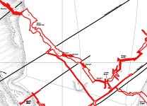
Yesterday?s party attacked the north east end of Stub Scrin in Merlin. Mark and Kevin descended shaft S3 (as denoted by King, 1962) but it was blocked with boulders. They tried clearing a trial about 10ft down, without success. The choke beyond may be a shaft to surface. Kevin began clearing it. We thought this shaft must be close to the one further up Eyam Dale, but it turned out that it must in fact be in the fields of Auton Crofts.  There are two other shafts in between, in fact.

Monday 19th April 1976.

Keith and I went to investigate the big spoil heap. Ted arrived, and we dug, prodded, climbed trees for vantage points, and even divined, without success. We didn?t find the shaft.

We went for a brew, then down Merlin S3, where we uncovered a fissure with a slight draught. A dig is planned. We went to the Cowlishaw Shaft. Ted climbed down and listened, but despite a dangerous cessation of breathing, nothing was heard of the stream. We returned to Glebe Cottage.

Saturday 18th September 1976.

Keith, Mark and I went to dig at shaft S3 in Merlin. Pete Whatley etc went up to Sump Five and report Five full but static, and Shag's Sump still down.

The S3 dig went smoothly, and we broke into a level to the north east. It ended after a few feet at a further blockage, and the draught seemed to come down through this.

Friday 31st December 1976.

Chris, Mark and I went to organise the dig in S3 in Merlin. A bolt was placed in the roof, a large bucket was mounted with a double pulley, and we began to move rocks.

The middle level was largely filled, as was the one found on the last trip at the bottom. Mark considered the collapse here impossible, and it was walled off. There were some epic collapses during backfilling at the bottom. An undercut was found on the south west side, but may close after a few feet. We left at about 3.45, washed at Hawkenedge, and returned to Eyam.

Sunday 2nd January 1977.

Quite an early start. Chris arrived back from Chesterfield, and Mark, Chris and I set off to work on S3 in Merlin. Keith and I stayed in the level 10ft down, where backfilling is going quite well.  Mark and Chris continued to dig down, and reached ginging on the south west well. The shaft became very much narrower, and the fill a lot muddier.

Slots and holes for stemples occur in two regular parallel sets in front of the ginging, and two new stemples were placed for safety. It is intended to build a platform for additional protection of diggers on the next trip, and to board up bad ginging in case of any collapse.

According to the geological section recorded in Shaft S2, we should only be a short distance above the anastomosed bedding plane which roofs the stope leading to the streamway. There is likely to be at least a trial on this bed.

Bolts are now needed for belaying the ladder; the present belay (a log) means that the ladder hangs over loose rocks. The log can be used for stemples.

Saturday 8th January 1977.

Keith, Mark, Chris and I went to the S3 dig in Merlin. We reached the base of the ginging, where a rotten timber fell out.

Andrew and John arrived, and two timbers were set in. Timbering is planned for Wednesday.


Saturday 22nd January.

Mark, Chris and I went to S3 in Merlin, as Chris was only equipped with dry grots. We did a lot of digging, and put in a new bolt, but the level we are filling is in need of retaining timbers. We came out fairly early.


Then we started digging the deep shaft entrance into big dig

S3 might be worth another look?
 

Rob

Well-known member
Mark, any idea where in "Sump 3 in Merlins" this level is? Those report suggest it may be to the NE of the passage (i.e. right as heading up stream), but i don't know of anything going off, nor is anything marked on John's survey...
 

Attachments

  • Merlins.JPG
    Merlins.JPG
    182.1 KB · Views: 184

Mark

Well-known member
S3 is shaft 3 on stub scrim, beyond the shaft down to gimlis dream and the stresmway
 

2xw

Active member
NB:

Yesterday Merlin streamway was resumped. Big dig in JS passage was the typicl face in the water wet crawl.
 

martinb

Member
Just been reading Descent issue 256, and the Training Weekend in Stoney Middleton Dale.

Prof. John Gunn injected dye into Cucklet Delph Top Sink with receptors in Merlin Streamway and Moorwood Sough Tail. the following day the receptors were retreived and the one in Moorwood Sough was positive, the one in Merlins Streamway wasn't.

More credence to another sough/streamway in Stoney Middleton Dale?  :-\
 

2xw

Active member
martinb said:
Just been reading Descent issue 256, and the Training Weekend in Stoney Middleton Dale.

Prof. John Gunn injected dye into Cucklet Delph Top Sink with receptors in Merlin Streamway and Moorwood Sough Tail. the following day the receptors were retreived and the one in Moorwood Sough was positive, the one in Merlins Streamway wasn't.

More credence to another sough/streamway in Stoney Middleton Dale?  :-\

Not really, it just means top sink water flows directly to the boil up - or water could pop in anywhere after Merlin streamway into John Smiths.
Presumable, a second streamway would not flow into the boil up - the way to test this would be to have multiple detectors inside Glebe?
 

martinb

Member
Not so much Stoney Middleton, but Peak Cavern, had a splosh around Peak, water was as high as I've ever seen it, apparently Lumbago Walk was closed yesterday (Saturday 10th).

Far Sump was flowing over the top for the first time I've seen, normally it trickles through, Inner Buxton Water Sump was backed up way past Tom Brown's Inlet - a good 50m+, and the streamway was tough going against the flow. Treasury Sump was well silted up with less than a meters headroom down to the water. Water was gushing out of Lake Passage into main Streamway.

Muddy Ducks was as normal, wet and 'orrible.  :yucky:
 
Top