ILoveCaves
Member
Hey all!
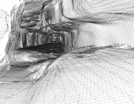
So whilst I've been working on the data sent in by quite a few of you for RoMine, I have continued to look into and utilise LIDAR, alongside photogrammetry, Here is a very early piece of my work from Jigsaw Passage (ogof daren cilau).
Long story short, the data produced can create routes that a smartphone would be able to follow, both using AR, but also localised coordinates.
Will share some more news later this year when the app is operational")
We really are at a new age of speleological research and recording!
Anyone else been working on similar projects recently?
- See the Cave Video Below -
https://www.youtube.com/watch?v=smd2qp509wA&feature=emb_title
- Other Examples -
https://vala-heritage.com/?page_id=593
So whilst I've been working on the data sent in by quite a few of you for RoMine, I have continued to look into and utilise LIDAR, alongside photogrammetry, Here is a very early piece of my work from Jigsaw Passage (ogof daren cilau).
Long story short, the data produced can create routes that a smartphone would be able to follow, both using AR, but also localised coordinates.
Will share some more news later this year when the app is operational
We really are at a new age of speleological research and recording!
Anyone else been working on similar projects recently?
- See the Cave Video Below -
https://www.youtube.com/watch?v=smd2qp509wA&feature=emb_title
- Other Examples -
https://vala-heritage.com/?page_id=593