• BCA Finances

    An informative discussion

    Recently there was long thread about the BCA. I can now post possible answers to some of the questions, such as "Why is the BCA still raising membership prices when there is a significant amount still left in its coffers?"

    Click here for more

Project Baseline South Wales Caves (Porth Yr Ogof / LNRC)

christine

Active member


Hi Everyone

I am setting up a thread designated to Project Baseline, which aims to contain information about the project, discussions about Project Baseline and give volunteers a platform to engage with the project.

In this post, I will explain what the project is about and how we are implementing it in the UK.
Some of you may have heard my talk last year at Hidden Earth about Project Baseline - and we are now getting cavers and cave divers wanting to become involved in making observations at the project sites.
I appreciate that not everyone uses Facebook, so this may act as a platform for those who prefer to use a forum and PM system instead.

So, if you will, here is everything you need to know about Project Baseline  :)

What is Project Baseline?

Project Baseline is an initiative set up by a not for profit organisation called Global Underwater Explorers (GUE).     
http://www.globalunderwaterexplorers.org/.
GUE is committed to three organizational pillars: Education, Exploration, and Conservation.
The initiative was brought about by Dr Todd Kincaid in 2009, one of the founding members and exploration cave divers of Wakulla Springs, Florida.
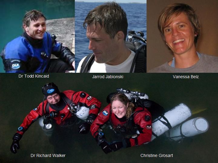

[size=8pt][size=8pt]Clockwise from top left: Dr Todd Kincaid, WKPP member and founder of Project Baseline.  Jarrod Jablonski, founder of Global Underwater Explorers and WKPP exploratory diver. Vanessa Belz, Project Baseline manager. Dr Richard Walker (CDG/GUE technical training director) and Christine Grosart (CDG/GUE), Project Managers for Project Baseline South Wales Caves.
[/size]

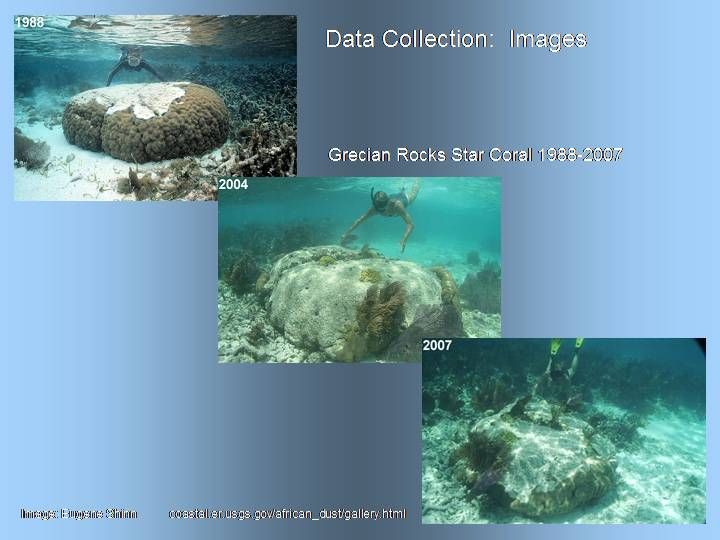
He was often hearing tales of this 'pristine' spring from people who had visited decades before and people visiting today were still describing the same spring as pristine. But it was obvious from photographic data that something had changed.
A green algae now seemed to plague the site and vizibility appeared to have been reduced.
Comparing photographs seemed to be the only way of evidencing the change in water quality.
[/size]
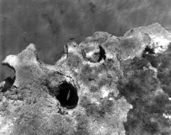
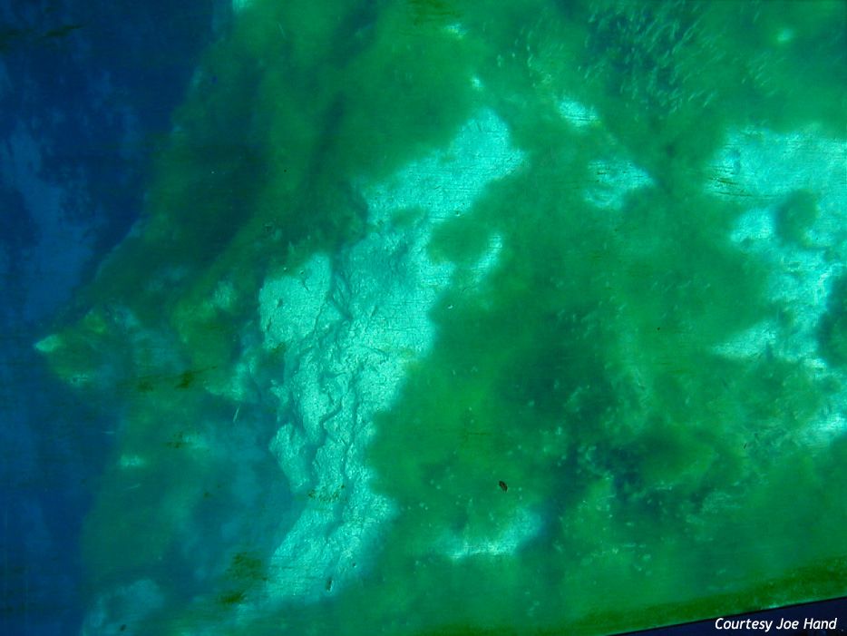

Comparative photos several decades apart of the same site, Wakulla Springs, Florida

It was obvious that aquatic sites were changing over time, but nobody was really noticing during that change and the 'Baseline' for what was 'pristine' for a site, was shifting.
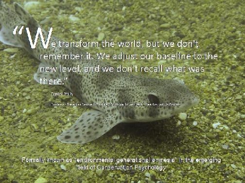


This phenominon of 'Environmental Generational Amnesia' is the sole basis of Project Baseline.

How does Project Baseline work?

GUE encourages and supports community members who are vested in the long term oversight of local aquatic environments. Volunteers record and catalogue observations of these places into a widely accessible database. It is their vision that through extensive, long term documentation of these areas, the scientific and non scientific community will listen to the story of water that is being influenced and told by generation after generation.

The Vision

[size=12pt]To realize exhaustive documentation of aquatic areas all over the world, allowing future generations of people to know the state of water through time.


Our Mission

[size=12pt]Project Baseline empowers passionate citizens to observe and record change within the world?s aquatic environments in a way that fosters public awareness and supports any political action required.


(Do not be afraid of 'political action'.....it was written by an American...  ::))

[size=14pt]
Statement of Purpose
[size=12pt]Project Baseline empowers passionate citizens to observe and record environmental change within the world?s aquatic environments. This change is measured over time by collecting scientifically relevant observations within a framework that enables contributions from those most invested in their local environment. A long-term record of environmental change is essential in developing public awareness and organizing political action.


Goals

[size=12pt]Transform everyday adventures into valuable observational data.
Create a catalogue of long-term environmental conditions in water environments.
Raise public awareness about current water conditions and influence public policy surrounding water all over the world.
Anybody can query the data via the Project Baseline website here: http://www.projectbaseline.org/database/


About Project Baseline South Wales Caves

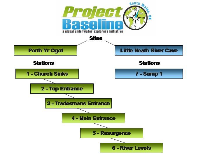
Project Baseline South Wales encompasses two caves in the Brecon Beacons area of South Wales, UK.
Both caves are popular with novice cavers and host good cave diving, leading to further dry cave passage beyond sumps.
Porth yr Ogof (PYO) and Little Neath River Cave (LNRC) are well known to be homes to albino trout and these are often spotted by divers in the sumps at various stages of colour transition.

Myself (Christine Grosart) and Dr Richard Walker are both members of GUE and the Cave Diving Group. We set up our Project Baseline South Wales in 2010, with our first data recordings in 2011


Project Baseline is structured by:

- Project Area
- Sites
- Stations


Project Area

[size=12pt]The project area is the region which covers the project sites. In this instance, it is the Brecon Beacons or more specifically, the Fforest Fawr area containing the rivers Mellte and Nedd Fechan.
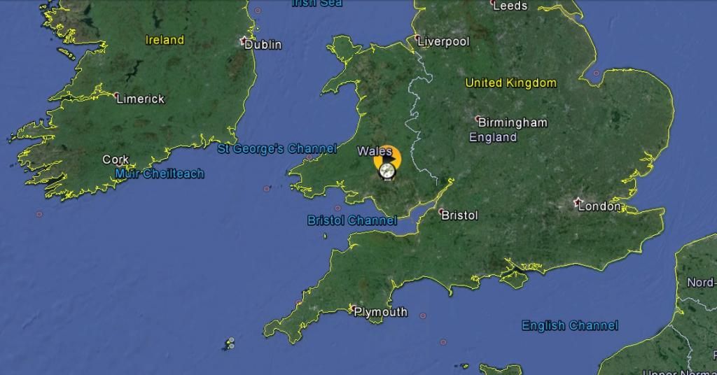


Global Location of Project Area
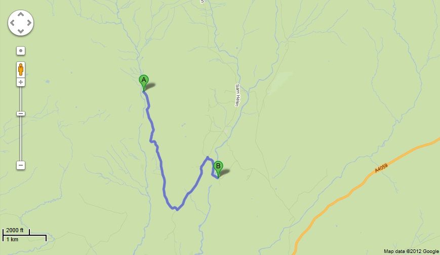

Map showing Project Baseline Sites - A Little Neath River Cave and B Porth yr Ogof
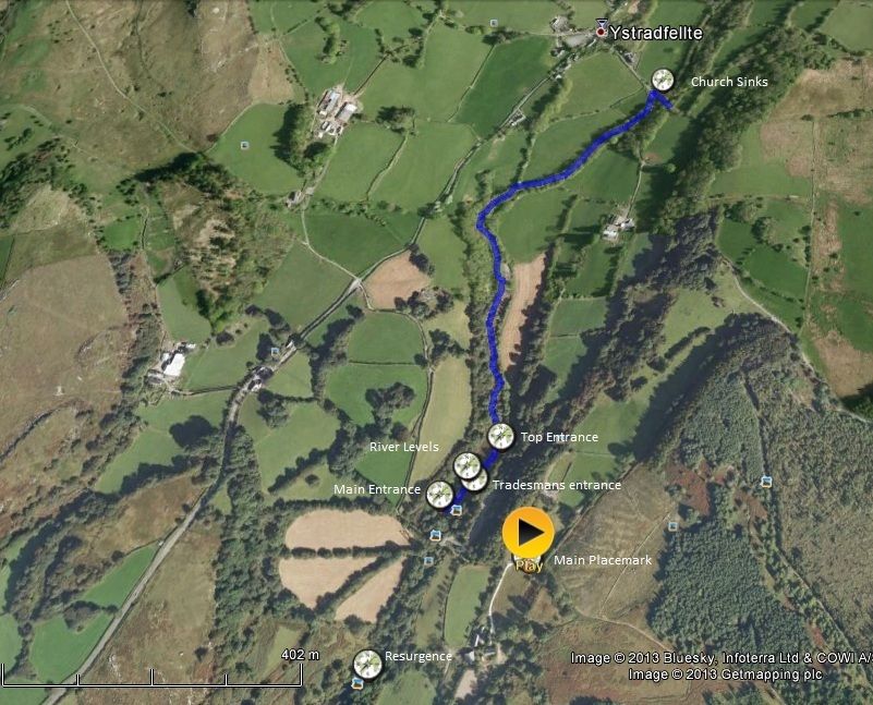

Google Earth aerial showing location of observation Stations at Porth yr Ogof

The structure of Project Baseline South Wales Caves:

What to do

Divers AND cavers can get involved with Project Baseline.
All we specify is that cave divers have suitable training for a fully overhead environment. Cavern training alone is not sufficient for the Diving station.

The following Data needs to be gathered at EACH STATION (where possible).
If you are unable to visit ALL of the stations in one trip, it does not matter.

Photograph at a FIXED Station
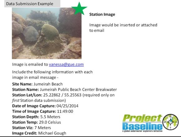


It is imperative that, attached to the photograph are:
- Site name
- Station name
- Station Lat/Long (ignore as this has already been done for you)
- Date of image capture
- Time of image capture
- Station depth (underwater only)
- Station Vizibility (Underwater only - see Vizibility measurement in the next section)
- Image credit

Photos are sometimes all the evidence you need...

UNDERWATER DATA COLLECTION

Station 3 (Tradesmans Entrance/Divers entrance) is the ONLY underwater Station in Project Baseline South Wales.

To take observations here, a secci disc will be installed at or near Cwmbran underwater junction.
This WILL NOT interfere with the passage or instruction of any other divers and should be left in situ. As with all scientific equipment, it should not be tampered with.
Conditions prevailing, this should be installed by Christmas.


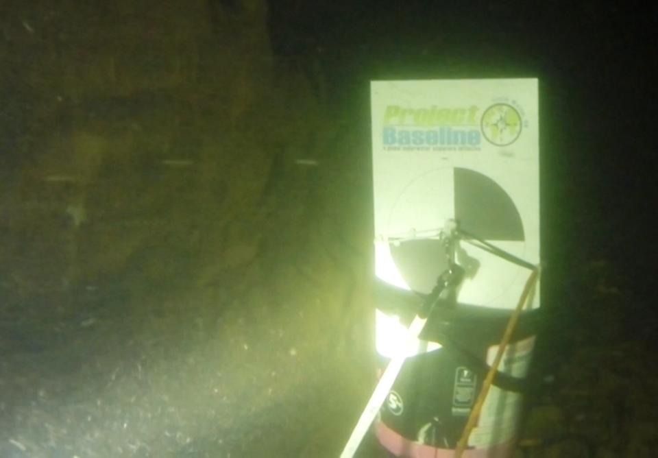
[size=8pt]Secci disc

Vizibility measurements should be made using the secci disc. Diving upstream, the diver should shine their torch ahead (hand held torches improve vizibility by up to 5 metres and should be used where possible) and stop when the secci disc becomes visible.
On the line will be some tags one metre apart. I will update the exact style of these tags so that they cannot be confused for anything else.
Vizibility should be measured by the number of tags between where the secci disc comes into view and the disc itself.

The underwater photograph should be of the cave surrounding Cwmbran Junction, facing upstream, with the junction in the shot. Do not dive past the junction before you take the photo as this will disturb the vizibility and make the data worthless.
There are various issues with the consistency of the quality of photographs underwater, as this slide shows:
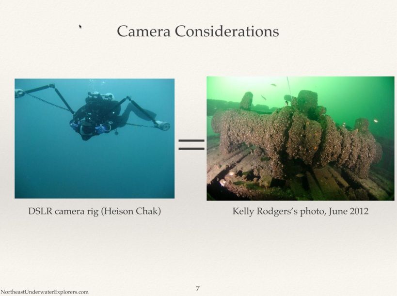


This is the same piece of wreckage, with various lighting techniques
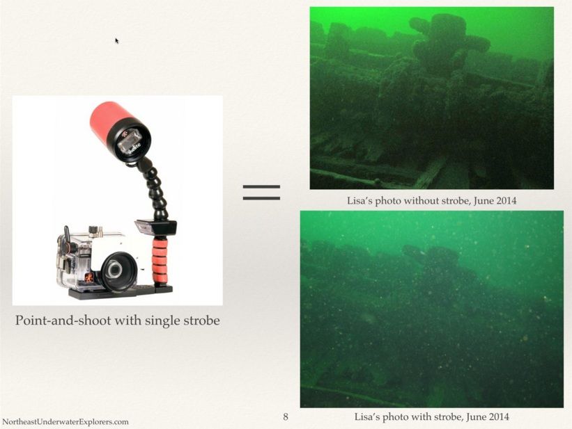


To be as consistent as possible, please turn helmet lights off if possible and use a static torch on the camera arms or on your wrist. Try and get as much 'spread' as possible and use wide angle where possible. The purpose is to show the passage in the area of Cwmbran junction, including any litter or trout in the vicinity (please do not import them into the photograph - you can document them later!)
[/size]

Before you dive, visit the data collection page and make a note of other data you can record:

http://projectbaselinewales.blogspot.co.uk/p/data-form.html

You can take data recordings such as:
- Water temperature
- Water levels (measure distance between water level and the top of the black 'step - or ledge' on the right as you enter Tradesmans
- Number of trout or other animals in the sump
- Fauna and flora outside the Tradesmans entrance
- Flow (High, medium, low)

On our next visit, we will be leaving some data sheets in the tourist office at PYO car park for divers to use and as a reminder of what data to collect.


Meanwhile, you can download a sheet for divers here:  https://drive.google.com/file/d/0BziDWmDikZ1GQ2ZPdUJ4UndSQWc/view?usp=sharing


ALL OTHER STATIONS

[size=12pt]That's where the cavers come in! Or the walkers..or anyone who likes to visit Porth yr Ogof and Little Neath River Cave.

The data collection remains the same. The photograph is imperative. Our Project Baseline South Wales Caves website has specific instructions of where to take your photo and what other measurements you can take.


I will shortly upload data sheets for cavers or anyone visiting the area who would like to take surface observations.

To find out more about Project Baseline South Wales, visit our site:
http://projectbaselinewales.blogspot.co.uk/p/test-page.html

For a less intense picture of Project Baseline South Wales, take a look at our video:

http://youtu.be/xuoUOB5pjMo

Date for your diaries: On Saturday 25th October I will be giving a talk on project Baseline at Harbour Lights, Portland Marina, Dorset 18:00-19:00.
This is in conjunction with another Project Baseline, the Portland Harbour Wreck Project.
All are welcome to come along and have a beer
  (y)

I hope you have found this post interesting and that, if you are able, you will support the project and it's long term goals to monitor and conserve the aquatic environment.

FAO Mods....
*I'm not sure where this should go - under conservation or cave science - but I'm happy for it to be moved as the Mods see fit and also, please could I request that this thread, as an ongoing project, could be considered as a sticky or something so it doesn't keep getting buried? Once sorted, this last text paragraph can be deleted. Thanks, Chris.*
 
What a fantastic project  :clap:

I love the way you have put the information and photo's together  ;)
 
Explanation of Vision, Mission, Purpose & Goals are clear    :bow:

Sorry I cannot help. I am not a cave diver.  :(

Best of luck.  Do hope that eventually you can make a difference to the area's and at least stop the degradation.  (y)
 

graham

New member
Extremely interesting project. Thank you for sharing.

I hope that your detailed data collection can overcome the problems that others have found with simple recording using fixed point photography, which has suffered from inconsistent use of film stock and/or CCD quality.

And one anecdote about 'environmental amnesia.

I was lucky enough to be very early into one particular, very pretty cave. A few months later and I was down there again with some other cavers on their first visit. they were blown away with the quality of the formations. I was disappointed. When I'd been there the first time, the columns were translucent and amazing. Now they were merely opalescent white and beautiful. Very few, very few indeed, people would have seen them as they originally were. No-one else would evenn have realised what had been lost to changes in air quality and dust in just a very short time.

And in answer to my critics elsewhere, that cave is still open, albeit fairly restricted, and we have just arranged for one young but very appreciative caver to get a trip down there. She will love it.
 

christine

Active member
Thank you for the positive responses  (y)

I have too drawn parallels with dry caves but I can't do everything  ;) My life isn't long enough!

The photography will be very difficult to achieve any kind of consistency and it is hard enough taking photos for scientific purposes in open water, never mind in the dark with sometimes strong currents as Porth often has.

I would like to say it is better than nothing, but actually poor quality or useless data is no better than nothing.

So, not surprisingly this project over here is still small...but there is no way I am going to turn away enthusiastic volunteers, some of which had been diving there for years and simply not considered actually looking a bit closer.

So, I've put this thread up in the hope that anyone heading over that way will enjoy being involved.

You don't HAVE to be a diver - the following locations all need data recording and photos taking on the surface as Porth is so seldom diveable:

Church Sinks
Top Entrance
Tradesmans (above water)
Main Entrance
River bed / water levels
Resurgence

If you visit our website, you'll be able to see how to take the topside photos and upload your observations.
If you see a squirrel in a tree above tradesman's entrance - record it!  ;)

An example here, for Church Sinks at Ystradfellte:
http://projectbaselinewales.blogspot.co.uk/p/church-sinks.html


christine

Active member
Hi Folks

Just giving you the heads up that there will be a (free, of course) online seminar about Project Baseline South Wales Caves on 23rd Feb (this coming Monday) at 7pm.
This is the link to the FB event: https://www.facebook.com/events/738683389563780/?ref_dashboard_filter=upcoming

If you don't use Face-ache, please PM me for your invitation.

This will be of interest to anyone who walks or caves near or at Porth yr Ogof and Little Neath River Cave. You don't have to be a diver!
The seminar will go over the type of data we need and how to collect it.
The online seminar will last about an hour with questions at the end.

PB HQ are hoping to set up a GoToMeeting platform for us - so watch this space for how to join. Meanwhile, please visit the Facebook page or PM me.

Best wishes
Christine
 

Bottlebank

New member
rhychydwr1 said:
Les W said:
rhychydwr1 said:
Where and what is UTC?

UTC is Coordinated Universal Time (UK equivalent is GMT)
http://en.wikipedia.org/wiki/Coordinated_Universal_Time

Clear as mud

That's the trouble with letting very intelligent people have their own way sometimes. I'd have called it CUT.

On the other hand since everyone understands GMT I wouldn't have bothered with it in the first place.

As for the Google hangout gotomeeting platform circle bit I'm comfortable in the knowledge that those who need these things in life probably enjoy and understand them, so I won't bother asking what they are.

One question though. Is an online seminar a bit like a pre video recorder TV programme, i.e. if you miss it you've missed it? If so why not just make the video and stick it on Youtube?

:eek:
 

christine

Active member
Bottlebank. If you don't want to attend, you are not obliged to.

I would appreciate a little more 'grace' with regard to what we are doing here.

No, it will not be broadcast on youtube. We are looking for dedicated volunteers, not armchair voyeurs.


christine

Active member
Information for the Project Baseline South Wales Caves Online Seminar:
Here is the information you need to join the Project Baseline South Wales Caves Online Seminar on Monday 23rd February 2015 at 19:00 GMT UK time.
We will no longer be using Google Hangout as the attendance is likely to exceed the limit of 10 people. So please sign up to GoToMeeting in plenty of time.
We are delighted to kick off with an introduction from Vanessa Belz, as I would very much like you all to 'meet' her! She is the backbone of Project Baseline and she will be available afterwards for any questions. After introductions, she will hand the seminar over to me so that I can explain the details of the South Wales Caves project.
If you walk, cave or dive at Porth yr Ogof or Little Neath River Cave, you may enjoy contributing to the project. All you need is a camera (or cameraphone!) and a notepad and pen.

PB South Wales Online Seminar
Mon, Feb 23, 19:00 GMT or 1:00 PM Pacific Standard Time
Please join my meeting from your computer, tablet or smartphone.
https://global.gotomeeting.com/join/895208061
You can also dial in using your phone.
United States (Long distance): +1 (571) 317-3112
Access Code: 895-208-061
More phone numbers: https://global.gotomeeting.com/895208061/numbersdisplay.html
 

Bottlebank

New member
christine said:
Bottlebank. If you don't want to attend, you are not obliged to.

I would appreciate a little more 'grace' with regard to what we are doing here.

No, it will not be broadcast on youtube. We are looking for dedicated volunteers, not armchair voyeurs.

Err, ok, that was a lot clearer :)

So what's your seminar about? And before you ask I've read the facebook page and you sort of mention it applies to the UK as a whole, which is what got me interested. What it doesn't do is explain what it is - at least not in simple terms for armchair cavers, sorry, voyeurs, like me?
 

christine

Active member
There is a very long and well constructed post right at the start of this thread which explains everything about Project Baseline in a lot of detail.
The seminar is purely to help volunteers who are already engaged - or who would like to be - with how to take data readings, take photos correctly etc. The information is already out there (see OP) but it was felt that a support seminar would make things clearer, as people are not always keen on reading lots of information on the internet - as you have demonstrated.
It is very well explained in quite a lot of places.


graham

New member
Bottlebank said:
That's the trouble with letting very intelligent people have their own way sometimes. I'd have called it CUT.

On the other hand since everyone understands GMT I wouldn't have bothered with it in the first place.

Ahem

The official abbreviation for Coordinated Universal Time is UTC. This abbreviation arose from a desire by the International Telecommunication Union and the International Astronomical Union to use the same abbreviation in all languages. English speakers originally proposed CUT (for "coordinated universal time"), while French speakers proposed TUC (for "temps universel coordonn?"). The compromise that emerged was UTC, which conforms to the pattern for the abbreviations of the variants of Universal Time (UT0, UT1, UT2, UT1R, etc.).  :sneaky:
 

christine

Active member
This is the Facebook page event description:

'An online seminar which will explain all about Project Baseline: South Wales, UK and PB as a whole. It will explain in detail how to make data recordings, take 'stake in the sand' photos and how to record data and use the public query interface.
Anyone who dives at Porth yr Ogof or LNRC are particularly welcome.
The platform will be GoTo Meeting. Invitations will be set up to those who click 'Going'.'

If you could tell me which part you would like me to explain, I'll do all I can to help.
 

Bottlebank

New member
Sorry, I read your post on Tapatalk and it's hard to tell what is a new thread and what isn't, hadn't realised it was part of a longer discussion, so all I saw was the facebook page which I couldn't make sense of in it's own right. I'm beginning to seriously dislike Tapatalk!

Reading it properly on a PC now it makes more sense.

I'm sure all your volunteers will understand gotomeeting's, hangouts and circles.

I'll bow out, although I still think UTC would make more sense if it was CUT :)


christine

Active member
Glad it's looking clearer to you Bottlebank  :)
I don't use Tapatalk either......

I'm trying to keep this thread as an 'alternative' for those who prefer it to Faceache etc.
Really just for info and updates on the project.

Chris
 

christine

Active member
W hope some of you will be joining us at 7pm for the Project Baseline South Wales Caves online seminar.

Please note this updated link - the meeting is 7pm UK time.  (11am PST)

https://global.gotomeeting.com/join...good time before the meeting. See you there!
 

ah147

New member
Very good presentation/meeting it was too!

Would only add a few minutes to any trip and anyone can do it.

The "conservation education" that many people hark about, this project would go a long way to helping that.


Sent from my iPhone using Tapatalk
 

christine

Active member
Just a quick update on the underwater visibility station.


A new Secchi disc has been installed just upstream of Cwmbran underwater junction. This is for visiting divers to have a go at taking visibility readings when they dive at Porth.
Cwmbran junction is 28 metres upstream from the Tradesman's Entrance.

The Secchi disc will not interfere with anyone's dive or any courses which go on in the cave.
Please extend the project the courtesy of leaving the disc alone if you are not taking readings from it.
It is currently used as a belay but I will probably change this so that the disc is independent of the line.

If you would like to contribute to the project by adding to our observations, here are the instructions for taking readings of:
-Visibility
-Temperature
-Depth
-Flora/Fauna
-Flow
-Standard photo/screen grab
-Water levels


Visibility:

Station 3A is the underwater station and a Secchi disc is located just upstream of Cwmbran junction (the first line junction you come to) at approximately 3m depth and 28m from dive base at Tradesman’s entrance.

Ensure you are the first diver in the water.

To complete a set of observations at Station 3A:

- Take a depth reading at the secchi disc
- Take a water temperature reading at the secchi disc
- Clip a tape measure or knotted/marked line with distance markers to the loop on the secchi disc and reverse away until only one colour is visible. Wait for any silt/disturbed particles to disappear before taking the measurement.
- Make a note of the type of light used (hand held or helmet mounted - please do not use both together) and make a note of the type of depth/temperature instrument.
- Take a photo or screen grab from video of Cwmbran junction, facing upstream.
- Make a note of any trout, bullheads, litter etc.

Flow:
Please record the flow:
Low - Barely any effort required to fin normally upstream
Medium - Some effort required to fin upstream
High - Quite a lot of effort required and 'pull and glide' techniques need to be used.

Low/Medium or Medium/High can also be used.

Standard Photo/Screen Grab:

Dive upstream for a few metres and stop at Cwmbran junction, which is an obvious junction in the line, where the 3rd branch goes steeply up to the left into branches and the often blocked Cwmbran entrance.
At the moment, divers need to take their own tape measures but we are hatching a plan to make this even easier.

Please send one photo of the cave passage in the vicinity of the secchi disc.
Label your photo with the following information:
Date photo taken
Time photo taken (HH/MM) 24 hour clock
Name of photographer

We cannot accept photo submissions without this information. Please make your jpegs 1-5MB.

Water Levels:
Divers will be familiar with the flat black ledge on the right as they look into the Tradesman's sump.
As you have a tape measure, please measure the distance between the top of the black ledge and the water.

Once you have all your data, please fill out the data capture form here:
http://projectbaselinewales.blogspot.co.uk/p/data-form.html

Don't forget to tell us what type of torches you used and where they were mounted i.e head/hand. Please do NOT take visibility measurements using both - please switch off one so that we get a truer reading. Please also tell us what type of depth/temperature instrument you are using i.e Uwatec D-timer or Suunto Vyper, liquivision xen etc.

If you have any queries, don't hesitate to contact me via here or email me via the contacts page on the Project Baseline webpages.
Difficulties we are having are:

- Getting people to take temperature readings in the water
- Getting a 'standard' photo rather than a holiday snap  :confused:
- Getting correct data attached to photos ie Date of photo, time of photo and name of photographer.
- Getting data from Church sinks at Ystradfellte and also Top Entrance.

But the project is making ground.
We have a steady stream of data coming in now but please take the time to fill in as many fields as possible and be as accurate as you can.

The Little Neath River Cave station (7) has yielded some interesting reports this year. The diesel smell seems to have subsided this last month - but only frequent data submissions will help with tracking this problem.
Bullheads and trout have been reported in sump 1 alive and well  :beer:
 
Top