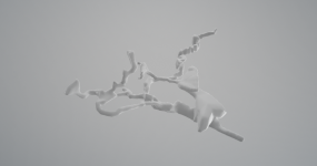
Ariel Cave in 3D

John_Smith

New member
Hello all,

Thought that I would get around to showing off my hard work from a while back.

Here is a 3D model of Ariel Cave on Portland https://sketchfab.com/3d-models/ariel-cave-697f4d3389ed4985928de41ad9a16aee

I used QGIS 3.10 for the main GIS work (https://www.qgis.org/en/site/) and the Qgis2threejs Plugin for the 3D visualisation (https://qgis2threejs.readthedocs.io/en/docs/).

Essentially how I created this was using the following data:
1 LIDAR digital surface data (https://data.gov.uk/dataset/0ab507af-cd91-40cb-8524-3efafc267211/lidar-composite-dsm-50cm or https://data.gov.uk/dataset/80c522cc-e0bf-4466-8409-57a04c456197/lidar-composite-dsm-1m)
2 Ariel Cave survey (http://staticweb.mcra.org.uk/surveys/Ariel.pdf)
3 Google satellite imagery (XYZ tiles: http://www.google.cn/maps/vt?lyrs=s@189&gl=cn&x={x}&y={y}&z={z} or https://mt1.google.com/vt/lyrs=s&x={x}&y={y}&z={z})

And the following basic steps:
1 Georeference the Ariel Cave survey map
2 Digitise the passages and rifts
3 Using the survey, assign Z values for the passages and rifts based on altitude in metres
4 Load the data into Qgis2threejs and use the Z values from the LIDAR and digitised shapefiles to display height and drape the imagery over the LIDAR data

If more altitudes were available then tools like v.drape can be used within QGIS (https://grass.osgeo.org/grass76/manuals/v.drape.html), but this cave is essentially flat anyway...!

If anyone wants to know any more details, let me know and I can help you out with anything GIS related.

Enjoy!
 

John_Smith

New member
tim.rose2 said:
Excellent effort that be!  Would be good to see the same for the Grove Caves (hint hint).

I have been toying with it and I have a plan! Just need free time to look at it properly. Hopefully over Christmas.

Mr Dinwiddy said:
That is fantastic. How long did it take to process the raw survey data into that?

Not long really, though I do this sort of thing for a job so I know what I'm doing. I'd say the whole thing only took about a few hours with some trial and error. The most time consuming bit was georeferencing the survey. The map extent on the survey only shows part of the coordinates so I was confused when the survey appeared out at sea at first...
 

Tommy

Active member
Good stuff John, that looks fantastic. How did you go about converting the survey into something volumetric?

I ask because a year ago or so I found a simple if clunky method of converting Survex files into CAD data for 3D printing or further manipulation.

It may be of use to you or someone else searching the forum down the line.

Code:
import Survex file (.3d) to Therion Loch
export from Loch as .vtk

import to Paraview
export as .x3d

import to Meshlab
export as .stl or .obj

import to Autodesk Meshmixer for tidying up and artistic improvements.

Warning - Stray splays can end up adding some extra lumps that aren't really there. It isn't foolproof but it works fairly well.

P8 Attached.
 

Attachments

  • P8 Meshmixer.png
    P8 Meshmixer.png
    594.8 KB · Views: 283

John_Smith

New member
Topimo said:
Good stuff John, that looks fantastic. How did you go about converting the survey into something volumetric?

I ask because a year ago or so I found a simple if clunky method of converting Survex files into CAD data for 3D printing or further manipulation.

It may be of use to you or someone else searching the forum down the line.

Code:
import Survex file (.3d) to Therion Loch
export from Loch as .vtk

import to Paraview
export as .x3d

import to Meshlab
export as .stl or .obj

import to Autodesk Meshmixer for tidying up and artistic improvements.

Warning - Stray splays can end up adding some extra lumps that aren't really there. It isn't foolproof but it works fairly well.

P8 Attached.

Thanks for sharing! I have never used Survex files, are they just a type of 3D file or are they linked to somewhere in space? The advantage with doing this stuff in GIS is that every point in the cave is linked to a specific real world XYZ position. I remember reading somewhere that a QGIS plugin was created that can read Survex files... I'll have to get researching (unless I imagined it!).

That is one limitation of my first quick try, there is no realistic 3D representation of the cave passage. What you see is a standard size I just gave the passages for visualisation purposes. This is something that I figured out later, but if I had measurements with widths and heights I can tell QGIS2threejs to visualise the passage sections as cubes with these height and width dimensions. So you can see that it wouldn't be a true representation of width and height, as this would be done in small 3D blocky sections along a passage.

The proper way that I am going to do it is:

1 Georeference the cave survey
2 Digitise the passages as a polyline shapefile (adding width and height attributes to each section where there is a change in height or width)
3 Digitise points of altitude in the cave as a point shapefile with the altitude as a Z value field
4 Interpolate a surface from the altitude point shapefile
5 Use v.drape to drape the cave passage shapefile onto the interpolated surface to give each section a 3D height value
6 Display in QGIS2threejs and assign each section the original height and width dimensions and display as a cube

The only problem is that height and width are displayed relative to the centre of a polyline in 3D, so the altitude measurements need to be in the centre of the cave passage which can be corrected for.

Tim has kindly shared his Grove Cliff Caves survey data with me which I hope to recreate using this method in 3D. But it will take some figuring out!

Cheers
 

John_Smith

New member
John_Smith said:
I remember reading somewhere that a QGIS plugin was created that can read Survex files... I'll have to get researching (unless I imagined it!).

Found it!

https://github.com/patrickbwarren/qgis-survex-import

Comes with a nice handy guide too.
 

Tommy

Active member
Yep survex files (.svx for the script and data, .3d for a view only export) are the standard cave surveying file format for passage centre lines and splays or LRUDs (left right up down).

At their most basic the data points in a file are all relative to their own coordinate system, however it is trivial to provide geographic data to link the data to reality, there are some impressive efforts available for download from the BCA cave registry showing hundreds of caves in various regions all linked together in a file structure with master files and geo references etc.

Have a skim of the survex documentation and have a play with some of the downloadable data from the registry - .svx files. You'll be up and running in no time.

I haven't played with Qgis survex integration, though I'm sure others on the forum may be able to help.

Survex - data and skeletons
Therion - producing final plan and elevation surveys for publication
Qgis with the above - display the data alongside all the other geo data you could dream of
Or just load surveys into Google earth for similar but less technophilic results.
 

Tommy

Active member
I'm happy to do the conversion process for you if it helps get a proof of concept done as I have been playing around with paraview a bit recently for another project and I still have some familiarity with meshmixer on the cleanup side.
 
Top