Glebe Mine to close

zippy

Member
As a few of you are aware, earlier this year we completed a short film.  Entitled "From Ore to Orchids", it looks at how the Peak District's industrial past & present have influenced the Peak District landscape, and how it continues to do so - with a strong emphasis on mining/mineral extraction.

The relevance here, is that it features quite a bit of footage of Glebe's activities on Longstone Edge, an interview with their main geologist, and an interview with their counterparts who were oposing the development of Tearsall quarry.

(The blatant plug is at http://winstercavers.org.uk/film_FromOreToOrchids.aspx)

If it's of interest to people, we'd be happy to organise a public showing of the film at a suitable establishment in the Peak (such as the Miners Standard in Winster!) free to anyone who wants to come along, but we'd use it as an opportunity to rattle a tin for DCRO...

Your thoughts?

Z
 

nickwilliams

Well-known member
Good plan. If you wanted to show it somewhere closer to the Glebe operation than Winster then I'm sure we could get a date at the village hall in Litton or the Nightingale Centre in Hucklow.

Nick.
 

John B

New member
Just read the posts expressing concern that stopping pumping from Watergrove will affect Carlswark. This is true, but all that it will mean as far as I can work out is that the Merlin Streamway may only dry up in drought rather than in most summers.

When Watergrove Sough is flowing, it just means that the Fairburn Shaft is full up to sough level. When the pumps reduce it below the sough (150ft down, or about 690ft OD) the sough stops. It may still stop flowing in summer, but not as often. I think much of the water in the Merlin Streamway is leakage from Watergrove Sough. It is certainly a misfit stream as there are stalactites in the sumps.

The reversal of flow in the Big Dig Series (where the stream flows down to the Bedpan Sump instead of all the water going out through Big Dig) is caused by the existence of Glebe Mine, which punctured the Bedpan Sump at its lowest point. This meant that instead of the whole area from Big Dig to the Bedpan being flooded, with water overflowing through Big Dig, it all flows down-dip to join water that comes in from the west, and goes out through Moorwood Sough. There is unlikely to be any change to this.
 

AndyF

New member
It will be interesting to see if any water starts flowing in Rubble Rift/Hangover/Paracteum...
 

MarkC

Member
John B said:
water that comes in from the west, and goes out through Moorwood Sough.

John,

Where do you think this west water comes from?  Has it ever been dye traced from any of the swallets below Eyam Edge?  And has the streamway in Streaks/Nickergrove ever been dye traced to the Merlin Streamway?  If not then perhaps  this western water originates from the streamway in Streaks/Nickergrove instead.  According to the survey the Nickergrove Streamway seems to be heading north, down dip toward White Rake.  In effect the water would have gone down dip on the western side of Cucklet Delph and then back up dip to the lower streamway on the eastern side of the Delph.

Sump 8 in the Merlin Streamway gets very close to Jumber Brook and the OS first edition shows the Jumber Brook sinking half way down Cucklet Delph.  The most obvious source of the water in the Merlin Sreamway could therefore just be from the bed of Jumber Brook perhaps?  :unsure:

Mark
 

John B

New member
Even when Merlin, the Jumber Brook, and everything else in the Dale are dry, there is still a large outflow from the Boil-up into Glebe and the sough. It was followed for about 600ft by divers in the 1980s, but it is hard to get there now due to collapse. When everything is flowing, there are small inputs to the Lower Streamway which may or may not come from the Jumber. There can be a stream in Nickergrove when Merlin is dry, so it goes to the Boil-up (there is nowhere else it could go). Under these conditions there is not enough water anywhere to account for the flow from the Boil-up, other than meteoric water from the large catchment to the west. I can assure you that there is no thermal input to it from depth as it is bloody cold, though not as cold as Watergrove!
 

MarkC

Member
Sounds like getting access to the Nickergrove Streamway for divers to have a go at the downstream sump is the only realistic way of finding out whats towards the west.

Chesterfield CC has started doing some renovation to the Timbered Shaft in Nickergrove to hopefully get back into the big streamway chamber.  However this is very much a work in progress and it will certainly need a lot more work to make it diver friendly (i.e. to get their equipment safely to the streamway).  We were going to scaff the shaft to reinforce the existing timber and then pack in more timber around the new frame, however the oil drums have also sunk down at the bottom too.  We could probably do with some of that plastic pipe for a final solution to the problem.  Anyone got any ideas?

I've taken some pictures of the timbered shaft and the beginning of the passage at the bottom, which I can post if somebody could help me with this.

Mark
 

martinb

Member
Ask AndyF if there is any pipe left from the Flower Pot renovations?

Could be interesting getting it to dig site though?  :-\

Martin
 

JonP

Well-known member
at the bottom of the timbered shaft is a timbered level speaking to John about it it seemd to make more sense to drive a new sheft agains the left wall as you walk into the clay chamber thus eliminating most of the timbered level. plus a solid wall is a nice feature. I'd be willing to give you a hand when I can although the place had to be pumped due to the air getting crap so this may be another issue.

Im sure someone on here will know if theres any more of that blue pipe available. I know Dan has used a few lengths for Gateham Swallet.
 

MarkC

Member
JonP said:
at the bottom of the timbered shaft is a timbered level speaking to John about it it seemd to make more sense to drive a new sheft agains the left wall as you walk into the clay chamber thus eliminating most of the timbered level. plus a solid wall is a nice feature.

Thats a lot of clay to dig through, to remove a section of timbered passage thats only 2-3m long.  From the photos I have taken at the bottom of the shaft under the oil drums the level is open, lined with metal sheets, and has a solid wall on one side.  There is a small failure of one of the timbers on one side, but its not blocking the way completely and so could be easily repaired and reinforced with steel.  The 'letter box' john told me about can be seen beyond,and from there on the passage is in rock.

The condition of the timbered shaft is also better then you would think given the length of time it has been there, and could be easily be relined.  We were originally planning on using scaff poles and with metal sheets/new timbers behind to hold back the clay, however using the pipe may be a better solution.  We would have to cut the pipe in half to get it down there I guess, and then re-bolt it back together in the shaft.  However I hear its quite heavy stuff (even when cut in half), which may cause a problem?

Mark
 

Rob

Well-known member
Yes, that pipe is very heavy and difficult to manouver, and i think it would still be if in half. Also it's very unflexible in it's end design.

Scaffold and boarding works in all other situations...  (y)
 

martinb

Member
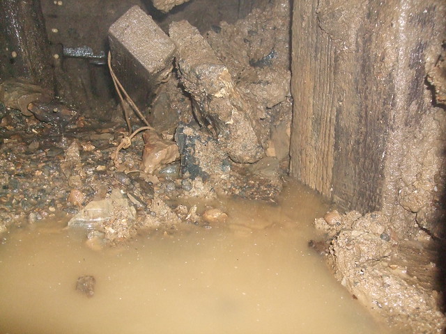
Picture of bottom of Clay Chamber Shaft taken on 11/11/10. Looking towards Stream Chamber.

Wall failure on right.

5199114573_d12b61a45a_z.jpg
 

Stoneman

New member
To answer the question " have the swallets below Eyam Edge every been die tested" YES. Waterfall Swallet was die tested by BSA/TPU. The tests showed the waters resurged at the Moorwood Sough. Die was also detected in Glebe Mine. Nothing was found in the standing water in Carlswark. But at that time there was no active streamways in the then known system, viz old and new system.
 
Top