

You are using an out of date browser. It may not display this or other websites correctly.
You should upgrade or use an alternative browser.
You should upgrade or use an alternative browser.
Glebe Mine to close
- Thread starter martinb
- Start date
AndyF
New member
Possibly ... it could have both positive and negative consequences.
all depends what, if any, pumping is being done.
Big dig series in Carlswark used to be a phreatic riser flowing outwards. The mining intercepted that flow and reversed it. That could now return to its normal route and flood that end of Carlswark.
On the other hand, it may allow access to previously off-limits areas, allowing exploration off up towards the sinks.
John B will know the effects for sure...
Speleokitty
New member
Glebe Mine closed decades ago.
Glebe Mines Ltd is the company that operates Watersaw mine, Cavendish Mill etc. It will not affect Carlswark.
Its a real shame to see the ending of mining in the peak and a lot of people depend on it for employment. On the other hand it will probably prevent the destruction of more old mine workings.
Kitty
Mark
Well-known member
martinb said:Reported in the Derbyshire Times - Thurs 4th Nov.
".........failed to attract investors, will close its doors with the loss of 65 jobs......."
Does this have any impact on local caves?
Its not just the jobs at Glebe Mines, it will affect loads more local companies, lorry drivers, and tributors who bring fluorspar from their own sites. this on top of the closure of the quarries at Stoney Middleton is another kick in the teeth for the locals
martinb said:Just to clarify, it is Cavendish Mill that is closing.
Glebe Mines is the name of the company who took over Cavendish Mill, it is also the name of the company that started it in the first place.
zippy
Member
...and it should be noted that, as I understand it (and please correct me if this is in any wrong):
Glebe are basically planning a 2 year withdrawal/clear up - so it's not an overnight closure.
I believe they are still actively looking for a buyer, but as yet no one has come forth. Ineos Fluor have stated that they will continue to buy fluorspar if its on offer, but will not commit to anything substantial enough to warrant the investment required to open Tearsall & Milldam, both of which would be required to provide the right blend of ore grades.
They do pump water from high up the dale (watersaw mine?) to supply Cavendish Mill - if those pumps stop, then yes, we can expect to see some of the hyrdology revert. Ideas mooted are that the Merlin sump may not dry up in winter, and the the springs at the top of the dale may start to flow again....
There are also big questions about some of the land restorations, as much of the plans are based around using overburden from current operations.
Yes, whilst in some respects it may offer a reprieve for certain areas of the Peak, it also represents a major loss of jobs for the area - and lets face it, there ain't much industry in the Peak that isn't tourism based!
Z.
Speleokitty
New member
[gmod]Fixed quoting[/gmod]zippy said:They do pump water from high up the dale (watersaw mine?) to supply Cavendish Mill
The water for Cavendish Mill comes from Watergrove Mine
Kitty
nickwilliams
Well-known member
I have it from a reliable source that the pumps in Watergrove have been switched off for the last time today. I'm told the pumps move about 160 cubic metres per hour so this has resulted in an increase in the sough tail outflow. This looks like being about 10% today, although how much of that is due to today's appalling weather is difficult to say. There is likely to be a commensurate increase in water levels in Carlswark.
I've also been asked to point out that the security on all the Glebe mines will remain in place for the foreseeable future. As has already been mentioned, Glebe will be entering a clear up phase expected to last for some months, and security will be maintained at least until all their equipment has been recovered.
It is likely that the pumps will be run for short periods during the clear up but there is no schedule for this nor is there any mechanism for giving a warning to anyone underground that the water levels may fluctuate. Please take responsibility for your own safety accordingly.
Nick.
Pete K
Well-known member
So, I'm aware that the water flow in the back area of Carlswark has been reversed due to the pumping of water from the local mines and is likely to return to its original flow state at some point (e.g. flowing from Shags Sump and Bedpan Sump out of Big Dig and down towards Rift Sump).
Having never seen or experienced this myself I don't know how much this will affect caving in that area.
Do the passages from Bedpan Sump to Dynamite Passage still go freely or will parts become permanently sumped?
I guess the 'round trip' of the small loop via the duck (Cockle) may well become a weather dependant trip?
What about the Resurgance entrance? Will that revert to being a true resurgance or continue to be open passage to the climb up to Oyster Chamber?
I use the system a lot with young novices and wouldbe cavers/trainee instructors and I'm hoping not to lose a useful venue (or big parts of).
al
Member
Pete K said:I guess the 'round trip' of the small loop via the duck (Cockle) may well become a weather dependant trip?
This already happens. I was in there a few years back at Xmas and, at the T junction beyond the conveyor belting, I met a large stream flowing from Big Dig and down Dynamite Passage. Both Big Dig and Dynamite Passage were just about sumped, but it was possible to get around the crawl through the duck to Stalactite Passage where the water was thundering out of the bottom end of Dynamite Passage in an impressive fashion. The Rift Sump below Aladdin's Crawl was backed up to the top of the climb down, and the climb down from Eyam Passage to the lower entrance was likewise filled.
Chocolate fireguard
Active member
Yes I saw Stalactite Passage like that about 10 years ago and it made a good trip. The bottom of some of the roof pendants were under water so you had to weave around them. Coming back against the flow was quite hard work. Does the water ever back up in Dynamite Passage and flow through the old sump?
Rob
Well-known member
Much lower. The only reference i can find is 465' O.D.AndyF said:Seems likely that Moorwood Sough may limit the potential rise in water level, but I'm not sure what altitude that runs at...
For comparison, Watergrove Sough is ~660' and Carlswark Resurgence is ~570'
SamT
Moderator
pumps or no pumps - its gonna be wet tomorrow, just driven back through the peaks and the amount of standing water on the roads is incredible.
Could have done with a snorkel intake on the astra for the green at baslow which was under about 18 inches of water.
Guess there are a lot of leaves in a lot of drains at the mo
Could have done with a snorkel intake on the astra for the green at baslow which was under about 18 inches of water.
Guess there are a lot of leaves in a lot of drains at the mo
martinb
Member
Rob said:Much lower. The only reference i can find is 465' O.D.AndyF said:Seems likely that Moorwood Sough may limit the potential rise in water level, but I'm not sure what altitude that runs at...
For comparison, Watergrove Sough is ~660' and Carlswark Resurgence is ~570'
Is that the Tail of Watergrove Sough at 660'?
Didn't think there was a 90' difference between that and Carlswark Resurgence! :blink:
Me and couple of mates were going to have a dig at the branch in Watergrove - but if there's going to be a lot more water coming down, I don't think we'll bother!
Mind you - if there's a LOT more water it may pop the choke up there!
Rob
Well-known member
Yes it does flow, and maintains a steady elevation throughout as there are very few sections of interuption in the water. Mostly like this all the way from Stoney to Eyam...AndyF said:I've never seen the Moorwood tail... I assume it still "flows". I think it was maintained when Glebe was still active.
Yes, AFAIK...martinb said:Is that the Tail of Watergrove Sough at 660'?
I don't think a couple extra cubes a minute will make much difference, i'd imagine it'd be measured in cubes per second today!martinb said:Me and couple of mates were going to have a dig at the branch in Watergrove - but if there's going to be a lot more water coming down, I don't think we'll bother!
Mind you - if there's a LOT more water it may pop the choke up there!
martinb
Member
Rob said:Yes it does flow, and maintains a steady elevation throughout as there are very few sections of interuption in the water. Mostly like this all the way from Stoney to Eyam...AndyF said:I've never seen the Moorwood tail... I assume it still "flows". I think it was maintained when Glebe was still active.
Yes, AFAIK...martinb said:Is that the Tail of Watergrove Sough at 660'?
I don't think a couple extra cubes a minute will make much difference, i'd imagine it'd be measured in cubes per second today!martinb said:Me and couple of mates were going to have a dig at the branch in Watergrove - but if there's going to be a lot more water coming down, I don't think we'll bother!
Mind you - if there's a LOT more water it may pop the choke up there!
Is that person standing up in the sough or kneeling?
Good thing I've just purchased a canoe!
Rob
Well-known member
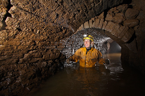
Standing, it's mostely quite a sizable passage, as shown in this photo:martinb said:Is that person standing up in the sough or kneeling?
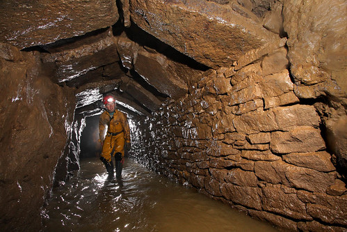
However some bits are a bit smaller...:
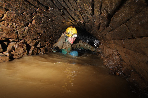
As for access, pretty sure it's not allowed. No idea who took these photos or who's in them...
