• CSCC Newsletter - May 2024

    Available now. Includes details of upcoming CSCC Annual General Meeting 10th May 2024

    Click here for more info

Churn Milk Shakehole/ cave (penyghent)

newcastlecaver

New member
Does anyone know anything about this beyond what is written in Northern caves? A quick google search doesn't reveal anything new? I walked past last weekend and although I didn't have a detailed look I got the impression that most the water coming off fountains fell on the way to Brants gill must go under here or near? Given the proximity to Dale head pot (deep) is there potential?

any recent digs?

any access issues?

hmmmmmm
 

dunc

New member
is there potential?
Isn't there always potential...??

A stream sinking at a very roughly similar altitude to Dale Head, must be potential, somewhere, although from odds and ends I vaguely recall reading it sounds like it would involve considerable effort!

I got the impression that most the water coming off fountains fell on the way to Brants gill must go under here or near
If the known FF-Master Cave continues in a similar direction(/line) en-route to Brants Gill it wouldn't be too far off passing under it.
 

braveduck

Active member
No recent digs in Churn Milk.The logistics would be tremendus.
You would have to find one solid wall, then shaft sink for at least 100ft though boulders.
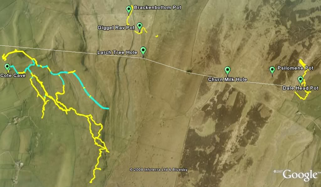
This is on a major fault.
If you cross the wall along the footpath to Phenyghent,so you are on the Ribblesdale side of the ridge,
you will find a shakehole just as big as Churn Milk with no name(Google Earth it).
This MAY be a slightly better bet for a twenty year dig, same fault,this has never been dug to my knowlege.
Better still Larch Tree Hole dug both by CPC and BPC has a draft same fault.Job never finished.
Much easier digging ,lovely Slikensides, fault narrower here so digging possable.
These three holes all line up and also line up with Sulber Nick on the other side of Ribblesdale.
Going the other way towards Fountains Fell allowing for a slight bend in the fault I recon the massive shakehole that was Coat's Cavern
is also on the same fault.This is undoughtedly the conduit that carries the Fountains Fell water to Brants Gill and Douk Gill in Ribblesdale.
Look in vain for the fault on the Geological Map of Phenyghent.Once talked to the two Geologists who had just remapped this area,and told them about the Slikensides in Larch Tree Hole and that they had missed a vey big fault off their map.They were less than pleased!
A real case of professonals and amatuers not mixing.
 
PenyghentSouth.jpg


BraveDuck's fault is marked as a white line. Dale Head Pot doesn't fit very well. Maybe the main fault swings further south and Dale Head is on a subsidiary parallel fault.

From Larch Tree Hole westwards, the signs of the fault are clearly visible on Google Earth, and if you extend further west it does indeed line up fairly well with Sulber Nick.
 

braveduck

Active member
Thanks for that Cave Mapper brilliant!
I now know Brackenbottom Pot is NOT on the fault, thank goodness.
At some point if the FF water follows this fault which it must really,it has to turn North to get to
Brants Gill and Douk Gill.
Also  shows the possibillity that Cote Gill is an overflow system to the FF water system when all other passeges
are full.
Note the unamed very large shakehole on the line between Larch Tree and Churn Milk.
Worth a visit, spent several hours smoke testing for a draft ,but found non.Not that day anyway!
Have you tried lineing it up with Coat's Cavern on FF.
Keep up the good work Cave Mapper.
 

Scoff

New member
For completeness. The Big Shakehole referred to by Braveduck received attention from fellow club diggers in 1983/ 84 (with technical assistance from the NCC). It was likened to 'ants in a sugar bowl' - the whole bottom of the shake being large blocks - the nearest bedrock being in the west side of the shake some 6 - 10m above the bttom of the hole. Even when a boulder was 'dealt with' the rest just rolled into its place...

With regard to Churn Milk, it was said back then that the White Rose has dug down into the hole to the South of the track some 15 - 20m through hanging death boulders until they had frightened themselves silly...

Also of interest to theorists is, of course, the 330 degree fault/ joint which has a strong influence on Penyghent (e.g. the main rift in Penyghent Pot - see the ULSA Explorations Journal cave/ map overlay) I believe tha main rift/ Big Pitch in Brackenbottom Pot is on a similar alignment...

Ah, armchair caving - don't you just love it.

Scoff

BPC/ CDG
 

braveduck

Active member
Well newcastlecaver I don't know how much information you expected to get from your post,I think you have it all .
I have learnt something from this also.
By the way if you want any digging Buckets just let me know!
 
I've just noticed that the name of Dub Cote Cave on the picture has been truncated to Cote Cave. I think when BraveDuck mentions Cote Gill in his second post, he is referring to Dub Cote Cave, Cote Gill Cave is a little further away. Now that would make an interesting hydrological connection.
 

newcastlecaver

New member
thanks to everyone for their responses - far more than expected. I think my plan of action will involve cups of tea and more consideration from the comfort of an armchair.... the cave mapping is really interesting though and helps link everything together- good work!

ta, graham
 
It would be good if someone found a digging site that led straight into the back end of Dub Cote Cave, I'd love to visit that place. Has anyone looked into this possibility?
 

braveduck

Active member
Yes cavemapper it should be Dub Cote Cave,we all lost the plot on that one!!!!!!!!
It would be good to get into the most Northerly passage in there ,it looks to be very near the fault.
Could be a possable way into that if there is any open passage.
But two sumps in the way so I will not be going there.
But looks to be heading for the side of the hill.Must have a look at that.
Has anyone a survey of Dub Cote out there.

 
The survey for Dub Cote Cave is in the CDG Northern Sump Index 1995.

The other surveys that I used for the Google Earth overlay were:

Dale Head Pot - NPC Journal 1997
Brackenbottom, Gavel Rigg and Giggel Rav - BPC Bulletin Vol 6 No. 8
 

Scoff

New member
Cavemapper

Yes, a way has been sought for a way into the back end of Dub Cote. Trouble is, as you will already know, the back end of the cave heads south-east-ish off under the ridge and therefore a long way from the surface depth-wise.

Some of us in the BPC (e.g. me and Jimmy Ratbag) have dug in some of the likeliest prospects up there at different times. However, access and permission to dig in that area is a complete 'No-No', and our approaches to local farmers met with a very hostile response (resulting in a furtive midnight trip later that evening to cover the hole and disguise it before it could be properly filled in).

Maybe one day things will change....

Scoff

BPC/ CDG
 
Top