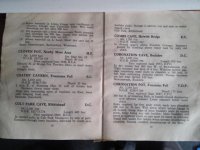
Colt Park Cave

andywebman

Active member
I am trying to locate any references or information on this cave on Park Fell, Ingleborough. The location description in NC vol 2 is completely wrong including grid ref but the older description in Pennine Underground gives a better location although it is not clear on the ground. Any info useful please. i have already contacted Burnley CC but their records for 1960 are no longer available.
 

Attachments

  • coltpark_PU.jpg
    coltpark_PU.jpg
    46.9 KB · Views: 222

Beardy

Member
Hi Andy

there is a mention in


Burnley Caving Club Review, Page 4, Published 2006
Title Nineteen Sixty

I have a copy at home i think - i'll try and find it later this week and send you a scan

regards
beardy
 

kay

Well-known member
At SD 77451 77663 there is a stream resurgence from the edge of the Colt Park Wood pavement, issuing from a boulder collapse.
 

andywebman

Active member
This is same grid ref as that in Northern Caves Vol 2. What other info is there. I would like to see the whole article
 

andywebman

Active member
I am aware of the resurgence at base of cliff mentioned by Kay above. This is the resurgence for Slab Cave (dye tested) Not convinced it is Colt Park Cave as it does not fit the description in PU.
 

kay

Well-known member
The BCC grid ref is the same as the one in NC. The PU grid ref is 773774, which would put Colt Park Cave as being more or less on a direct line between Slab Cave and the higher numbered Park Fell Holes. From memory, that would also put it into the gully of Slab Cave. It would also tie in with the NC comment of it being "probably the upstream section of Slab Cave" which makes no sense at all against the NC and BCC grid ref and location of the cave in the meadow below Colt Park Wood.


andywebman

Active member
P U Edition is the red covered one from 1965, in some places more reliable than Northern Caves, which has a number of errors. I hope to get hold of the original description from Burley CC shortly. The PU description will have been based on this. Did you see details in screenshot at top of this thread
 

kay

Well-known member
andywebman said:
Did you see details in screenshot at top of this thread

Yes, I did - that's how I was able to quote the PU grid ref in the first of my two emails ;-)

It suggests to me that if the PU grid ref is correct, then the BCC 2006 review quoted the NC grid ref rather than going back to the 1960 BCC description. The NC description is contradictory in that it describes Colt Park Cave as being the "upstream section of Slab Cave", then places it in a location downstream of Slab, namely "the pasture below Colt Park Wood". One part of that description has to be incorrect.


andywebman

Active member
Alt of 1160 ft corresponds to 354 metres. this right for a cave in the fields at Colt Park meadows but too high for the rising below Colt Park Wood in Ashtree Shaw Pasture Rocks.
 
Top