
DCA
Active member
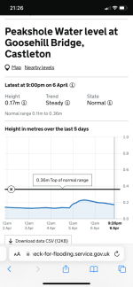
The Environment Agency have at last installed a water depth logger at Goosehill Bridge, Castleton. This is now live at:
https://check-for-flooding.service.gov.uk/station/9595
The water depth is updated every 15 minutes, and the datum is the crest of the weir that was installed in 1984/5 by the TSG and a group from Manchester Polytechnic. The metre ruler on the left bank of the river when looking downstream from the bridge has the same datum, so the levels on the web should be the same as the levels on the ruler. The outputs contributing to the total flow are Peak Cavern, Slop Moll, Peakshole Sough and Russet Well.
For those interested in the Bagshawe Cavern outflow, there is also a site on Bradwell Brook:
https://check-for-flooding.service.gov.uk/station/9475
")