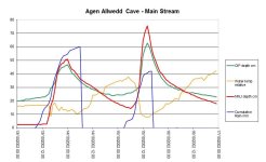
Well, there isn't much Aggy hydrology that I'm aware of besides what I collected in the early noughties. My wet places of interest were Northwest Junction Depth (NWJD) and Crystal Pool Inlet Depth (CPID) recording hourly depth in cm versus rainfall at home in mm which is near Llangattock. Charts attached for interest: I reset the cumulative rain tally to zero when each unsettled period ends.
Following over a week of dry weather, there was heavy rain on 12th Oct 2002 (first day of three wet ones) which did little to the cave river depth but it "primed" the system. What happened on 13-14th Oct was more dramatic than otherwise, see chart. Also the third dump of rain on Oct 14th was less than that on the 13th but it caused a bigger flood pulse.
Likewise bits of rain during 11-13th Nov simply primed the system and raised river level 10-15cm, then the big dump on 14th raised the level 40cm more. I hope obviously, if the river comes up half a metre during 6 hours then that's not like being hit by a dam burst but it could be somewhat inconvenient. Clearly main stream does flood dramatically, particularly with cumulative heavy rain, so my advice is give it a miss unless the weather is nice.