iphone 12 Pro - is going to be a revolution in cave surveying

ChrisJC

Well-known member
Phones have had 'Time of Flight' sensors in them for ages, one use is to determine whether your ear is adjacent to the screen (if it is, it disables the keypad).

https://www.st.com/en/imaging-and-photonics-solutions/proximity-sensors.html

In volume, about ?1.50.

I suspect the clever bit here is the software and decent accelerometers (so the orientation of the device can be accurately measured).

Chris.
 

pwhole

Well-known member
It does still suggest though that I should be able to buy a handheld waterproof LIDAR device of similar heft for about ?100 - if it had a range of around 25m I'd probably buy one, just to generate 3D models on the fly. I'd let the more careful types do the sketching. That would be very useful though, especially if trying to explain a digging problem to someone who wasn't there, like a boulder choke or a muddy crawl. Somewhere I really wouldn't want to take an iPhone.
 

nearlywhite

Active member
Rob said:
Exciting progressing of technology for sure, although the main challenge is what to actually do with the data. Are there any current LiDAR produced surveys or images that are actually better than "old tech"?

I helped with a project over in Tennessee that mapped a small cave like this and produced a coloured 3d model (with a google tablet though I can't remember the name).
The limitations were:
-significant error after 25m, significant survey drift (consistently >5%), this normally doesn't happen due to GPS correction but obviously underground...
-trying to turn it into useable 2d map remained a massive challenge and unearthed all of the differences in opinion of how to put together a survey e.g. where to put the walls in a rift, how to simplify the drawing etc
we ended up producing a 3d file that gives you about as much info as you can generate with Loch.
-it's a slow process and the processing time can become quite significant.

The medium term future of cave surveying is still producing a user friendly version of Therion. It's a very powerful tool. I've managed to get my topodroid sketching to the level that I can direct export with no follow up drawing. Sadly it's been a year since I did any surveying so lost the wind in my sails a bit.
 

mrodoc

Well-known member
It has occurred to me that with the limitations just outlined regarding accuracy. Lidar scan of particularly complex areas of cave eg junctions etc would be a usual adjunct when you are sketching or drawing a survey. People must have done this already with a tough camera ie photographed at each survey point on a trip (in a small cave). Has this been done. I thought it might help those of us who are rubbish at drawing.
 

andrewmcleod

Well-known member
nearlywhite said:
I helped with a project over in Tennessee that mapped a small cave like this and produced a coloured 3d model (with a google tablet though I can't remember the name).
The limitations were:
-significant error after 25m, significant survey drift (consistently >5%), this normally doesn't happen due to GPS correction but obviously underground...
-trying to turn it into useable 2d map remained a massive challenge and unearthed all of the differences in opinion of how to put together a survey e.g. where to put the walls in a rift, how to simplify the drawing etc
we ended up producing a 3d file that gives you about as much info as you can generate with Loch.
-it's a slow process and the processing time can become quite significant.

This is why the Caveatron looks like the 'right' idea to me (although probably not quite there yet). It (if I'm getting it right) uses a 'conventional' laser/compass survey to hang the LIDAR on, rather than trying to build the survey from the LIDAR. What I suspect you really want is the LIDAR collected at the time of surveying (and probably quite low resolution is fine - after all we draw the cave with a very small number of splays at each station) and displayed as an aid to the surveyor when sketching in wall etc. But that will take some clever processing on the tablet or whatever to convert the LIDAR into meaningful shades or whatever so you can see where the walls are.
 

nearlywhite

Active member
I've seen both set ups.

Interestingly Pete, Topo droid allows you to fix photos to stations and I know that people do use that feature, albeit for post surveying drafting. I still find it somewhat clunky and I'm not sure I could give a good 2D representation of a 3D space using a skewed 2D representation but it's all horses for courses. Always happy to optimise people's set ups if they're interested.

I'm about to tinker with the caveatron... I'll let you know if I ever get regular caving again  :cautious:
 

jariarkko

New member
Thanks Pete for posting my story above!

For background, I've been a DistoX user, but been experimenting with LiDAR since I got the new phone in February.

It has been an interesting experience. Amazing results, but also not smooth sailing either. I'm currently mostly focused on trying to make decent cross sections and simplified maps out of the 3D models. The article above goes through the process that I'm using as well as some of the issues that I'm struggling with. Although I've heard from some others that they've had easier time with even larger caves, but they were pretty simple tubes.

If you want to take a peek of a smaller model on your browser and how it looks like to rotate it on your screen, with all the texture in  place, try this link:

https://luolaseura.planetcaver.net/viewer.html?n=Grottbergetin%20luola,%20Siuntio&m=https://www.arkko.com/siuntion-luolat/Grottberget-3D-GLB.glb

This is from a 11-meter cave in Siuntio, Finland.  The actual 3D model is also embedded in the URL above, if you have local 3D tools such as Blender you may also grab that inspect it closer yourself.

Would love to hear from others who are doing this and what they use/what issues they have/what they do with it!


jariarkko

New member
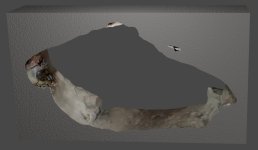
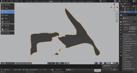
For the cross sections, I'd like to get something like shown in the attachments (first one from the same cave in Siuntio, another one from a cave in Vihti).

Both of these pictures are taken from the full 3D model, sliced up in Blender and shown in two different ways. You can actually slice the up in exactly the way you want, and you get an interesting perspective on things.

There's some difficulties, however, such as the Blender tools having been primarily made for objects and now we're dealing with spaces... it gets confused sometimes what's inside in intersection and other operators. Or maybe I'm confused. Still learning, and the 3D modelling tools have a pretty steep learning curve :)


Attachments

  • Grottberget-3D-crosssection-vertical1-better.jpg
    Grottberget-3D-crosssection-vertical1-better.jpg
    160.5 KB · Views: 164
  • blog916_blenda.jpg
    blog916_blenda.jpg
    443.7 KB · Views: 159
Top