You are using an out of date browser. It may not display this or other websites correctly.
You should upgrade or use an alternative browser.
You should upgrade or use an alternative browser.
Lovers walk
- Thread starter Dunna55
- Start date
alanw
Well-known member
A mention here: https://webapps.bgs.ac.uk/memoirs/docs/B01566.html
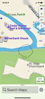
The tops of three such knolls are readily accessible in the south bank of the River Derwent north of St. Giles's Church, Matlock.
A cave shown in the vicinity on the OS 25" map circa 1900:

The tops of three such knolls are readily accessible in the south bank of the River Derwent north of St. Giles's Church, Matlock.
A cave shown in the vicinity on the OS 25" map circa 1900:
History Trog
Member
For the last three months I have been drawing up the vein maps and diagrams to accompany my definitive book on the Matlock Bath which PDMHS are hoping to publish eventually. Have worked up the west side from Cromford and now on Masson so have not yet done the east side of the river. I use the local library for internet access and do not have access to my own data but will look when I get home and be back online tomorrow. Think it was not important, as paul has suggested. From our 1980 odd article on the Masson system, the area map for that site does not
help much.

help much.
danthecavingman
Member
Did anyone ever find the 'lightly gobbed up gate' by the twin trunked Elm Trees (?) above Lovers Walk near here? The story told at the time sounded very interesting with some potential for exploration. Sure there's a thread on here somewhere 🤷🏻♂️
speleokitty3
New member
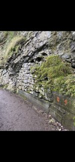
Ladygate Mine is a little down river from the walled-up feature. That was open in the 1940's and 50's (no I'm not that old but my Mother went in there) but was later sealed up by the local council. It opened up again a few years ago before being resealed. We had a look around it when it was more recently open and noticed child size clog marks in some areas but its not clear if they were working in there or later explorers.
The feature in the photo looks pretty much unchanged since I first saw it in the 1950's and I've often wondered if it concealed something more substantial. Some of the early OP Mole records mentioned several entrances in this area (some of them blocked) but without any specific location.
There is another entrance just upstream and to the right above the confluence with Bently Brook. This ran for a little distance towards the church but I don't know if it is still open as I remember people asking for it to be blocked in the 1980's and 90's as it was being used as a glue sniffing den etc.
AR
Well-known member
Looked for it but didn't find it - keep meaning to ask Boy Engineer for the loan of his infrared camera to see if there's any ground obviously warmer than the surroundings.Did anyone ever find the 'lightly gobbed up gate' by the twin trunked Elm Trees (?) above Lovers Walk near here? The story told at the time sounded very interesting with some potential for exploration. Sure there's a thread on here somewhere 🤷🏻♂️
History Trog
Member
Looked for it but didn't find it - keep meaning to ask Boy Engineer for the loan of his infrared camera to see if there's any ground obviously warmer than the surroundings.
The extract from the Barmaster’s maps suggests that the walled-up opening was on Bradshaw Vein and it cites the entry on p.26 of Book 45, which is as follows:For the last three months I have been drawing up the vein maps and diagrams to accompany my definitive book on the Matlock Bath which PDMHS are hoping to publish eventually. Have worked up the west side from Cromford and now on Masson so have not yet done the east side of the river. I use the local library for internet access and do not have access to my own data but will look when I get home and be back online tomorrow. Think it was not important, as paul has suggested. From our 1980 odd article on the Masson system, the area map for that site does not
help much.View attachment 18208
27 May 1807 Then gave James Ludlamb from the Bruck at the Botham of the hawlees in hawlees Vein Twelve meares Rainging over the Hills to the River Darwent in the piggtree And Nine meares in the Ladygate vein from the River Darwent in the Piggtree to the South side of a piece of Land none by the name of Armes Croft And from the West side the Ladygate in Lows Croft Six meares in the Hills Vein or to the River Darwent or be the same more or Less And from the South side the Parsons Archard in some Old holes 4 meares Rainging near South up William Godwards Close Gave them for the Dimple Mess:
Twenty four men John Knowles and George Holmes.
This gift was for the owners of Dimple Mine.
The details of Bradshaw Vein come off a plan of Stoneyway Title 1856. Nothing more is known of it.
Probably insignificant – there are no signs of a vein visible on the adjacent rock. Can never be sure tho’ – the small openings just across the river in a quarry face were the Harveydale Quarry Tubes, an extensive phreatic cave system connecting to an engine shaft on Seven Rakes.
History Trog
Member
The extract from the Barmaster’s maps suggests that the walled-up opening was on Bradshaw Vein and it cites the entry on p.26 of Book 45, which is as follows:
27 May 1807 Then gave James Ludlamb from the Bruck at the Botham of the hawlees in hawlees Vein Twelve meares Rainging over the Hills to the River Darwent in the piggtree And Nine meares in the Ladygate vein from the River Darwent in the Piggtree to the South side of a piece of Land none by the name of Armes Croft And from the West side the Ladygate in Lows Croft Six meares in the Hills Vein or to the River Darwent or be the same more or Less And from the South side the Parsons Archard in some Old holes 4 meares Rainging near South up William Godwards Close Gave them for the Dimple Mess:
Twenty four men John Knowles and George Holmes.
This gift was for the owners of Dimple Mine.
The details of Bradshaw Vein come off a plan of Stoneyway Title 1856. Nothing more is known of it.
Probably insignificant – there are no signs of a vein visible on the adjacent rock. Can never be sure tho’ – the small openings just across the river in a quarry face were the Harveydale Quarry Tubes, an extensive phreatic cave system connecting to an engine shaft on Seven Rakes.View attachment 18210
Boy Engineer
Active member
As soon as my CBA muscle has recovered I’ll pop up there and have another look. Could do with a cold snap first, rather than the current murk.Looked for it but didn't find it - keep meaning to ask Boy Engineer for the loan of his infrared camera to see if there's any ground obviously warmer than the surroundings.
History Trog
Member
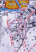
I have resurrected this thread as I am now working on diagrams for the chapter of my book dealing with the Matlock Town area. Attached is a small snippet covering the Pig Tor area taken from the top of my A3 size area map for High Tor and Hard Rake – Riber Mine. It is based on the 2nd Ed 25 inch OS map downloaded from the National Library of Scotland website.
It is awkward because I know of so little exploration underground thereabouts, only the short levels at Cawdor.
Speleokitty mentioned having got into the level at Pig Tor on Ladygate Vein when it was open a few years. I am annoyed that I missed that because would have liked some photos and the chance to examine the vein. The lead miners attached enormous importance to the northern range of Ladygate, treating it as some sort of master vein.
Does anyone out there have any knowledge of underground exploration in the Matlock Town – Dimple area?
Attachments