
Stuart France
Active member
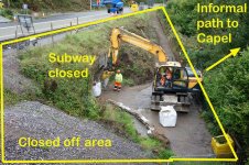
A few days ago Costain blocked off access through the subway under the A465 near the former Drum & Monkey pub with a metal fence. This was the route used by most cavers to reach Ogof Capel, and for walkers to reach Devils Bridge and the Cwm Clydach National Nature Reserve when coming from Blackrock village.
The subway will become a bat roost and it looks like they intend to wall off one end of it because a couple of ton-bags of sand have just been dropped off (see photo). Unfortunately, the informal path used to reach Ogof Capel is marooned in this area, and one imagines those walling up the subway next week won't be keen on visitors. The public footpaths adjacent to the subway portals have been abolished as part of the A465 dualling scheme.
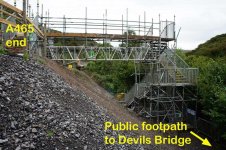
The path to Ogof Capel that started near the subway (see photo) is on government forestry land, as is the cave entrance, and this is also in the Mynydd Llangattock SSSI. Although not shown on the OS Map as CROW Access Land, it ought to be since most if not all government forestry has been dedicated as Access Land, although this forestry here is non-commercial.
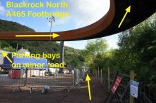
Simultaneously, Costain have opened the new ?rusty finish? footbridge above Blackrock, and this is the new pedestrian route from the village into the gorge. There is roadside parking at the village end of this footbridge. You then walk parallel to the A465 downhill for a couple of hundred yards to a temporary scaffold footbridge which lands at the top of the concrete steps leading down to Devils Bridge - but it does not connect with the usual informal path to Ogof Capel.
All is not lost. As it happens, there is a little-known alternative path to the cave running through the woods adjacent to the new scaffold tower.
Stuart France
Cambrian Caving Council
The subway will become a bat roost and it looks like they intend to wall off one end of it because a couple of ton-bags of sand have just been dropped off (see photo). Unfortunately, the informal path used to reach Ogof Capel is marooned in this area, and one imagines those walling up the subway next week won't be keen on visitors. The public footpaths adjacent to the subway portals have been abolished as part of the A465 dualling scheme.
The path to Ogof Capel that started near the subway (see photo) is on government forestry land, as is the cave entrance, and this is also in the Mynydd Llangattock SSSI. Although not shown on the OS Map as CROW Access Land, it ought to be since most if not all government forestry has been dedicated as Access Land, although this forestry here is non-commercial.
Simultaneously, Costain have opened the new ?rusty finish? footbridge above Blackrock, and this is the new pedestrian route from the village into the gorge. There is roadside parking at the village end of this footbridge. You then walk parallel to the A465 downhill for a couple of hundred yards to a temporary scaffold footbridge which lands at the top of the concrete steps leading down to Devils Bridge - but it does not connect with the usual informal path to Ogof Capel.
All is not lost. As it happens, there is a little-known alternative path to the cave running through the woods adjacent to the new scaffold tower.
Stuart France
Cambrian Caving Council