• CSCC Newsletter - May 2024

    Available now. Includes details of upcoming CSCC Annual General Meeting 10th May 2024

    Click here for more info

Slaley Sough

Some time ago, I wrote up a detailed history of the Bonsall Leys Mining Company but didn't get round to finishing it off because of being overwhelmed by research for the Matlock book.
All the material from the No.2 Level was taken out of the adit. Much of the limestone was sold at 6d per ton - hardly economic though. Miners simply tolerated cramped working conditions - think of coffin gate levels. There was no lower level linked with it.

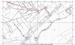
The longest drive done by the company was of course the No. 3 Level which ranged from the road side and beneath Parish Quarry. By the time I got on the scene (c1966) this had collapsed beneath the quarry floor but Nellie Kirkham's papers include a good survey by Doug Nash and Op Mole. It was heading for the Horsedale Mines but was a similar complete failure  - I made its recorded driveage (not including side passages) as 2298 feet.

Prosperous Mine was a subsumed into the Slaley Sough Title. It may have exploited a small rich pipe on top of the lava flow. There may have been a feeling that there must be some rich deep deposits on the south side of Bonsall Moor comparabel to Gorseydale and Slack mines on the north side.
 

Madness

New member
Thanks for the info History Trog. Looking forward to reading your Matlock book once it's published.

Do you know if all of the raises have been climbed to their conclusion and if so whether they meet solid rock or a collapse/choke?
 

Tripod

Member
It was from No3 Level that the redundant Millclose miners emerged from having entered Jugholes prospecting for Lead to work on their own behalf. Well - that is the story I was told (coincidently, that was in 1966) and it came from what could be regarded as a very reliable source. However, the story could be taken literally or as a statement on how widely the miners searched. It could also have been a ploy intended to divert cavers from nosing around where they were not wanted. There were a lot of stories around at that time - and some since - about mines connecting, maybe with less knowledge of what has been lost and overall what had possibly been there earlier.   
 
In response to the query by Madness, I was not at all intrepid underground and so never attempted to explore the raises in No. 2 Level.

The following details are extracted from my unpublished article:

The cross vein at the end of the entrance level is Flixen Vein and a raise in its eastern length was made in 1857 and a short level driven under the toadstone, looking for any enrichment.

The 4th Raise was made in the roof up to the toadstone at a point 755 feet beyond the 3rd Raise, the Committee inspected:
the rise to the Toadstone and finding the Veins wider and some ore visible recommend that the Agent continue driving in the roof northwardly immediately under the Toadstone?.
Only four days later, this instruction was countermanded but instead the forefield remained static whereas over ?57 was spent on the drive under toadstone which was perhaps about 20 fathoms in length.

The 2nd raise by the old man?s workings must have been an old shaft through the toadstone and its presence was obviously totally unsuspected by the 1850s company. It would have been a series of shafts stepped down from the surface rather than one deep engine shaft, similarly to those at the Black Rakes near Middleton-by-Wirksworth.

The raises in No. 2 Level hold little prospect.

In some mines, e.g. the Old Gells Adit in the Via Gellia, there would be some potential in exploring upwards although the stablility of the stopes looks rather disastrous.

As regards connections, we were told that No. 2 Level linked to the level opposite the Barley Mow in Bonsall but it was all codswallop. However, a few rumours have proved correct e.g. the Youd's Level (Masson Sough) was rumoured to exist long before it was found, and the Ball Eye - Matlock Bath sough certainly existed.
 

Madness

New member
I thought it was rumoured that the level opposite the Barley Mow came out near the quarry, so perhaps it's more likely to be level 3
 

Madness

New member
Finally got around to going back to Slaley tonight.

We climbed the raise with the stuck wire. I'm not sure if that's the third or forth raise. It went up for thirty odd feet where it met a layer of toadstone clay. It had obviously been widened by miners due to drill holes being evident. Unfortunately,it stopped once it met the toadstone. The stuck wire and some chipped holds suggest previous exploration
 

zomjon

Member
You won't need one, not too complex, but quite interesting for a couple of hours, maybe combine with Dunsley Spring.
 

ttxela2

Active member
LarryFatcat said:
We have trip planned early in the new year, anyone got any descriptions/surveys of Slaley?

Muddy in parts  :LOL:

Rogers survey is in one of the PDMHS journals, I had a copy but I think I leant it to someone long ago.....
 

al

Member
You won't need a survey, there's not a lot of route choice once you're through the crosscut!

Hardest bit's probably finding the place. Best method I reckon is as follows: park as for Goodluck, walk (very carefully - this is the dodgy bit) down the road towards Via Gellia until you see the Bonsal Lees level entrance on your left, and then try to spot the next stream which is flowing down the hill on the left (helps if it's wet weather obvs) and follow it uphill. You should get to a spoil mound, and then the (foxy) entrance.
 
The survey made by myself and Andy Hayes can be seen on:
https://pdmhs.co.uk/MiningHistory/Bulletin%204-6%20-%20The%20Adit%20Workings%20on%20the%20North%20Side%20of%20the%20Via%20Gellia.pdf

Slaley Sough (Bonsall Leys Level) is a monument to over-optimism of the miners.
 

Lampwick

Member
We've re-surveyed the main passages in Slaley Sough to check out the correlation with surface features.  I'd always wondered why the text stated that the passage followed Parson's Rake, but with the sketch map showing it further south... now we know.
 

Attachments

  • Bonsall Leys Map.jpg
    Bonsall Leys Map.jpg
    473.9 KB · Views: 200

Fishes

New member
I have seen similar differences between old and modern surveys of mine workings. You have to take into account local changes in magnetic deviation from when the original survey of mine workings was done to your own and even if this was taken into account at the time. When I overlaid modern survey work on the 18th century plan of the mine workings around Jug Holes by Nutall they didn't match up until we took both into account.
into our calculations.

Also you need to be careful about how you interpret veins from Barmaster's maps and surface remains. When we surveyed Barley Close Mine in Wensley, the workings actually ran at 90 degrees  to what we expected.


Parsons Rake is a strongly hading vein and therefore at depth would be substantially out of line of its surface expression. Also many rakes step sides when passing through the lava flow.
 
Top