Stoney Middleton Silt Dredging/Flood Management

AR

Well-known member
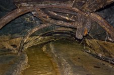
I can't help but wonder whether the problem with Moorwood Sough is that if its flow is obstructed, the water backs up and finds its way out of the earlier (and precise location unknown) Middleton Mill Sough. It's certainly lower than Stoke, but a little higher than Moorwood so making sure Moorwood can handle heavy flows does have a benefit.
 

Fishes

New member
Moorwood Sough was blocked in many places before OP Mole reopened it. I'm not aware that flooding was worse than before it was opened.

Its a long time since I was in the sough but from memory there were two inlets into the lower end of the sough. One came from the Roman Baths and was noticeably warmer than the water in the sough. The other I think was fed by a drain from somewhere on the north side of the village. If these inlets were blocked then it might cause some flooding

On one occasion I visited the area the Middleton road was flooded all the way across but all the water seemed to be coming from the culvert by the substation which was blocked at the time.


caving_fox

Active member
PeteHall said:
You could do, but not sure why you would bother; is this a hypothetical question or are you worried about a house you're planning on buying? If it's an old house and it hasn't fallen down, it's probably ok. If it's a new house in a mining area, it should have been checked as part of the planning process.

GPR (ground penetrating radar) is not the most conclusive of tools and only measures so far into the ground, so I'm not sure it would be the right tool. Any intrusive investigation (eg boreholes) would cost thousands, so not really economical for a house-buyers survey. Depending on the depth of workings, the borehole rig could be quite sizeable too.

A record search would be a good starting point and relatively inexpensive.

A conveyencing solicitor chooses what searches are performed as part of the house-buying process. Those with local knowledge would certainly include mine records for houses in the appropriate parts of the county. (and you can request them if they aren't included) However there are a huge number of potential searches each of which cost, so it may not be done de-facto unless there's an indication it's necessary. But as above, you've then the problem of if you find you have mine workings beneath your property, how do assess whether they are a problem or not? (and of course not all mine workings are properly recorded).
 

bograt

Active member
I suspect a lot of the flooding problems originate from Sallet Hole mine and Cavendish Mill, whilst it was working the water in the lower levels of the mine was pumped up to drain through a sough at about 60ft below the current entrance, I understand that upon closure the tailings dam was breached allowing its contents to flood into the mine workings, this would have the effect of silting up the whole of the lower workings up to adit level, 9ft above the entrance gate, hence causing the current flow out of the mine and down the local highways.
With the breaching of the dam, water and silt would have been released into every natural watercourse downstream of Cavendish Mill and I suspect this is what is causing the problems being encountered today.       
 

PeteHall

Moderator
I'm afraid I have no knowledge of the hydrology of this area, or the intricacies of the mine drainage, but as a general rule, blocking or slowing flow upstream, reduces peak flow and therefore flooding downstream.

All modern drainage systems are specifically designed to hold back peak flows through the incorporation of permeable surfaces to slow run-off to the system, attenuation ponds, tanks, or oversized pipes,  to hold back peak flows and release them slowly after the storm event.

An abandoned mine (assumed to be upstream) is likely to hold a huge volume of water if the adit is partially blocked, forming a natural flow control. Water levels will increase during a storm event as the water won't get out as fast as it comes in. This will then drain down over time, at a lower flow rate.

Clearing the adit will simply allow all the water from a storm event to escape straight away,  at a much higher flow rate,  increasing the problem.

Clearing blockages through the village, or further downstream will allow the water that is coming out to escape quicker and reduce flooding in that area, but it will in turn increase the flow rate, and hence flood risk, further downstream.
 

Fishes

New member
I thought water from Sallet Hole Mine would flow down Coombs Dale rather than into the village.

I thought that the dam that failed was to allow crap in the water from the roadways around Cavendish Mill rather than one of the tailings dams. I'm sure TPot could give us more detail on that one.
 

Mark

Well-known member
Judi Durber said:
Katie said:
It is under a drive way rather than a house, and solidly capped from what I understand!


I am guessing it is under the round manhole?

The shaft is under the manhole by the van, the manhole drops into a circular chamber about 1.2m high x 2.0m diameter. There are two plastic pipes through the floor about 200mm diameter, it would be quite easy to create a manhole access in the floor of the chamber.

It would never be an entrance accessible to cavers, but the shaft could certainly be inspected from there, or a camera could  be lowered through the holes.
 

PeteHall

Moderator
Mark said:
The shaft is under the manhole by the van, the manhole drops into a circular chamber about 1.2m high x 2.0m diameter. There are two plastic pipes through the floor about 200mm diameter
This one?

Bloody hell that's close to the house! I hope they had a good geotechnical engineer sign that off  :eek:
 

Attachments

  • Capture.JPG
    Capture.JPG
    87.9 KB · Views: 131

PeteHall

Moderator
Speleotron said:
Why does the house have such tiny windows?

Way off topic, but it's probably to do with the fact that the side elevation of that building (3 x 2 bed apartments) overlooks previously existing houses. There are bigger windows on the front elevation. I should caveat that I'm not a planner or an architect, but I've sat through enough meetings with them an engineer working on similar residential developments...

You can read the waffle the planner wrote about it in the Design and Access Statement if you are truly bored: https://portal.peakdistrict.gov.uk/result/YToyOntzOjE0OiJPYmplY3RfVHlwZV9JRCI7czoxOiI3IjtzOjE2OiJPYmplY3RfUmVmZXJlbmNlIjtzOjE2OiJOUC9EREQvMDgwNC8wODc1Ijt9
 

pwhole

Well-known member
bograt said:
I suspect a lot of the flooding problems originate from Sallet Hole mine and Cavendish Mill, whilst it was working the water in the lower levels of the mine was pumped up to drain through a sough at about 60ft below the current entrance, I understand that upon closure the tailings dam was breached allowing its contents to flood into the mine workings, this would have the effect of silting up the whole of the lower workings up to adit level, 9ft above the entrance gate, hence causing the current flow out of the mine and down the local highways.
With the breaching of the dam, water and silt would have been released into every natural watercourse downstream of Cavendish Mill and I suspect this is what is causing the problems being encountered today.     

When I was in Sallet Hole years ago we followed a raging torrent down a concrete-slab floored decline for a couple of hundred of metres at least - I assume eastwards but it was my first trip so I wasn't really checking. At the bottom was the scene below - I think it was Sub-Level 3, or close to it. This area is of considerable interest to me as drainage from that end would go down Brightside Sough, I would have thought, via Backdale Mine if it was still connected. I have a few sketches that imply that was the case. Is that the sough you mean?
 

Attachments

  • _IGP7550_sm.jpg
    _IGP7550_sm.jpg
    301.9 KB · Views: 134

nickwilliams

Well-known member
PeteHall said:
, all this info will be on the local planning portal, where you should be able to find detailed plans of the shaft location, inspection records, the geotechnical engineers report and capping detail.

I'm not aware that the PDNPA have any records of this nature for any site in The Park. Is the collection of this information a requirement of national planning framework guidance or just considered to be good practice?
 

PeteHall

Moderator
nickwilliams said:
PeteHall said:
, all this info will be on the local planning portal, where you should be able to find detailed plans of the shaft location, inspection records, the geotechnical engineers report and capping detail.

I'm not aware that the PDNPA have any records of this nature for any site in The Park. Is the collection of this information a requirement of national planning framework guidance or just considered to be good practice?

Any information required to gain a planning approval should be publicly available on the planning portal these days. Depending on the size of the development, there can be more or less assessment required to get through planning, but there will always be a base level required.

Strangely, I had all the submission documents and responses open earlier (via the link I posted), but now I can't see anything except the application details; the documents list has vanished... Either the website is crap, or I'm going mad!
[edit: I'm not going mad, I still have all the documents I looked at in my downloads, even if I can't get to them on the website any more]

I did not see a ground investigation report when I was looking earlier, though this would have certainly been required to assess the contamination and specify the remediation works, though this could have been dealt with via a separate application. I also didn't see any drainage or highway designs, so I suspect that PDNPA aren't very good at uploading everything...

The drawings which were uploaded were scanned documents, rather than electronic files, so things like a 300 page ground investigation report may have been omitted due to file size.

I didn't bother to read the EHO response, but that may have shone some light on what was submitted.
 

A_Northerner

Active member
PeteHall said:
I'm afraid I have no knowledge of the hydrology of this area, or the intricacies of the mine drainage, but as a general rule, blocking or slowing flow upstream, reduces peak flow and therefore flooding downstream.

All modern drainage systems are specifically designed to hold back peak flows through the incorporation of permeable surfaces to slow run-off to the system, attenuation ponds, tanks, or oversized pipes,  to hold back peak flows and release them slowly after the storm event.

An abandoned mine (assumed to be upstream) is likely to hold a huge volume of water if the adit is partially blocked, forming a natural flow control. Water levels will increase during a storm event as the water won't get out as fast as it comes in. This will then drain down over time, at a lower flow rate.

Clearing the adit will simply allow all the water from a storm event to escape straight away,  at a much higher flow rate,  increasing the problem.

Clearing blockages through the village, or further downstream will allow the water that is coming out to escape quicker and reduce flooding in that area, but it will in turn increase the flow rate, and hence flood risk, further downstream.

I think the issue is that these mines line the dale, and due to blockages even a slightly above average amount of rain quickly spills across the width of the road and down into the village.
 

nickwilliams

Well-known member
PeteHall said:
Strangely, I had all the submission documents and responses open earlier (via the link I posted), but now I can't see anything except the application details; the documents list has vanished... Either the website is crap, or I'm going mad!

The website stopped responding to me and gave a 500 error at around 23:00 last night. It seems to be OK again now.
 
Top