I did O level geography 40 years ago so I?m no expert but have always been interested in this stuff.
My understanding is that glaciation reached the south of England so terminal moraines would be found down there. As the glaciers retreated they paused at various places forming recessional moraines. Although, having looked at Swinner Gill on a map, it appears to be V shaped so probably not formed by a glacier.
I was just googling it to see if I could find out any more and discovered this... https://en.wikipedia.org/wiki/Kisdon
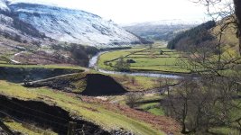
Kisdon, the hill opposite the mouth of Swinner Gill has deep valleys running either side of it. The original route of the River Swale was to the west but that was blocked by a recessional moraine forming a large lake upstream. This cut through the hill to the north of Muker forming a deep V shaped canyon and changing the course of the river. So the section from Muker, past the mouth of Swinner Gill to Kisdon Force is all water formed.
I wonder if the moraine you mention was formed by the river washing debris up into Swinner Gill as it went around the bend in the valley.
As you can probably tell, I?ve got a bit too much time on my hands today