

You are using an out of date browser. It may not display this or other websites correctly.
You should upgrade or use an alternative browser.
You should upgrade or use an alternative browser.
The Mossdale tragedy
- Thread starter andychapm
- Start date
Weather forecasts are never 100% accurate but general areas where it might rain within 6,8,12 or 24 hours. It's obviously impossible to predict the position of a particular shower or how much rain will fall. I think in general terms it would be possible to predict with reasonable certainty that there will or won't be a heavy downpour in Yorkshire, today or tomorrow, and plan accordingly.
Article as it's now 50 years ago:
http://www.harrogateadvertiser.co.uk/news/the-fell-rescue-column-with-david-dennis-1-8674994
Mike
http://www.harrogateadvertiser.co.uk/news/the-fell-rescue-column-with-david-dennis-1-8674994
Mike
rhychydwr1
Active member
Latest info:
Descent (256) June/July 2017 24-25 32 photos. Mossdale a Survivor?s Story by Collette Lord.
Descent (257) August/September 2017 Mossdale: 50 Years On 11 one photo of a cairn directly over Far Marathon Passage where the cavers died.
Descent (256) June/July 2017 24-25 32 photos. Mossdale a Survivor?s Story by Collette Lord.
Descent (257) August/September 2017 Mossdale: 50 Years On 11 one photo of a cairn directly over Far Marathon Passage where the cavers died.
alastairgott
Well-known member
After some of Simon's reports last week, I was reading up on this hillside.
One thing that puzzles me is that from a glance at the surveys Mossdale seems to stretch to the South and East, is that correct?
Langcliffe pot seems to stretch to the South east and then East (potentially directly underneath a lead rake?)
Yet, The dye trace for that hillside suggests that Black Keld is the resurgence, and that is to the West.
Is Mossdale formed on a bedding plane?
Are there any passageways in Langcliffe which match up? (If it were a bedding?)
Simon Beck
Member
alastairgott said:After some of Simon's reports last week, I was reading up on this hillside.
One thing that puzzles me is that from a glance at the surveys Mossdale seems to stretch to the South and East, is that correct?
Langcliffe pot seems to stretch to the South east and then East (potentially directly underneath a lead rake?)
Yet, The dye trace for that hillside suggests that Black Keld is the resurgence, and that is to the West.
Is Mossdale formed on a bedding plane?
Are there any passageways in Langcliffe which match up? (If it were a bedding?)
I thought Mossdale was mostly joint guided.
There are a few articles which speculate on why the resurgence is up dip.
I would say there is little comparison between the two (mossdale/langcliffe) enough to draw conclusions that is. The obvious similarities are well documented.
alastairgott
Well-known member
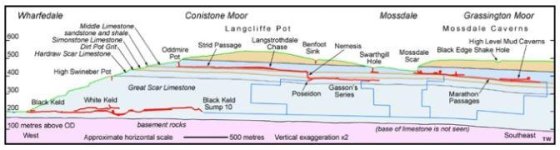
I've rooted out the section of Caves and Karst of the Yorkshire dales (27) that deals with Grassington Moor.
It seems that the upper passageways of Langcliffe are developed on a bedding (of sorts) in Middle limestone. Then there is a drop, Nemesis which brings the lower passages past simonstone limestone and into Hardraw scar limestone.
Mossdale seems to be developed along a bedding of sorts in Middle limestone, with only dye traces going below middle limestone.
Simon, any progress downwards in Mossdale should lead to some good stuff! Your reports have us on the edge of our seats.")
Great scar limestone is below Hardraw scar limestone, and is the level that Black keld is in.
It seems that the upper passageways of Langcliffe are developed on a bedding (of sorts) in Middle limestone. Then there is a drop, Nemesis which brings the lower passages past simonstone limestone and into Hardraw scar limestone.
Mossdale seems to be developed along a bedding of sorts in Middle limestone, with only dye traces going below middle limestone.
Simon, any progress downwards in Mossdale should lead to some good stuff! Your reports have us on the edge of our seats.
Great scar limestone is below Hardraw scar limestone, and is the level that Black keld is in.
Simon Beck
Member
Not sure what you mean by 'of sorts'? But certainly in Mossdale, and to my un-formally-trained eye, even on the sandstone it appears heavily joint guided for the majority.
It could be tomorrow, or, for me, it could be never, and I could just be a stepping stone for the next lot. Regardless, It's still a major step forward up there, and all within a very short period of time.
It could be tomorrow, or, for me, it could be never, and I could just be a stepping stone for the next lot. Regardless, It's still a major step forward up there, and all within a very short period of time.
alastairgott
Well-known member
Simon Beck
Member
I have a copy of this yes. I'm afraid my only field of expertise comes from actually visiting the venue, which taught me far more than any piece of material I've ever read on the place. There are lots of folk with a better understanding of the geology that can shed better light on your questions than me.
One thing that puzzles me is that from a glance at the surveys Mossdale seems to stretch to the South and East, is that correct?
Langcliffe pot seems to stretch to the South east and then East (potentially directly underneath a lead rake?)
According to the CaveMaps survey, Nowty Hole and Langcliffe Pot are both on that lead rake. When Nowty Hole is open, is it possible that Mossdale Beck drains to Langcliffe Pot rather than via Mossdale's Dull North as previously thought?
Simon Beck
Member
No conclusions about Nowty Hole were ever drawn though, so it's all just mere speculation. That goes for the source of the Dull North water as well.
I'm almost convinced that the Swarthgill Hole water is that which appears in New Fearnought, but until it's proven a guess is all it will ever be.
I prefer the doing, where those caves are concerned, to the talking about it, which over the years totally ground me down from other cavers. There used to be a lot more experts on mossdale but I'm not sure where they've all gone now.
alastairgott
Well-known member
I prefer the doing as well, there's good teamwork with it.
You've put the hours in, and know the system back to front. If anyone's going to find more new stuff in there, it'll be you.
You've put the hours in, and know the system back to front. If anyone's going to find more new stuff in there, it'll be you.
Simon Beck
Member
alastairgott said:I prefer the doing as well, there's good teamwork with it.
You've put the hours in, and know the system back to front. If anyone's going to find more new stuff in there, it'll be you.
Sorry, wasn't referring to you as a talker btw.
Of those I've met over the years with grand plans for those venues and projects on Grassington Moor almost non of them ever got past talking about it. Spoke to someone recently about the lost mines, I almost said at the time I'll believe it when I see it. Don't mean to be critical, but if you were me, believe me you'd be sick of it. From some folk it comes across as an attempt to belittle.
