Stoney Middleton Silt Dredging/Flood Management

A_Northerner

Active member
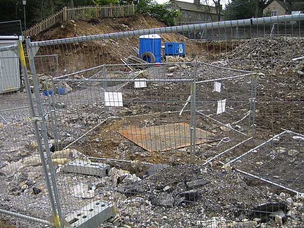
Evening all, big news in Stoney Middleton is that a long overdue de-silting is taking place in the village. The local flood management group have been trying to get it done for years since the dam broke in 2007. The council removed debris from the stream but never did a desilting which has led to massive floods in Stoney ever since. Apparently it used to be done a lot more regularly. They've removed 6 tonnes so far, last time it was done they took 20 tonnes total.

Thought it might be of passing interest to cavers in the area. The lead campaigner for the Stoney Flood Group has mentioned that cavers used to help out with clearing streams and various soughs in the area (group of "Old Blokes with beards from Op Mole" according to one resident) but there's been no involvement for over 10 years. He's keen to get cavers back involved though and says he's been meaning to get the bottom of Moorwood Sough root cut/inspected by the council for a while as it's been left to overgrow, and is a particular contributor to recent floods. He quoted John Gunn's study on the hydrology of the area and in particular the part where John recommends regular cutting of Moorwood Sough to manage floods in Stoney, as well as opening up Glebe Shaft for inspection as well, none of which is done regularly any more.

Does anyone have any personal experience of helping Stoney residents with waterway clearance for flood management, is it something that could be kick-started again?

Picture is from a resident of the current silt dredging.

98184921_2686325441694246_8852031067113127936_o.jpg
 

Fishes

New member
John Beck and Doug Nash used to be involved in clearing the culverts.

Doug was the founding member of Op Mole.

Not much chance of opening Glebe shaft now.
 

Mark

Well-known member
Fishes said:
John Beck and Doug Nash used to be involved in clearing the culverts.

Doug was the founding member of Op Mole.

Not much chance of opening Glebe shaft now.

Glebe shaft could be re-opened very easily.
 

Pete K

Well-known member
This seems like something DCA could help get back up and running again. Can you put me in touch with them or pass on my DCA email please?
projects@thedca.org.uk
Ta
 

nickwilliams

Well-known member
Mark said:
Glebe shaft could be re-opened very easily.

Here is a picture of when it last saw the light of day:

img_1187.jpg


There are some more pictures of the site clearance here:

http://www.tinpuffin.com/caving/GLEBE/townhead.html
 

Katie

Active member
It is under a drive way rather than a house, and solidly capped from what I understand!
 

A_Northerner

Active member
Pete K said:
This seems like something DCA could help get back up and running again. Can you put me in touch with them or pass on my DCA email please?
projects@thedca.org.uk
Ta

Sounds good Pete, I was going to suggest getting in contact with you but didn't want to namedrop you unless you were actually keen.

I'll send the email over now.

Katie said:
It is under a drive way rather than a house, and solidly capped from what I understand!

So Glebe Shaft is totally unaccessible these days? Doesn't bode well, Prof. Gunn stressed its particular importance in his work for EA. Said it needed inspecting regularly. Any other way in?
 

PeteHall

Moderator
Speleotron said:
Is it a bit dodgy to build a house over an old mine like that or is it just a fact of life round there?

Typically, you would expect the geotechnical engineer to specify an offset from capped mine shafts for any proposed dwellings. 25m would be typical, but it can vary depending on the ground conditions. If you are interested, all this info will be on the local planning portal, where you should be able to find detailed plans of the shaft location, inspection records, the geotechnical engineers report and capping detail.

Deep shafts tend to be less problematic than shallow underground workings as these can be much older and therefore less well recorded, so significant investigation can be needed to identify if/ where they exist. It's a common issue in many parts of the country.
 

aardgoose

Member
From John Beck's survey ( Glebe shaft marked and the other one found when the road in the square was repaired!)... looks like the orange van might be parked on top of it.
 

Attachments

  • eyam-square.png
    eyam-square.png
    153.8 KB · Views: 198

PeteHall

Moderator
You can see the shaft on Google Earth if you wind the date back to 2005. Flicking forward to 2010 it looks like the shaft is under the curved bit of wall between the drive and the road.

The info on the planning portal is fairly scarce, but I'm very surprised they were allowed to build a 3 storey house 5m away from a capped mine shaft!  :eek:
 

Speleotron

Member
If you're thinking of buying a house can you have a radar survey carried out to see if there's any mines under the property?
 

PeteHall

Moderator
You could do, but not sure why you would bother; is this a hypothetical question or are you worried about a house you're planning on buying? If it's an old house and it hasn't fallen down, it's probably ok. If it's a new house in a mining area, it should have been checked as part of the planning process.

GPR (ground penetrating radar) is not the most conclusive of tools and only measures so far into the ground, so I'm not sure it would be the right tool. Any intrusive investigation (eg boreholes) would cost thousands, so not really economical for a house-buyers survey. Depending on the depth of workings, the borehole rig could be quite sizeable too.

A record search would be a good starting point and relatively inexpensive.
 

Fishes

New member
I don't actually think that access to Glebe Shaft is important when it comes to the flood prevention.

Keeping the culverts clear and the bottom end of the sough seem to be the main areas that affect flooding in the dale.
 

pwhole

Well-known member
Has anyone in recent times (big question!) ever calculated the percentage of underground water that leaves the system at the Ladywash end via Stoke Sough? I've never been sure if there's a 'watershed' (natural or artificial) in Glebe Mine that split the water toward one sough or the other - I'm not familiar with the lower passages other than the main drive to Ladywash. I know that Stoke Sough had to be cleared regularly due to shale falls and that it's partly blocked at least once, whereas Moorwood is open all the way being in limestone. I'm not suggesting the council attempt to unblock Stoke Sough, but am wondering whether water could be diverted internally so that more went toward Stoke? It's a big sough, with loads of spare capacity. Presumably Milldam does still drain via both soughs ultimately? And they do still have access to Ladywash, albeit a rather messy access!

I have no idea whether the Ladywash to Stoke Sough inner end is accessible - I tended to stay out of the waist-deep black water with the black cables poking out  :blink:
 
Top