Mods - this thread really is diverging severely from its original topic. And here's some more:
[gmod]Yes, the thread was diverging and has been split to a new topic.
")
[/gmod]
The Eyres sold 'Eyre's Grove' to the Speedwell partnership in the 1780s, despite it being only one meer in length. In depth terms it was a great deal though, as it contained all of Leviathan and the associated workings, and obviously clear access to their boardwalk directly below at the Boulder Piles. The Eyres still run the farm shop at Brough, if it is the same bunch? 134 years there and still going. I wondered if maybe the old nickname was maybe indicating a fondness for accounting?
Richard Torre definitely had interests
somewhere at Longcliffe in 1672, and the Eyres were always involved in the early Castleton deals, though by 1708 Bagshawes had the main title - and given Odin and Longcliffe were worked more or less simultaneously by the same partnership in the early 1700s, with all the legal shenanigans that would have involved, I'm sure the Eyres would have been in there somewhere, even if just selling shares.
Tellyer's Venture is also briefly mentioned in an old book: BROOKSBANK, JH. 1920.
Castleton: its traditions, sayings, place names etc. Transactions of the Hunter Archaeological Society, Vol 3, pp 34-52.
One - old road - passing down the cleft called Crumm-le-dale, and close to Tellyers Venture (the old entrance to the mine afterwards called the Speedwell) was used regularly by the lead miners on their journeys to and from work
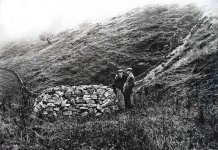
The shaft was dropped by the DPC in 1909 after they dismantled the beehive cap, and I suspect that most of the deads that still litter the slope and the floor of Cowlow Nick are from that. It led into a large chamber blocked with rubble at the bottom, but they quoted the shaft and chamber having a combined depth of 180 feet (55m). Given its lower position on the hill, that would lead it to roughly the altitude of the Speedwell Streamway, though obviously nowhere near it - but far closer to what we're looking at.
The thing that baffles me about this shaft is who covered or backfilled it again afterwards? I'm not sure exactly when the NT took over the ownership of this parcel, or who from, but I'm guessing it was filled in before that. It has a very solid retaining wall on the dale flank and a small hole in that shows the shaft top to be totally backfilled 'at the top'. But for 55m? Can you imagine how much rubble would have had to be hauled up the hill to then backfill a 2m-diameter shaft for 55m depth? We just hauled out less than half that, and it's a considerable volume when restored to the surface. I suspect it's not backfilled that far - nor many of the others around there.
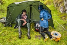
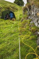
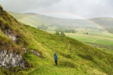
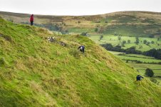
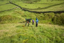
The photos below show another scan line being sent down the flank of Cowlow Nick, after being directed over the known passage in Son of Longcliffe at the top end as a 'control' - it crossed the Tellyers Venture shaft top before crossing all the other workings in the floor of the dale and then re-entering the lava lower down. The results weren't entirely conclusive, despite being done at high resolution (1m gaps in the cable) - though this does reduce the depth scanned considerably.


")