• Win a Rab Nexus Pull-On with the 1st of the Inglesport Fabulous 5 competitions!

    Caption competition, closes Friday 25th April

    Click here to enter

The Mereless Gill

Samouse1

Well-known member
An after work trip today found me down Meregill, to have a look at the non existent lake! I know it has been mentioned on here before by a few people but it really is a sight to see.

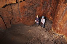
Dropped down off the fallen tree, which is actually still alive and has leaves and buds currently, I landed next to the usual waterfall. I was immediately greeted by the wonderful smell of death, and looked around for the wooly culprit, it seems almost standard that there's one down there. Down the slope, looking up at the eyeholes above, it really is an impressive bridge across the top! At the far end, another small waterfall comes down from p101b. Here is where the slope meets the far wall and the water sinks into the mud on the true left.

PXL_20250409_170504101.jpg

The uninspiring mud pile at the bottom of the Mere.

This is also where @Speleodroid has/had a dig, from which the sound of falling water could definitely be heard. More info here: https://ukcaving.com/board/index.php?threads/meregill-hole-minor-extension.24943/

PXL_20250409_170517395.jpg

Looking into the dig, where the rop is the rift drops away down to the right.

My main reason for going was to get a survey of the area where the Mere sits, so I set about doing that, but not before I went down into the very bottom of the slope, where it turned out the mud wasn't quite as firm as it looked. Both feet fully suctioned in, I stood there for a while contemplating how embarrassing a call out it would be, and that I'd never live it down. Eventually I freed my feet, miraculously still in their wellies, and set about shooting a laser pointer about the place.

If I hadn't been preoccupied with the survey, I'd have taken more photos! Alas, you'll all have to go yourselves after a spell of dry weather. The preliminary survey data shows that the bottom of the mere is approx 25m below the "overflow" into Meregill proper. The mere is about 40m long and between 5 and 10 metres wide. The slope is about 30-35 degrees, so I'll let someone else do the maths on how much water roughly there is when it's full!

I'm unsure if the horrible mud I encountered at the bottom there is the same as Cotters Pool I've read about. I think whispering this at the end will summon Pitlamp to enlighten me!
 
Evening Samouse1, here's something I posted on 10th June 2016:

"Have you ever been to Meregill and wondered what lies below the sinister-looking Mere? Well, until last weekend the Mere had dried out; there was still a bit of a cascade going down the entrance pitch, but this eventually sinks into the floor at some point on its descent. I’ve not been over to the Dales since then, but there has been a lot of thunder rolling around us near Kendal, so there might have been heavy rain over Ingleborough that has filled the Mere up again, for all I know.
We popped down there on Sunday (5th) afternoon to have a look and take some pictures, but unfortunately it was very ‘steamy’ down there and the snaps didn’t work too well.
What is revealed is quite a large passage that descends steeply. At first it’s rock-strewn, but then becomes a bit muddy. It must be from 6 to 10 metres wide, and extends for some maybe 40 m horizontally. We tried to guesstimate how deep we went, and estimated around 30 m below the level of the Mere – which means that when the Mere’s up, there’s a lot of water held up there – may 4 or 5 M litres?"

So, it seems that my estimate as to the size of the place wasn't too bad.
 
I'll try to help if I'm able. This is certainly interesting. There have been various reports over the last three decades (and a few before) which collectively suggest that the nature of the sediment floor of the mere can change dramatically.
I'm wondering if the water sound was either what's left of the Meregill stream or the inlet from P101b falling into Cotter's Pool.

I think your efforts to find the volume of water here in normal weather are really valuable; the mere is probably unique in the Dales.

Where exactly did you get to on the elevation in Descent 127 page 8?
 
Here's a picture I took way back in 2016; it would appear that the level of silt /crap at the bottom is much higher in your picture, Samouse. Also I don't remember the mud being particularly clinging and horrible back then:
 

Attachments

  • Merergill dry 1.jpg
    Merergill dry 1.jpg
    343 KB · Views: 136
Brilliant Fulk. I'm so glad we have good photographers like you to record these things, for comparison.
 
I had a trip down there with Speleodroid a few years ago to look at his dig - the one mentioned in the linked report and probably the same year. We looked at the rift he had descended but it was incredibly tight and clearly little room to work. We did think that by digging under the wall, below the climb into the bedding you might end up in the same place. I guess that would be somewhere just in front of the two people in Fulk's photograph.
 
It does seem like there's more sediment build up since you were there Fulk. I got to the far wall, but the drop down to "Cotters Pool" was definitely absent. I wonder if it's one that builds up over time and then eventually will return to the good old days!

PXL_20250412_151007831~2.jpg

I'd guess it was something like this based on my survey data? The thing is, with the sediment I suppose it could be very completely different level, which I think my survey data might show compared to the elevation in Descent. I'll compare the two properly to see the difference, but I definitely think that especially the Cotters Pool section is very different.
 
Thanks Samouse1. I see what you mean.

Was there a dribble of water coming down the far wall, originating from the P101b inlet?

Did you see the shale band marked on the Descent drawing?
 
I dint remember seeing one that low down. There was a distinct line which was where the rift went off to the left, and it was overhanging on the lect as well, but that's the only other line I remember seeing. A really interesting place!
 
Are you sure you got to the far wall? When I went in 2015 I thought I had, but after useful discussion on here (https://ukcaving.com/board/index.php?threads/the-mere.19016/) concluded that I probably hadn't got that far. My memory is somewhat sketchy of a quick dash down a decade ago, though!
Re-reading that thread, it almost sounds like the choked fissure is actually the dig? At some point during another dry spell I will have to go and abseil in from the opposite end and see what's there!
 
If you do drop in from the far end, be prepared to have to hunt for belays and bear in mind that the obvious tree is in senescence and therefore suspect. There is also loose rock.

There are some holes on the right side of the small gully leading to that pitch. From memory these are 14 mm to accept a traditional 14 mm rawlbolt. (Also from memory, one of the holes has a stuck plug in the bottom so can't be used.) There is also a thread on the left side a bit further back which accepts a wire sling. To make it safe you'd really need to put some bolts in somewhere over the edge of the drop if you can find decent rock.

Bottom line is rigging that pitch would need careful thought; it's not just a case of chucking a rope down.

Hope that helps.
 
Re-reading that thread, it almost sounds like the choked fissure is actually the dig? At some point during another dry spell I will have to go and abseil in from the opposite end and see what's there!
Yes. It'd certainly be nice to work out the situation for definite. Your description sounds quite like mine in the linked thread, but we didn't resolve it definitively then, and it seems we haven't here either.

The best thing would be for someone to drop both ends to be certain!
 
Given Fulk's record of it flooding, it will presumably sometimes deposit and other times flush mud through:
 
Right, so curiosity (and the weather more or less holding) had me back there this evening. I had a look at the descent down the other (north eastern/downstream) end, but as Pitlamp said the tree is not to be trusted as an anchor. With a lack of suitable anchors I backed off from there.

Back down the CNCC approved mere entrance, I had a good look and resurvey of the far end. The P101b water could be seen tumbling down from above and below, so I'm confident that the "far wall" I reached is what I've marked below in purple. The blue line below is a rough estimate of where the floor was, based on the shale bands. The lowest shale bands is the band where the rift/dig goes off.

PXL_20250412_151007831~4.jpg


I'd presume the sediment has slumped/been washed into what was once Cotters Pool, which during that drought when first named was blocked at the bottom by sediment, so wasn't draining away, whilst the rest of the mere drained away in the shale band? Pure postulation of course, whilst mulling it all over in the Station Inn with a pint!
 
..Or Cotters pool just drained away and was only a short lived feature. Your description and map are very much how I remember it from 2019.
 
I haven't been down Meregill for years. Does this suggest that the mere water has another alternative route to God's Bridge other than the 'normal' way?
 
Back
Top