2021 International Year of Caves and Karst: BCRA online seminars

JoW

Member
As a contribution to the International Year of Caves and Karst (IYCK), BCRA is hosting a series of online seminars that emphasise the scientific importance of caves and karst, and which describe ways in which BCRA supports cave research. The seminars will be held on the second Monday of each month in 2021, 19:30?21:00 UK time, commencing in February. These talks will use the Zoom platform.

So far we have 2 seminars on the calendar:

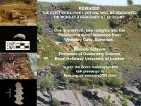
Seminar 1 ? Pleistocene fossils from Westbury Cave
One in a million: new insights into the Pleistocene fossil sequence from Westbury Cave, Somerset
Speaker: Danielle Schreve, Professor of Quaternary Science, Royal Holloway University of London
Monday 8th February 2021 Starting time: 19:30 GMT.

This talk will highlight the important resources contained within cave sediments and how the information that can be gained from these sediments can aid our understanding of fast changing palaeo-environments and palaeo-climates during glacial/interglacial episodes. Understanding the past is key to our understanding of the future!

Seminar 2 ? Hydrology of the Castleton Area
Castleton, Derbyshire: The world's most complicated simple karst hydrological system?

Speaker: John Gunn, Honorary Professor, School of Geography, Earth & Environmental Sciences, University of Birmingham
Monday 8th March 2021 Starting time: 19:30 GMT.

This talk will examine the complexities of underground water movement in limestone areas and will show how data collected within caves contributes to understanding the flow from springs and flow in the rivers that they supply.

For more details on how to join, please visit: https://bcra.org.uk/seminars2021.html
 

Attachments

  • BCRA - IYCK.jpg
    2.3 MB · Views: 3,579

JoW

Member
A reminder that the first talk is this Monday, 8th February. Talks 3 and 4 (April and May) will also be announced soon  :)
 

Attachments

  • BCRA-IYCK 1 Schreve.jpg
    BCRA-IYCK 1 Schreve.jpg
    193.6 KB · Views: 183

Jenny P

Active member
Second one tonight.

John Gunn on Hydrology of the Castleton Area - all about Peak/Speedwell system.  Not to be missed!
 
Jenny P said:
John Gunn on Hydrology of the Castleton Area - all about Peak/Speedwell system.  Not to be missed!

And very good it was too. Recorded, I believe, although I don't know how to access it.
 

Andy Farrant

Active member
John gave an excellent talk last night on the "Hydrology of the Castleton Area, Derbyshire: The world's most complicated simple karst hydrological system?" with over 170 attendees including from the States and New Zealand, and 33 questions! The complex hydrology was really well explained. It is clear the Peak-Speedwell system is certainly not 'simple' and I would wager is even more complex that he outlined...  :sneaky:

The lecture was recorded, but as a general rule we won't make them publically accessible as there may be material contained within the lecture that the speaker may not wish to be shared (and potentially reproduced) more widely on the internet, for example data that will be published as a paper, or extracts of a cave survey (best not go there...!). In general, I would suggest you contact the person giving the lecture in the first instance to see if they would be willing to share it on an individual basis. 
 

pwhole

Well-known member
A very enjoyable seminar, and knowing that more remains to be discovered, especially after some of our recent traces, keeps the project very exciting. I had the pleasure of doing some work in the Bottomless Pit with Mark McAuley and Dave Shearsmith last year during one of the pulsing episodes, and it was extremely interesting to watch as there seemed to be at least two, and possibly three cycles superimposed upon each other - a long-period cycle of about 40 minutes with shorter-period cycles overlain - these were in the region of 4-5 minutes. The water in the Far Canal would rise up and overflow the platform, flooding it to about 5cm, and then drop rapidly again. The longer-period cycles were larger and would flood it to about 15cm for a longer period, but the shorter ones were observable during this time. The phases of pulsing seemed asynchronous to me, but watching it visually is not very accurate, admittedly.

We were trying to drain the Near Canal at the time, as a showcave boat had sunk at the departure dock and needed refloating, so this was not helpful. Eventually we had to go back to the office and collect a load of sandbags to make a dam around the landing dock to keep the flood pulses out so that we could empty it. We even ended up using our dinghy as part of the dam. But it worked in the end! The images below show one of the pulses running through.
 

Attachments

  • _IGP1314_sm.jpg
    _IGP1314_sm.jpg
    279.7 KB · Views: 168
  • _IGP1346_sm.jpg
    _IGP1346_sm.jpg
    276.4 KB · Views: 168
  • _IGP1335_sm.jpg
    _IGP1335_sm.jpg
    322.1 KB · Views: 158
  • _IGP1342_sm.jpg
    _IGP1342_sm.jpg
    273.4 KB · Views: 184

Logismos

New member
Somehow I didn't notice this until just now!

Anyone know the best way to contact John Gunn?
I'm gutted that I missed it. Need the new material to distract freshers from their numb ankle sock'd feet when we're in the Peak streamway ;)
 

ChrisJC

Well-known member
pwhole said:
A very enjoyable seminar, and knowing that more remains to be discovered, especially after some of our recent traces, keeps the project very exciting. I had the pleasure of doing some work in the Bottomless Pit with Mark McAuley and Dave Shearsmith last year during one of the pulsing episodes, and it was extremely interesting to watch as there seemed to be at least two, and possibly three cycles superimposed upon each other - a long-period cycle of about 40 minutes with shorter-period cycles overlain - these were in the region of 4-5 minutes. The water in the Far Canal would rise up and overflow the platform, flooding it to about 5cm, and then drop rapidly again. The longer-period cycles were larger and would flood it to about 15cm for a longer period, but the shorter ones were observable during this time. The phases of pulsing seemed asynchronous to me, but watching it visually is not very accurate, admittedly.

Not sure if this warrants another thread, but...

Pondering on these pulses last night, I wondered if anyone has done any analysis on the possible multiple frequencies that you allude to.

If one had a few datasets, running a Fourier Transform would identify what the frequency components were, and how many of them there were (subject to signal to noise considerations of course).

It might well be that each frequency component is caused by and a function of a single hydro-logical feature (e.g. siphon, silt slump, etc).

And that even though the different measurements appear to show different dominant (fundamental) frequencies, you might find the lower amplitude component in one measurement is the dominant one in another, perhaps showing some linkage between different parts...

The maths is easy BTW.

Chris.
 

pwhole

Well-known member
Matrixman355 said:
Somehow I didn't notice this until just now!

Anyone know the best way to contact John Gunn?
I'm gutted that I missed it. Need the new material to distract freshers from their numb ankle sock'd feet when we're in the Peak streamway ;)

PM sent.

Also, Chris, I think part of the problem is that so many of the obstacles for water on the way are so varied in the way they affect things - like the Boulder Piles are relatively immovable (though a giant one did move last year!), whereas many of the sediment blockages vary in resistance constantly and also act like valves on different loops, with less predictable outcomes. I suspect intermittent overflows into parallel passages or longer loops may also account for some of the pulsing. Plus there are several other conduits known to exist but not yet entered - the one from Rowter Hole to Russet Well, for example, which, if it follows Faucet Rake, might take some of the water from below the Bottomless Pit sump, and would run along the front end of Peak Cavern, near to Moss Chamber, if it stuck to the rake alignment.

We did some tracing from the dig face at Longcliffe last year, which is near as dammit intersecting the Speedwell Near Canal at the east side of the Halfway House junction, though slightly lower than the canal as far as we can tell, but a good 300m north of the Bottomless Pit. The first trace was in wet weather and very fast, and started reaching the village springs in less than ten hours, well over twice as fast as any trace from the BP. We also did a trace in a wet-weather sink on the hillside at the same time with different dye and that too reached the vilage very quickly, though only at Peakshole Sough, not the others. We did another trace in drier weather which was much slower, probably due to ponding en-route, but this time the canal turned green, which was most unexpected as we think we're lower than the water level.

But either way, these fast times show that the route taken was not via the Speedwell streamway but a 'new' conduit - which may be the same as that from Rowter Hole. The drainage from Blue John and Treak Cliff must also flow close by, not least as the shale boundary is overlapping the route. Also Peakshole Sough has now been shown to be connected to the complex junction beneath the gorge just before resurgence, via an upwelling in the floor near the entrance. We got near-identical times for traces reaching there and Russet Well, but vastly different concentrations, with PS being very strong and RW being very weak, suggesting the 'new' conduit mixing with the Speedwell water at the last minute before resurgence.
 

Mark Wright

Active member
I really enjoyed the webinar. It was good to catch up on the underground hydrology around Castleton.

Whilst we can speculate as to why the water does this or that, there is only one way to find out for sure and that?s to pick up a shovel and crowbar and start digging.

I think revisiting the Eldon Hole dig would be a good start in trying to answer some of those questions.

I think the authorities that banned us need to wake up and rethink their ridiculous decision in this International Year of Caves and Karst.

Mark
 

pwhole

Well-known member
DCA did have a plan in place to take folks from Historic England down on a winch last summer, and they said they'd do it, but Covid wrecked that - though I suspect it could have been done quite safely if they'd checked the dig one at a time. Oh well - maybe this summer! There's an online UCF meeting in a month, so it would be well worth having it as a discussion item. You could join in, it would be very useful.
 

ChrisJC

Well-known member
Mark Wright said:
Whilst we can speculate as to why the water does this or that, there is only one way to find out for sure and that?s to pick up a shovel and crowbar and start digging.

There is another way and that is to use technology. What is required is a number of devices, lets call them Captain Nemo. Each one is:
- spherical, about the size of a ping-pong ball
- slightly buoyant
- containing a microprocessor, memory and some sensors.
- sensors would be an accelerometer, a magnetometer, and pressure.
- Bluetooth for location and interrogation

You would lob a handful in at Giants in pulsing flood conditions.

Then you'd sit and wait in Castleton and fish them out as they float past. You'd lose a few, but so be it.

You could then work out from the data:
- Journey taken, how much was submerged, and how deep, and how much was in 'open water' conditions
- Very approximate journey profile (double integrate the accelerometer data)
- Direction of travel

If you added a microphone, you might also be able to tell if it was in open water by the noise. I guess it would be quieter when submerged.

You would have to make it withstand pressures of at least 20 atmospheres.

The technology is cheap and readily available.

It would tell you an awful lot.

Chris.


PeteHall

Moderator
ChrisJC said:
There is another way and that is to use technology.
...

The technology is cheap and readily available.

This is a really fascinating idea. Presumably just waiting for a keen engineer to build it/ them?

Though I'm not sure quite how the accelerometers would work, as they would likely be reading all over the place as the Nemo's were swirled and rotated around along their journey. I'm sure the data analysis would be bloody complicated too!
 

Mark Wright

Active member
ChrisJC said:
Mark Wright said:
Whilst we can speculate as to why the water does this or that, there is only one way to find out for sure and that?s to pick up a shovel and crowbar and start digging.

There is another way and that is to use technology. What is required is a number of devices, lets call them Captain Nemo. Each one is:
- spherical, about the size of a ping-pong ball
- slightly buoyant
- containing a microprocessor, memory and some sensors.
- sensors would be an accelerometer, a magnetometer, and pressure.
- Bluetooth for location and interrogation

You would lob a handful in at Giants in pulsing flood conditions.

Then you'd sit and wait in Castleton and fish them out as they float past. You'd lose a few, but so be it.

You could then work out from the data:
- Journey taken, how much was submerged, and how deep, and how much was in 'open water' conditions
- Very approximate journey profile (double integrate the accelerometer data)
- Direction of travel

If you added a microphone, you might also be able to tell if it was in open water by the noise. I guess it would be quieter when submerged.

You would have to make it withstand pressures of at least 20 atmospheres.

The technology is cheap and readily available.

It would tell you an awful lot.

Chris.

In the meantime, I?ll get my crowbar
 

ChrisJC

Well-known member
MarkS said:
Wouldn't there be a significant issue with buoyancy?

I don't think so. Choice of housing material would play a part, but ultimately, it would just get bigger to ensure buoyancy.

Chris.
 

Andy Farrant

Active member
Similar sensors have been used to investigate subglacial flow under ice sheets. In preliminary tests on the Leverett glacier in West Greenland during August 2009 researchers demonstrated that radio frequency detection methods can be used to locate and retrieve dummy sensor packages: 50% and 20% of the dummy sensor packages introduced to moulins at 1 and 7 km from the ice sheet terminus respectively, emerged in the sub-glacial stream (incidentally I used to share an office with one of the co-authors). Nasa once used rubber ducks but they were never seen again.

See
https://ui.adsabs.harvard.edu/abs/2009AGUFM.C43B0506B/abstract
https://onlinelibrary.wiley.com/doi/full/10.1002/hyp.9451
https://core.ac.uk/download/pdf/227104429.pdf
http://news.bbc.co.uk/1/hi/sci/tech/7780200.stm

Of course, retriving the sensors at resurgences would be much easier than on pro-glacial outwash fans, just use a large net.

If someone were to develop this technique for caves, that would be fantastic, although the risk of sensor packages getting stuck would probably be much higher; many UK sumps would not be suitable. Perhaps trial with a few dummy sensors first, and then try with the real thing. They would need to be cheap enough to lose a significant proportion. The BCRA CSTRF fund would be there if anyone is serious.
 

MarkS

Moderator
ChrisJC said:
I don't think so. Choice of housing material would play a part, but ultimately, it would just get bigger to ensure buoyancy.

I was thinking of situations where there may be fairly deep sumps where buoyancy could be problematic.
 
Top